


Hi all,
I was at a AI for ecology working group a few weeks ago and was asked to look into an airborne model for detecting livestock to assist in land-management, agriculture and other applicants. I was surprised to find that there was not an existing open-source model readily available. This surprised me. I am aware of many projects on Roboflow and a couple of nice research papers ->
GitHub - Alexandre-Delplanque/HerdNet: Code for paper "From Crowd to Herd Counting: How to Precisely Detect and Count African Mammals using Aerial Imagery and Deep Learning?"
Code for paper "From Crowd to Herd Counting: How to Precisely Detect and Count African Mammals using Aerial Imagery and Deep Learning?" - Alexandre-Delplanque/HerdNet

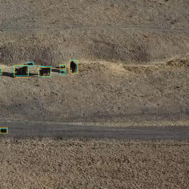
I did a quick literature search, wrote a couple dozen corresponding authors and gathered up 4 or 5 five small datasets that I could find. My student trained up a model in our python package for airborne machine learning (Deepforest). Below we have ground annotations in orange, predictions in blue. A decent start and random-train/test accuracy at about 90%. That's all well and good, but we need alot more data to assess generalization, zero-shot performance and how it would work in different resolutions.
# Areas I could input from the community.
- Would an open-source detector be useful? In what applications? What kinds of imagery would it be applied to?
- Do you or others have access to labeled or unlabeled airborne data, from UAV to satellite that include livestock? Quick list of what I've found so far.
- How should we best share and bring models to the community?
This is all a side project, and more of a 'blog post' idea rather than an academic paper, so just feeling out where the community is and potential interest.
Best,
Ben Weinstein
12 August 2024 11:03pm
Hi @benweinstein,
An open-source detector would be great! from my point of view it would be ideal if it could be applied to Very High Resolution satellite imagery.
Maybe you are aware of this already but there seems to be a group at Missisipi State University who is putting together a platform for Aerial Wildlife Image Repository (AWIR) to promote research and storage of wildlife imagery and data (I haven't looked into it - it seems you'd need to sign up but looks potentially useful).
They have recently published a paper and their dataset is open source.
I would also suggest posting this discussion in the "Remote Sensing & GIS" and the "Drone" group.
Cheers,
Elsa


23 August 2024 4:46pm
Hi Ben,
We are doing aerial surveys for livestock and elephants in which we take pictures of groups/herds. Not sure if that would be of use, but happy to contribute.

Lars Holst Hansen
Aarhus University


6 September 2024 12:46pm
Hi Ben!
Great initiative!
A review of deep learning techniques for detecting animals in aerial and satellite images
https://www.sciencedirect.com/science/article/pii/S1569843224000864#b0475
lists a number of data sets (incl. one published by you it seems...)
Also, @dmorris keeps a list of Terrestrial wild animal images (aerial/drone):
https://lila.science/otherdatasets#images-terrestrial-animals-drone
List of other conservation data sets - LILA BC
LILA BC - List of other conservation-related data sets

which seem like it might be useful for you.

9 September 2024 8:10pm
Hi @benweinstein !
- Surely a general detector might be very useful for detecting objects in aerial imagery! Maybe something similar to what MegaDetector does in camera trap images, generally detecting person, animal, and vehicle (and thus also empty photos). This could greatly improve semi-automated procedures. It could also serve as a first step for context-specific detectors or classifiers to be developed on top of this general one.
- There is also the WAID dataset that is readily available. Our research group could also provide images containing cows, sheep, and deer from South America.
Best
Elsa Carla De Grandi
Fauna & Flora