Welch Labs - Learning to see

31 March 2017 11:10am
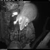
Camera Trap Pictures Wanted

6 March 2017 11:38am
31 March 2017 10:18am
Paul,
I can get some when I do my next deployment (sometime next week at this stage).
Colin

31 March 2017 10:21am
Nice, thanks Colin! Are you deploying cameras as part of the phascogale project?
Paul - are you quite sure you don't need some camera trap photos of some gorgeous Australian mammals for your guidelines as well?
31 March 2017 10:28am
Steph,
Not quite. I'm coordinating a fauna monitoring project for a Landcare network and, of course, we hope to get phascogales. I've just retrieved a batch of cameras from nest box monitoring duty for the phascogale project and their next role will be to investigate a possible sighting of a Squirrel Glider in the area.
Colin
lidar imagery
6 March 2017 11:53am
7 March 2017 11:11am
Hi Paul,
So you have had the good fortune to make this ask during our annual #Tech4Wildlife photo challenge, but unfortunately you've been foiled on this ask (unlike the acoustic and camera trapping photos) - we've yet to see any lidar images shared in the photo challenge. So I'll add a request on top of your request.. if you do have some lidar images that you are willing to share with Paul, please add them to the #tech4wildlife photo challenge mix over on Twitter as well!
To participate this year, all you need to do is:
- Take a photo of how you are using tech to save wildlife
- Share it on Twitter: tell us a bit about your work and the tech featured
- Remember to use the hashtag #Tech4Wildlife and tag us at @WILDLABSNET
Cheers,
Steph

31 March 2017 10:19am
Hi @P.Glover.Kapfer
Have you looked at the Environment Agency LiDAR data available under the Open Government Licence and available from http://environment.data.gov.uk/ds/survey/index.jsp#/survey?
It might also just be worth asking Amphibian and Reptile Conservation whether their LiDAR data are available. They have a 2 ppm coverage of the New Forest National Park from 2015 which is shared with Natural England (contact Arne Loth). The New Forest National Park Authority also have a 4 ppm dataset from a few years previous, though I'm not sure what the copyright status is with that one (contact Lawrence Shaw).
As a fairly frequent LiDAR user, I'd be interested to know more about your best practice guidelines and website.
Thom
Welcome to the GIS group!
16 March 2017 5:59pm

30 March 2017 4:25pm
Hello. I'm working at Korea National Park Service, GISP, and a charter member of OSGeo Foundation. I'm teaching various open source GIS applications such as QGIS, GRASS GIS, Orfeo ToolBox, OpenDroneMap. Nice to know this GIS group!

30 March 2017 5:47pm
Hello, I am currently using QGIS for assessing conservation planning effectiveness and identifying gaps in networks of protected areas in the Neotropics. It's really nice to be able to share and gather knowledge about GIS functionalities.
31 March 2017 12:52am
Hi, I'm a GIS consultant to conservation and research groups, mostly using ArcGIS and, increasingly, QGIS. Lately I've been doing a lot of work with satellite imagery. I've done quite bit of Python programming as well. I hope to meet like-minded folks for information-sharing and maybe even collaboration.
15 Risks and Opportunities for Global Conservation

31 March 2017 12:00am
RGS Geo-technologies for field research workshops
21 March 2017 7:54pm

29 March 2017 4:42pm
Thanks for sharing. It looks as though they've recently been cancelled.
29 March 2017 4:59pm
Ah - a shame they've been cancelled, thanks for that update Joel. As an advanced GIS user yourself (you work in GIS with Vulcan, right?), would the higher-level course Thom's looking into organising be of interest?
29 March 2017 6:13pm
Thanks for the update, @joelm . I wonder why they were cancelled - lack of uptake or something else? I'll see what I can find out.
Modeling techniques

29 March 2017 1:20pm

29 March 2017 1:38pm
Hi Priyanka,
From your post, I believe you mean applications for modeling data, right? There are many depending on the area or environmental topic you are working on, such as QGIS, Movebank, Google Fusion Tables, iPlover, etc. What does everyone else in the community have to say about this?
@sivakumar @Hangiw @dave @wai.yee @StephODonnell - What are your thoughts?
29 March 2017 2:42pm
Hi Priyanka,
I'll second what John's posted - it would be helpful to know a little more about what you're looking to do before we can answer your query. What is you project? What sort of data do you have? What are you looking to model?
Steph
29 March 2017 3:11pm
Hi Steph,
Actully, it's my presentation topic in class, Now I don't have a data but have to deliever an information in general. So can I produce depctive data to show how to represent any model.
Priyanka
From the Field: Paul Millhouser and tracking migrating kestrels with low cost, light based geolocators
29 March 2017 12:00am
Drone training for forestry and conservation

27 March 2017 3:33pm
27 March 2017 5:04pm
Great link, thanks for sharing!
28 March 2017 10:03am
Thanks for sharing, @Lot
Adding a little more info in case anyone was interested but didn't click through - also, earlybird tickets are still available.
WORKSHOP & TRAINING:
Drone applications in sustainable natural resource management
When: 15th to 19th May, 2017
Where: Palangka Raya, Central Kalimantan, Indonesia
For whom: Members of forestry companies, governmental environmental institutions, non-profit organizations and university research departments, as well as students.
@TWhitten this may be of interest for Indonesia team members using drones?
Citizen Science Conservation Apps

5 April 2016 2:24pm

25 January 2017 8:31pm
Hi all,
I am curious what the reason by the original poster to target applications specifically. That might help me provide us provide you with greater detail. There are likely thousands out there and if you are also interested in web platforms either as data entry portals or doing project online data analysis that are yet again thousands more. Many web based platforms have accompanying applications as well. If we look at the birding community, there are already several in Australia for example, but eBird is a global project to record and distribute wild bird observations, which is run by the Cornell Lab of Ornithology. It has a web platform but several apps have also been created to enter data via mobile phones. This is just one example of such technologies. Also I mentioned the global project finder SciStarter in a previous post, and just wanted to let you know, they are VERY interested in knowing about any projects you find that aren't in their data base. There are also interested in partnering with other groups to aggrigate projects. Here in Australia for example, as part of my role with the Australian Citizen Science Association (ACSA), I have faciliated such a partnership with the Atlas of Living Australia'/ACSAs project finder. An API now exhanged data across protals regardless of what the information is originally entered.
Best regards,
Jessie
26 January 2017 8:24pm
Hi guys,
I just spoke with the folks at Scistarter, and as a result they added a filter for applications, and also a an App URL field to the appropriate project pages! :) Hope that helps!
27 March 2017 4:24pm
@Sivakumar This thread seems interesting
Conservation GIS Group Social
21 March 2017 7:25pm
27 March 2017 7:35am
Last week's GIS social topics included:
- IfSAR and InSAR Interferometric synthetic aperture radar, as used by the German Aerospace Center (DLR) in their new TanDEM-X high resolution global digital elevation model. The new GDEM has a vertical accuracy of < 1 metre and an xy resolution of 6 metres. You can read more on the project web page https://tandemx-science.dlr.de/.
- Using Maxim iButton termperature data logger arrays to monitor the diurnal temperature fluctuations of different habitats and microhabitats. We also touched on sampling design and interpolation methods.
- Towards the end of the evening we discussed the difference between geodesic and Euclidian distances, the planar nature of the solar system (see Laplace's invariable plane) and whether the galaxy has a ‘right way up’.
Beverages of choice were Greene King’s Abbot Ale and IPA Special Reserve. Put the next GIS social date in your calendar now and don’t miss out – it’s Thursday April 13th.
The Noise Egg: Testing the Effects of Underwater Noise on Aquatic Animals
27 March 2017 12:00am
How to stop the thieves when all we want to capture is wildlife in action
23 March 2017 12:00am
From the Field: María José Bolgeri and tech to alleviate Puma-Human conflict
22 March 2017 12:00am
Upcoming capacity building conference
14 March 2017 5:15pm
21 March 2017 7:17pm
I went to one of the ERT Spatial Ecology and conservation conferences in Bristol a couple of years ago. It was invaluable - I discovered things there that I'm now using extensively at work. Plus, Mark is a great guy. I checked back recently and saw that this was happening - it sounds wonderful - have a great time! The WILDLABS.NET session looks awesome!
The Return of the CCF Conservation GIS Group!
17 March 2017 9:03am
Turtle Seminar
15 March 2017 2:06pm
Recommendations Needed: Real-time enabled camera traps
17 August 2016 2:56pm

9 March 2017 7:32am
Hi Kai,
thanks for the links. Interesting. I requested them for pricing details.
The Panthera Anti-Poaching Cam makes use of existing networks and costs about 350 USD. That is not very expensive, is it?
Cheers,
Jan Kees

9 March 2017 9:51am
Hi Jankees
Thanks for your reply,
If there have existing network like RoyalKPNN.V. provide mobile phone service, there will be no problem, 3G/4G camera traps will works well. each cam 250 USD at the moment.
Now days hundreds of chinese tech team are working on LoRa and NB-IoT solutions as well. All of them want to be successfull like HUAWEI,ZTE and DJI. Nice people, good team, team work ,working 12 hours each day like machine, like arms race.
I am sure they are willing to support anti-poaching. I am not techman,but we are chinese, we have the duty to solve problems, be responsible for it. If you come to china oneday, let me know.
Thanks, and your sensingclues is great.
Regards
Kai
14 March 2017 6:13pm
A number of good points have been made. In terms of remote-enable camera traps, you will mainly find one that use cellular data signals to transmit images. Typically these are thumbnails rather full resolution, so you will likely still need to retrieve teh emory cards for analysis. Also, traps that transmit images tend to have a lionger time lag between shots, which can be a problem. Hunting web sites tend to have the most complete reviews and discussions of the various models.
If you want to use citizen science in the data analysis process, I would suggest looking at Zooniverse (www.zooniverse.org). It has a pretty well-thought-out platform.
Photogrammetry: mapping caves and other environments

19 January 2017 11:46am
8 March 2017 1:49pm
Hi Ollie,
You can do the photogrammetry without a drone. You just need a tripod and a camera. The drone is useful because it can move to locations automatically ensuring that you have correct overlap but in caves you obviously will not have the GPS signal you need for most off the shelf units to navigate.
Thom mentioned to me a device called a Zebedee, which should do what you are hoping for. I don't know anyone who has one though and I'm afraid I don't have a LiDAR unit to lend.
Tom
8 March 2017 1:54pm
A colleague showed me this last week - laser scanning in Nottingham's 'caves' - scroll down and check out the video.
http://tparchaeology.co.uk/caves/caveswebsite/index.htm
8 March 2017 2:03pm
For good measure, here's some cave survey porn of Hang Son Doong cave in China.
https://www.youtube.com/watch?v=tOH4gbW18Ts
Using social entrepeneurship for conservation
8 March 2017 1:45pm
Conservation GIS Group Social
6 March 2017 8:06am
Join our #Tech4Wildlife Photo Challenge this World Wildlife Day (March 3)
1 March 2017 3:32pm
5 March 2017 10:38pm
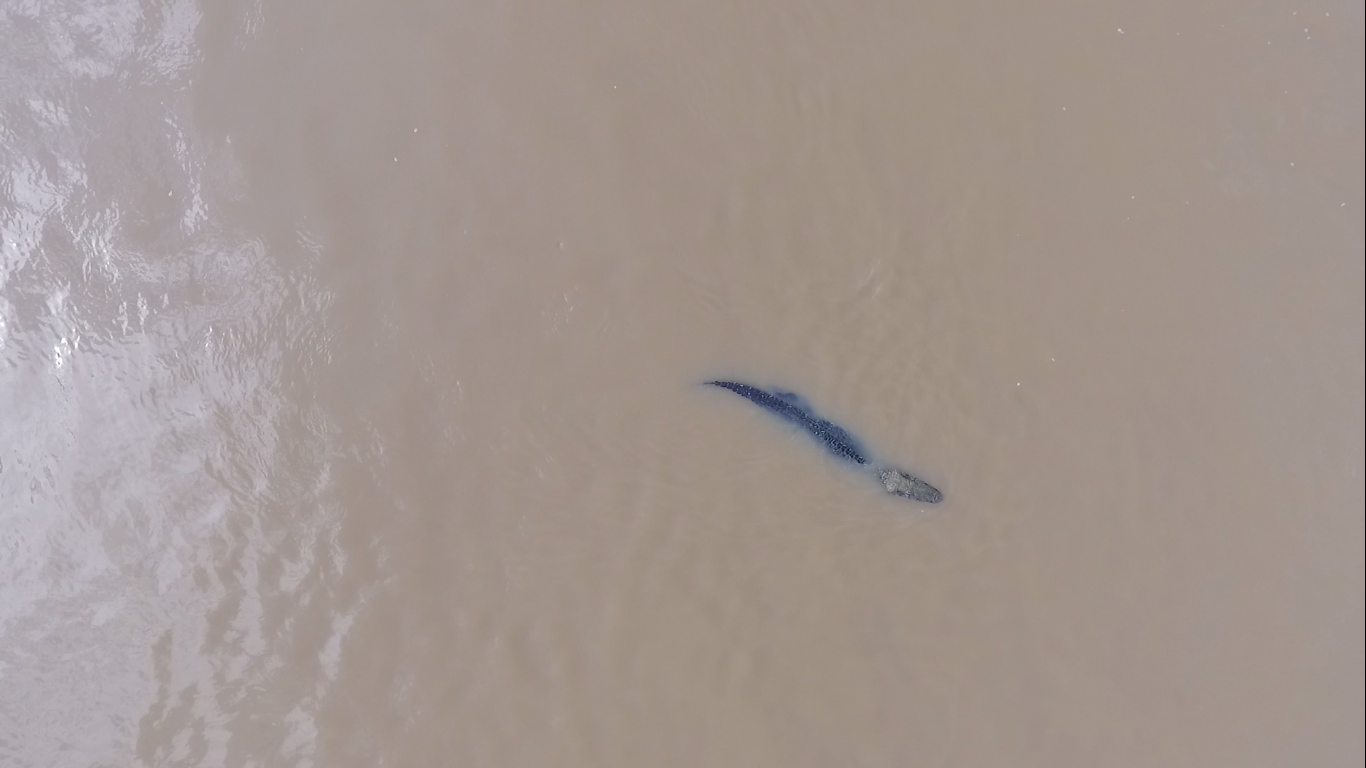
Here is a picture of the black caiman (Melanosuchus niger) taken by a drone, during an expedition throughout the Juruá river, in the Brazilian Amazon.
5 March 2017 10:40pm
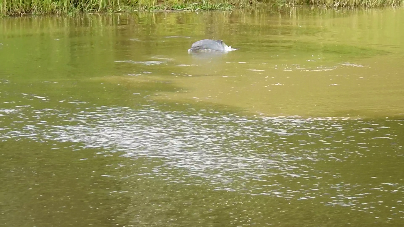
For the first time UAV was used for counting river dolphins in the Amazon. Here is the tucuxi (Sotalia fluviatilis) during a expedition in November 2016, in the Amazon.
5 March 2017 10:43pm
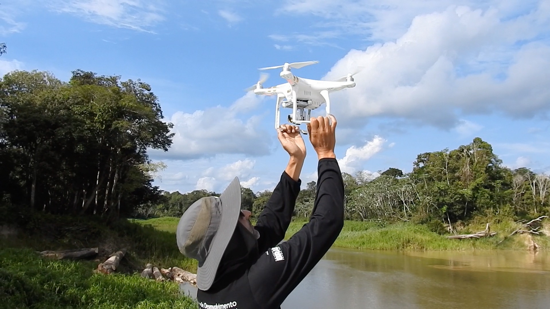
WWF-Brasil in partnership with conservationdrones and Mamirauá Institute is leading a project aiming at using drones for supporting studies on river dolphins abundance. It is the first time this approach has been used.
Survey: Camera trap effects on people
2 March 2017 4:25pm
5 March 2017 3:34pm
Thanks, i send the it to my chinese friends, i am sure some of them finished the survey.
cheers
Kai
Sign up to participate in Make for the Planet during the Earth Optimism Summit

7 February 2017 3:17am
23 February 2017 8:57pm
Oh! That's great news, thanks for clarifying Barbara.

25 February 2017 12:30am
This sounds fantastic! Am based out of San Diego but could potentially travel in and would be interested to join a WILDLABS team if there's one in the making.
2 March 2017 1:09pm
Managed to chorale a group together at my company and submitted our application last night. If any Wildlabs folk are joining as part of other teams though, I love to meet them there (and will keep my fingers crossed that we're all selected to attend!) :)
#Tech4Wildlife Photo Challenge: Our favourites from 2016
1 March 2017 12:00am
Working with wolves: Sheepdog puppies join new flock
28 February 2017 12:00am
A recap on the DC Zoohackathon
19 October 2016 7:52pm

20 February 2017 2:03am
Thanks for the report. Looks very interesting. Do you have plans to continue with new hackathons? And if so what lessons do you take from the first one?
20 February 2017 10:47am
Hi Theun,
We certainly do have plans for more hackathons (and potentially zoohackathons) coming up this year! We can't wait to share these plans with you very soon.
Our meetups and events group is the best placeo find out about local hacks and gatherings. @btmartinez just shared a hackathon you might be interested in (if you happen to be one of our washington DC members),
Do you plan on being in Washington, D.C. over Earth Day weekend? Join Conservation X Labs and teams of hackers, coders, makers, engineers, designers, entrepreneurs, creative thinkers and tinkerers to celebrate Earth Day weekend 2017 by creating solutions to challenging conservation problems in front of a global audience. Multidisciplinary teams will compete in an on-site event called Make for the Planet over three days of the Smithsonian's Earth Optimism Summit in Washington, D.C. (April 21-23, 2017). Equipment will be available to create prototypes and models of hardware and/or software solutions to specific conservation problems.
If you're keen to participate, you can discover more info and call for team mates over at Barabara's thread here.
As for your question about lessons learnt - did you have some specific aspects of hosting a hack you'd like feedback on? Are you thinking of hosting one yourself?
It would be interesting to hear from hosts like @Sophie+Maxwell and @Alasdair who did a tremendous job leading the ZSL hackathon or @demark from an organiser's perspective. Or even some of the participants like @zbaynhamherd ?
I'm also interested to hear from others who have been involved or hosted hackathons- @mygshah and @efegraus we've spoken about hackathons in the past, perhaps you might have perspectives to share?
Cheers,
Steph
20 February 2017 3:15pm
Hello - I wrote up a lessons learned from the Hack for Wildlife that we ran in Chicago. https://medium.com/@mygshah/i-just-ran-my-first-hackathon-you-can-too-49a1d1343963#.q27eyjm5z
But I'm also happy to answer any specific questions.
Gautam!
Operational guidance

26 January 2017 1:58pm
20 February 2017 10:47am
Hi Jane,
Thanks for sharing the work the Research Data Alliance is develooing. It sounds complementary to the guidelines our community has started collaboratively developing. You can see where these guidelines are at over here in this thread. It would be great to have your experience (and that of your colleagues) as part of these guidelines, so we invite you to come and join in that process of building out these guidelines and keeping them alive.
Thanks for sharing the invitation to join your kick off meeting in April - will that be held in Barcelona, 5-7 April, 2017? I'm keen to explore how we could align our efforts as it sounds like what you're proposing is more detailed than what we're envisaging, and with a complementary focus. I agree, it would be great to ensure the conservation community perspective is build into your plans, and WILDLABS is keen to help facilate that. At the very least, the guidelines I've mentioned above should be at a point then that they might be useful to feed into your kick off meeting. If you have any more information or specific asks as the date gets closer, please do share them here.
Cheers,
Steph
20 February 2017 12:13pm
Hi @twhitten ,
Over in the other thread looking at developing best practise user guidelines @Jeremy+Lindsell shared a doc that might very well provide the template you're looking for. The Univeristy of Exeter dronelab research group (led by Karen Anderson) has developed a template for researchers using drones to help them meet CAA operating standards.
You can download the PDF here:
http://www.tandfonline.com/doi/suppl/10.1080/01431161.2017.1286059/suppl_file/tres_a_1286059_sm2155.pdf
And a Word version here:
http://www.tandfonline.com/doi/suppl/10.1080/01431161.2017.1286059/suppl_file/tres_a_1286059_sm2164.docx
Thanks Jeremy!
Cheers,
Stephanie
20 February 2017 12:21pm
Hi @twhitten
The British Model Flying Association provide a specialist insurance for drone operators who are not using them as a hobby nor for commercial purposes ("aerial work"). The category is termed "data, development and demonstration" and is recognised by UK Civil Aviation Authority as a legitimate mode of opeation that doesn't fit the current binary legislation of hobby or commercial. The insurance covers worldwide liability for operation. Most other drone insurance avilable assumes you are commercial, doing "aerial work" by CAA definition, and have a formal CAA licence.
BMFA are also a good source of information about current UK Gov and EU discussions on further legistlation re drones (registering all users for eg).
Best
Jeremy
Big Ocean Button Challenge
16 February 2017 3:42pm
Vulture poisoning - tech based solutions?
29 December 2016 9:09am

3 February 2017 1:30am
This is a long shot, and I don't have much of a biology background, but : Would it be feasible to amplify the traces of human handling of meat enough to make that serve as a deterrent to any birds consuming tampered meat? My assumption is that a human has to handle meat to poison it, some traces of human-ness (fairmones/body oils) must rub off on that meat. Rather than designing sensors to trigger off specific chemicals, would we be better off just triggering off human intervention? Not sure how the sensors would be deployed, but...

10 February 2017 9:30pm
Thanks for sharing this interesting post Tarik and your insights into the problem....I like your thinking Kbala but as I understand it a sensor to detect human interference would be practically impossible with the current state of this kind of technology and at best it would be very expensive thus not feasible to use on enough birds to make an impact...
Tarik do you happen to know which of the 3 causes you mention causes the highest number of vulture mortalities? Or is there is any research on this topic?
-use in traditional medicine/uMuthi trade
-commercial farmers laying out poisoned
-rhino poachers that leaves poisoned carcasses behind
This is a great ecological concern considering the knock on effect the lose of Vultures and other raptors have on local ecosystems...
11 February 2017 7:54am
Hi Isla,
The 3 threats are all situational and location dependent. For example, in South Africa there is a very well established muti industry and huge muti markets in KwaZulu Natal and Gauteng. Use of vulture parts for traditional medicine is embedded in various cultures and there are numerous cases every year of vulture carcasses found with heads and other parts missing. There are very few parts of South Africa where predators can be found in high densities outside Protected Areas (as compared to Namibia) and so I would say that direct poisoning of vultures for Muti is probably the main caue of mortality in SA.
In Namibia, vultures are mainly (so far) an indirect mortality as a result of farmers setting out poisoned carcasses to kill predators that are either perceived threats to livestock or are actual problem animals. These farmers are targeting jackal, brown hyaena and caracal in aprticular but the end result for vultures is no different than direct poisoning for muti. Same agricultural poison used, same result. However, very worringly, there have been several incidents recently of direct poisoning of vultures for traditional medicine, particularly in the Zambezi/Caprivi area of Namibia.
As to mortalities of vultures from feeding of poisoned rhino or elephant carcasses, this is still a fairly new (I say that with not much info to go on) threat and only the various protected area authorities in the different countries will have this info. As this threat grows, i am sure that the Vulture Working Groups in the respective countries, as well as the research scientists involved will be able to map this form of poisoning and provid data on which form is resulting in the deaths of more birds. At this stage Im pretty sure that all these types of poisoning, irrespective of the root reason are causing large numbers of mortalities, given that to a vulture, a carcass is a carcass is a carcass.
I would say that it is imprtant to understand the reasons for the different forms of poisoning and then we can fight it. Bantu tribes have a very strong link to the use of animal parts for traditional medicine and black magic etc. so it is no surprise that direct poisoning of vultures for the muti trade is happening in the Zambezi region. In contrast, the poisoning of vultures in central and southern Namibia in particular is more linked to farmers (German/Afrikaans/Herero/Damara/Nama) aiming to kill predators and not vultures specifically. And of course rhino poachers and syndicates can be from any nationality,tribe or culture. So these 3 forms have different roots and need to be addressed differently. However, we are in a crisis situation and the 3 threats need to be dealt with immediately via law enforcement and strong sentances, while the research continues. We simply cannot afford to wait.
Just for your info. I was recently sent a link by another member of the forum on a new publication by Andrea Santangeli. Andrea and his team mapped vulture poisoning across the landscape for the entire country based on data gathered by various organizations. It is a fantastic paper with some really good data and reccommendations for future work and a way forward. The title is:
"Understanding, quantifying and mapping the use of poison by commercial
farmers in Namibia – Implications for scavengers' conservation and
ecosystem health"
I am aware also that SANBI in South Africa are offering a bursary for a Post-grad student to do a MSc. project on vulture use in the muti industry in SA and I know of several students who have worked on projects in SA related to the use of animal parts and potential effects on wild populations. Andre Botha of the Endangered Wildlife Trust in SA will have all or a lot of this info.
Hope all this helps!
Cheers
Tarik
31 March 2017 11:45am
Ah! Thanks for posting this Tom. It's such a well designed, simple to understand video series, and the backing track is utterly delightful.
Given the growing applications of machine learning for conservation, I've been wondering if a 'machine learning 101 for conservation' webinar or article might be a worthwhile resource to look into for our community. In looking for a link to put in here to a UCL course I know exists on this topic, I actually just came across this article: A PRACTICAL GUIDE TO MACHINE LEARNING IN ECOLOGY. Seems that Jon Lefcheck had the same thought as me and got right down to it.
If you're interested in more introductory, practical resources on machine learning, do let me know below! Also, if you know of any other go to tutorials that you've found useful, please share them.
Steph