Group curators

Talia Speaker
- @TaliaSpeaker
- | She/her
WILDLABS
World Wide Fund for Nature/ World Wildlife Fund (WWF)

Lacey Hughey
- @lhughey
- | she/her
Smithsonian Conservation Biology Institute
Animal movement technologies have already significantly advanced our understanding of the natural world, from uncovering previously mysterious migration patterns and key movement corridors to demonstrating the impacts of anthropogenic pressures and climate change. Continuing advances in the development of technologies for collecting and transmitting bio-logging data, combined with the increased availability of high-resolution environmental data and analytical developments in movement modelling, are opening doors to novel applications. However, there are still major gaps in the space, including mobilizing movement data to translate data from tracking devices into insights for application in policy and practice. This group is a place for the animal movement community to connect and discuss our efforts to advance the field.
Resources for beginners
Learn about WILDLABS Animal Movement research projects
- MoveBON Initiative Announcement
- MoveBON Follow-Up Discussion
- Virtual Meetup Season 4: Tracking Progress (A WILDLABS research project on movement ecology)
Group curators
- @TaliaSpeaker
- | She/her
WILDLABS & World Wide Fund for Nature/ World Wildlife Fund (WWF)
I'm the WILDLABS Research Specialist at WWF-US


- 23 Resources
- 62 Discussions
- 25 Groups
- @lhughey
- | she/her
Smithsonian Conservation Biology Institute
I am an ecologist and program manager with experience leading collaborative research projects in international settings. I specialize in the application of animal tracking data to conserve migratory species on a changing planet.


- 6 Resources
- 10 Discussions
- 3 Groups

- @Rutwik
- | Mr
- 0 Resources
- 0 Discussions
- 13 Groups

- @williams
- | He/Him
I am a conservationist specializing in endangered species, particularly vultures. As the Endangered Species Conservation Coordinator/Co-Founder at Biota Conservation Hub Foundation (BiotaCHF), I have conducted extensive research/conservation of vultures and other water birds.
- 0 Resources
- 0 Discussions
- 14 Groups

- @aniyaz533
- | Niyaz
A keen willdlife biologist looking forward to work on Otters ecology in Himalayan landscape
- 0 Resources
- 0 Discussions
- 5 Groups

- @tmcgrath
- | He / Him
Geographer, Program Manager, Engineering Manager
- 0 Resources
- 1 Discussions
- 11 Groups

Snow Leopard Trust


- 0 Resources
- 44 Discussions
- 6 Groups

- 0 Resources
- 0 Discussions
- 5 Groups
- 0 Resources
- 0 Discussions
- 6 Groups

- 0 Resources
- 0 Discussions
- 5 Groups

- @jcturn3
- | He/Him
Colorado State University
I am a graduate student at Colorado State University working to develop novel acoustic technology for remotely monitoring wildlife.


- 0 Resources
- 14 Discussions
- 3 Groups
- @NinaTuttie
- | She
An avid learner interested in wildlife ecology, conservation technology and community development
- 0 Resources
- 0 Discussions
- 8 Groups
- @KiaraHaylock
- | She/Her
PhD in Animal Ecology and Behavioural Physiology. Interested in the movement, behavioural and physiological responses of animals to environmental variability.
- 0 Resources
- 0 Discussions
- 13 Groups
African Parks
- 0 Resources
- 0 Discussions
- 9 Groups
Rimba Satwa Foundation (RSF), an Indonesian elephant conservation NGO, is employing GPS collars on elephants to mitigate human-elephant conflicts. RSF aims to enhance collar usage, surveillance, and automation for...
28 May 2023
Link
Filter Last X Positions

Lars Holst Hansen
Filter Last X Locations - is a new super simple but super powerful moveapp. https://moveapps.org/apps/browser/ebe11063-fd98-4d8d-a22d-f143ec434b6f I will be using this to send me the latest positions of all active...
23 May 2023
Link
This article compares and contrasts the success of their wolf monitoring efforts with both collars and camera traps. The camera traps were intended to help researchers identify individual wolves within the population,...
5 May 2023
Link
GPS collaring study of Ethiopian wolves

Ellie Warren
This news article discusses the first study to track Ethiopian wolves since 1992. The study focused on adult wolves from six packs in the Simien Mountains and used Lotek LiteTrack Iridium 250 collars. Community members...
5 May 2023
Link
Feathered forecast: Tech tools comb weather data for bird migrations

Stephanie O'Donnell
Since its launch in 1999, the BirdCast project has used weather radar data to track and forecast bird migrations across the U.S. In recent years, technology such as cloud computing and machine learning have helped make...
26 April 2023
Link
Video: Virginia Tech tracking bobcats to preserve wildlife
Stephanie O'Donnell
Quick feature of Virgina Tech project using camera traps and biologgers to track bobcats, collecting data to inform human-wildlife coexistance efforts
26 April 2023
Careers
Proposals wanted for Innovation in Practice
Ellie Warren
The Innovation in Practice edition of Methods in Ecology and Evolution is still seeking proposals about conservation technology
6 March 2023
Link
The WILDLABS Variety Hour: February 2023 - YouTube
Stephanie O'Donnell
Last week's Variety Hour is now up on youtube. It was a great session - we covered Moveapps, an awesome community project building marine biologgers, chatgpt and google earth engine vs microsoft's planetary computer....
3 March 2023
Article
Download Now: A Best Practice Guide to Satellite Technologies for Tracking Wildlife

WILDLABS Team and 1 more
The Zoological Society of London, with the support of WILDLABS and the UK Space Agency, are proud to publish this new guide to satellite technologies for tracking wildlife.
17 February 2023
Article
Researchers and conservationists are embarking on a bold initiative to save the world's most trafficked wild mammal — the pangolin
16 February 2023
Article
As part of the AniMove eLearning programme, you are now able to stream 2022 Animal movement & remote sensing course lectures opensource.
10 February 2023
Link

Hi! I created a new tutorial video on how to annotate high density acceleration data using Firetail 10 (www.firetail.de). In particular, I cover * how to automatically segment your data * how to edit and modify...
8 February 2023
July 2025

August 2025
October 2025
event

Lacey Hughey and 3 more
November 2025

November 2023
event

Stephanie O'Donnell

91 Products
Recently updated products
| Description | Activity | Replies | Groups | Updated |
|---|---|---|---|---|
| Hi Vivian,Thank you so much for your reply! I appreciate the pointers on species mixing, to clarify: I have been experimenting with deer data, but for once the project is underway... |
|
Animal Movement | 23 hours 39 minutes ago | |
| Hi Ethan, It's indeed a competitive area. My advice for you (and anybody else seeking a PhD supervisor)...Do background research on each individual potential supervisor and always... |
|
Early Career, AI for Conservation, Animal Movement, Climate Change | 4 days 9 hours ago | |
| Hi Thomas, Thanks for your input. It is helpful to get that sort of info as I am not so familiar with the topic and just starting to understand the vast array of tagging... |
|
Animal Movement | 1 day 19 hours ago | |
| We are please to inform that we have implemented the point 1 and 4 and with this have finalized the project. The latest improvements:Improvement in findability of help... |
|
Animal Movement, Data management and processing tools, Software Development | 6 days 22 hours ago | |
| Hello everyone!My collaborators and I are trying to assess the extent to which animal movement ecology is currently being integrated into... |
|
Animal Movement | 1 week 3 days ago | |
| Wonderful video! Really impressive :) |
|
Animal Movement, Human-Wildlife Conflict, Latin America Community | 3 months 2 weeks ago | |
| My name is Frank Short and I am a PhD Candidate at Boston University in Biological Anthropology. I am currently doing fieldwork in Indonesia using machine-learning powered passive... |
|
Acoustics, AI for Conservation, Animal Movement, Data management and processing tools, Early Career, Emerging Tech, Ethics of Conservation Tech, Protected Area Management Tools, Software Development | 2 weeks 1 day ago | |
| Thanks Phil - I have e-mailed you.Peter |
|
Animal Movement, Sensors | 3 weeks 1 day ago | |
| Hi, we've gotten more than 20 replies until now so thank you if you took the time to answer.And we would really appreciate if you could spare a few minutes to answer if you haven'... |
|
Emerging Tech, Animal Movement, Build Your Own Data Logger Community | 1 month 1 week ago | |
| Reopenning this discussion again in case there is some news! |
+25
|
Animal Movement | 1 month 3 weeks ago | |
| Good morning JocelynThank you very much for your comment, this is proving to be very useful advice and thank you so much for setting me on the right path!! This is very exciting!!... |
|
Animal Movement, Citizen Science, Human-Wildlife Conflict, Marine Conservation, Drones, Community Base, Geospatial | 1 month 4 weeks ago | |
| Hi Nikita, If you haven't already, I'd recommend reaching out to the folks at the Cornell Ornithology lab. They're really glued into all things bird. In particular, I... |
|
Animal Movement, Drones, Emerging Tech, Human-Wildlife Conflict | 2 months ago |


Era of the Condor: A Species' Future in Recovery (Part 3)
2 July 2020 12:00am
Looking for a long term real time tracking technology for monitoring big game in South Africa
20 January 2016 9:42am

29 June 2020 11:39am
Dear Sophie,
I would like to comment directly on your post regarding your assessment and report about rhino tracking devices in wildlife conservation. I believe it is good to share thoughts and ideas on the WILDLabs forum about these topics, but people should be very careful when they are making bold statement with regards to performance of technology. Some elements in your reporting are highly speculative and lack detailed input from the actual users in the conservation field.
We find this quite concerning as you are not only misinforming people on the WILDlabs-forum, but you might also be providing your own administration (Department for Environment, Food & Rural Affairs)with incorrect information.
With regards to the LoRaWAN based rhino trackers we like to set the following straight and we also raise some questions.
General
- Did you have contact and feedback from people that actually have a personal experience in LoRaWAN based tracking devices for rhino in the field? As far as I know, the people you report about, do not have this experience. I recommend you to look for people in the field that do have this experience, such as park managers of African Parks and Peace Parks.
2.1) Satellite enabled trackers.
- “Africa Wildlife Tracking are the most mature and reliable tracking solution”; How do you know this and what is your source? What numbers did you use to come to this conclusion?
- Why do you name “Argos” CLS as a rhino tracking solution?
- Telerax: “Cited by the community as reliable”; What are your sources here?
- Ear tracking: Who is reporting that ear tag tracking is not an option? This is not a given, so please state your sources so we can verify this.
I realize your attempt is a light-weight update for DEFRA and not an in-depth investigative article, but this level of light-weight leans a bit more to very light-weight if the sources are not named. Or if the sources have vested interests. It’s unlikely that you’ll go into detail with regards to the sources but I find the stated information very superficial to be honest.
2.2) IoT Fixed Infrastructure Tags;
- About your general comment on the “IoT Fixed Infrastructure Tags” – Why do you state that the costs for the infrastructure are “costing several £100,000s” – again, who/what is your source and how is this calculated?
- “Leading solutions in this IoT space seem to be SMART Parks and Sigfox” – again, who is your source and what makes you think Smart Parks is leading? The same goes for Sigfox. For Sigfox I even think you need to identify the solution and not the technology, since Sigfox is “only” a network technology compared to LoRaWAN and is not a end-to-end solution.
- Why are you including links to the websites of the satellite solutions and not to the Smart Parks solutions, even when this is as simple as www.smartparks.org.
- Why are you reporting on the failure of Smart Parks rhino tags “however, there have been recent challenges with their newly miniaturized version, where 5 out of 6 units failed after a short time in Malawi. This could be an anomaly, as their previous versions worked well and we welcome further updates.”?; Who is your source and what did you do to verify this?
- Sigfox: “We have heard some dissatisfaction with customer service and the capability to integrate data with other software and hardware solutions.” Again, who is your source and what makes you say this? Also, why are you speaking of “We”, as I understand this was a personal blogpost?
- Cisco: What makes you say that Cisco “provided IoT trackers” and what is your source?
3) What are the emerging solutions?
- Can you explain why CubeSats are the way to make rhino tracking devices smaller, cheaper and more secure? As you indicate: “Where there is great potential to bring smaller, cheaper, secure satellite tracking to solve these problems”.
- What makes you conclude like this: “Whoever provides cheap tags, small transmitters, multiple gateways with super low costs data will win for wildlife conservation in this exciting new space.” What are your sources and what is the reasoning behind this? (deze zou ik niet doen)
I think a lot of your statements are debatable and not very well substantiated. I’m willing to go as far as to say that they are more damaging than providing solid information to the Wildlab-community and abroad. The community working on trying to find and build better solutions needs reliable information as this is already a very complex problem. Therefore, I would like to suggest that you improve the blogpost where possible with thorough and reliable information. I’m happy to assist you in finding the right information.
To get you started, I would like to offer you some key facts about what Smart Parks has been doing to make a rhino tracking solution:
- In 2017 we have successfully deployed a LoRaWAN rhino horn implant into an Eastern Black rhino in Mkomazi National Park in Tanzania, and the device has giving location update for 2 years without any major issues. The sensor even continued working after it had grown out of the horn. This is a clear proof that a LoRaWAN Geoloc based solutions is perfectly fine for rhino tracking in situations where a LoRaWAN Geoloc network is possible. We have replicated these result in other parks in Africa. Please check our website and other sources for proof: https://www.smartparks.org/news/first-black-rhinos-protected-sensor-implants-horns/
- In 2019 we have successfully deployed a LoRaWAN rhino horn implant into Eastern Black rhino in Liwonde National Park in Malawi. This new sensor does not use LoRaWAN Geoloc to update it’s position, but relies on GNSS (GPS). This allows for rhino tracking based on LoRaWAN in networks and areas that can not or do not want to use the Geoloc function. GNSS can offer higher location accuracy then the Geoloc method. Yes, we have had some issues while deploying prototypes into the field, but this is normal for these type of solutions. We now have a stable sensor in production that is working properly in multiple locations in Africa. Please also look around for proof and maybe start here: https://www.smartparks.org/news/holy-grail-in-rhino-monitoring-deployed-in-liwonde-national-park/
- An important note I would like to add and something I believe is missing from your comments in general, is fact that we have started the OpenCollar Initiative, under which we have made the rhino LoRaWAN + GPS tracker completely open-source. https://opencollar.io/
- Also, you are talking about rhino tracking solutions, however you only discuss the actual tracking devices in your blog post. Please also look at the Application level (what happens to the data) of these solutions, since there are also very important in the total solution.
I’m also happy to put you in touch with park managers who are actually working with the sensors on a day-to-day basis.

29 June 2020 10:19pm
Hi Tim and also Thomas
Thanks for your comments. It is fantastic that there have been so many replies to this thread in response to the request for thoughts, clarifications and questions on this topic.
I’m available on email. You can reach me directly via WILDLABS messages.
Soph
Tech4Wildlife News: SMART Mobile
23 June 2020 12:00am
Announcing the 2020 CLP Team Award Winners

8 June 2020 12:00am
Innovator Interview: Hack the Poacher
4 June 2020 12:00am
The Perfect Paw Print: Collecting Data with FIT
3 June 2020 12:00am
Webinar: The Next Generation Of Animal Telemetry
 BOEM
BOEM
1 June 2020 12:00am
WILDLABS Tech Tutors: Season One
 WILDLABS Team
19 May 2020 12:00am
Webinar: Non-invasive Conservation Genetics
 Imogene Cancellare
13 May 2020 12:00am
Get To Know FIT

6 May 2020 12:00am
Era of the Condor: A Species' Future in Recovery
5 May 2020 12:00am
Talking Tracking with Xerius
23 April 2020 12:00am
WILDLABS Tech Hub: WWF PandaSat
13 April 2020 12:00am
WILDLABS Community Call Recording: Rainforest X-PRIZE
30 March 2020 12:00am
Online Workshop: Conservation Technology
 Hack the Poacher
23 March 2020 12:00am
Enter the Zooniverse: Try Citizen Science for Yourself!
18 March 2020 12:00am
OpenCollar Update 1
6 March 2019 12:05pm
18 April 2019 3:51pm
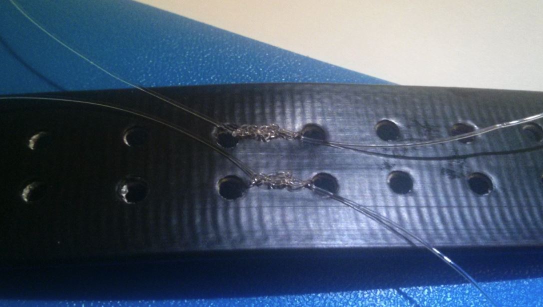
Hi Jackson,
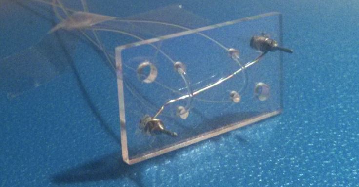
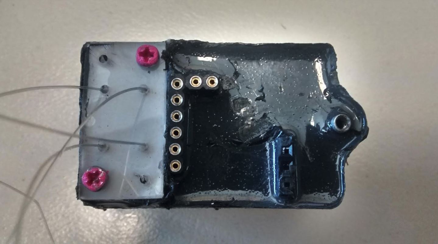
Attached a few images showing how we attach the koala drop-off to collar material. The first shows the bare nichrome-acrylic plate with the nylon line in-situ. There's also a picture of an actual koala drop-off with the line exiting the plate. Lastly, the triple overhand knots (repeated so the knots are doubled over and secure) tying the line through the collar material. Normally, we hide the nylon by splicing the collar material in half, tying the knots, and then gluing the collar material back together so no nylon is exposed.
Does all that make sense? Any questions just let me know.
Cheers,
Rob
19 April 2019 7:55am
also, we noticed our BoM was missing from GitHub, so we've added it now: https://github.com/Wild-Spy/OpenDrop/blob/master/Documentation/OpenDrop_BOM.xls
5 March 2020 4:44am
the drop off paper
https://besjournals.onlinelibrary.wiley.com/doi/10.1111/2041-210X.13231
#Tech4Wildlife 2020 Photo Challenge In Review
4 March 2020 12:00am
Accepting Applications: ArcGIS Solutions for Protected Area Management
4 March 2020 12:00am
Call for Nominations: Tusk Conservation Awards

3 March 2020 12:00am
Open-Source Argos Developer's Kit / Tag
2 March 2020 10:27pm
Hawai'i Conservation Conference
 Hawaiʻi Conservation Alliance
28 February 2020 12:00am
Animove Summer School 2020
 AniMove
13 February 2020 12:00am
Curious about radio-tracking with drones?

29 January 2020 3:44am

31 January 2020 8:26am
Hello Laura,
Thanks for the detailed response. It sounds like a very interesting use of drone technology.
Many thanks,
Mark

12 February 2020 1:50pm
Hi,
Does your system work with normal VHF tags or do you make a custom tag for use in your system?
Does the drone have to be piloted manually in a particular path or pattern in order to acquire the tags?
Or can your receiver be placed on say a fixed-wing high speed drone programmed to fly a lawn mower pattern to cover the maximum amount of area?
I'm also curious how you are doing the direction finding, since there are no visible antennas, but I understand if you'd rather not talk about this (c:
Interesting work, thanks.
-harold
12 February 2020 9:33pm
Thanks for asking Harold,
We work with any off the shelf VHF tag, you can use tags already in the field or you can order tags from any of the manufactureres, just have to be VHF of in the case of satelite or GPS tags have a VHF componment.
The drone is piloted manually, you can see the tag locations on the base station in real time you can reposition the drone to avoid terrain challanges to get the best results.
We cover a lot of ground, I can do the math, flight patterns really come down to the application you are looking at animal being tracked ect, happy to discuss specifics further at you convenience.
We have videos of our work on out youtube channel
https://www.youtube.com/channel/UCj1pcEJHkEPCy94AlT0U7HQ
The oringinal research papers are on researchgate
https://www.researchgate.net/profile/Debbie_Saunders
You can book a virtual demo with me, I'd love to hear about your work and ideas. It would be great to give you a run through of the solution, flight patterns and user interface.
https://www.wildlifedrones.net/book-demo/
Robert
Wildlifedrones
robert@wildlifedrones.net
+61 491 625 411
Number of radio collared animals?

9 December 2019 7:27pm

4 January 2020 10:58pm
There are over 7000 tracked animals via Argos alone (monthly). More info here - http://www.argos-system.org/applications-argos/wildlife-monitoring/

5 January 2020 10:49am
Thanks Alasdair
So there are low double figure thousands just with the various services of satellite collars. Then surely high tens of thousands, maybe low hundreds of thousands with terrestrial GPS and conventional VHF.
Radio telemetry
4 June 2019 4:39pm

5 June 2019 11:33am
Hi Helen,
Two suggestions coming through over twitter:
A good start is to reduce your reciever's gain as far as possible.
Hopefully you can snuff out the antenna's rear lobe that way. Headphones really help there too. https://t.co/9Eg4gpHVly
— Faunatech Austbat (@FtechAustbat) June 5, 2019
sometimes it helps to put your body behind the antenna at about waist height. Does that make sense?
— Rob Appleby (@wildspyrob) June 4, 2019
Steph
18 December 2019 4:00am
Hi Helen, what tags are you using? Position on the animal and what species?
24 December 2019 5:07pm
HI there,
Biotrack combined Avian GPS SOB tag & PicoPip AG317 Tag on the back of Hawfinch.
H
WILDLABS Virtual Meetup Recording: Drones
 WILDLABS Team
9 November 2019 12:00am
Studying pangolin ecology
16 April 2019 3:59pm

21 October 2019 3:26pm
Hi all, many thanks for the information.
21 October 2019 11:42pm
Hi all,
Great to see this post continue to mature. Some good news for you all. Arribada has finished developing a lower cost open source Argos ARTIC R2 transmitter design with our development partners Icoteq for a National Geographic project. All thanks to @ThomasGray_Argos who originally gifted us 3 R2 development chips to work on an open reference design.
It's compatible with the Arribada Horizon GPS tracker, or cellular module if both are required in one device / unit. We'll look to integrate one of the LoRa radios from the Open Collar initiative too to create a comprehensive open solution that can be tweaked to form a viable pangolin tracker based on the attachment and epoxy designs above (thanks for the paper @Robin+Poches , great research).
However, first up is Bangladesh for some open ocean plastics tracking.
More info here for now - https://www.icoteq.com/icoteqs-argos-satellite-transceiver-now-certified-by-cls/
Cheers,
Alasdair
22 October 2019 3:40pm
Fantastic news, Alasdair. Indeed timely. I was wondering what the finiancial impliation for one unit will be? A price range will suffice. Thanks.
C
Wearable Tech Lions - Current Projects
17 October 2019 10:23am
18 October 2019 3:45am
Hi Natalie,
Interesting request. I may be able to help and am working in this area in Australia to track both native and introduced species. Would you please enlighten me with more specific objectives, location, duration and quantity.
Thanks.
Using Artificial Intelligence to Track Birds’ Dark-of-Night Migrations
9 October 2019 12:00am
28 April 2020 5:09pm
@Sophie+Maxwell
One point of clarification - Kineis is Argos.
CLS split off the management of the Argos satellite system from itself thereby creating the company called Kineis (a subsidiary of CLS). Kineis' goal was to acquire enough funding ($100m) to launch the 20+ nanosatellites by 2020, and the goal was fully funded a number of months ago. So now it's just a matter of manufacturing the satellites and launching them (one is already in orbit).
I would disagree with your comment about "antenna size issue" with Argos because you can use a patch or a whip antenna. In addition, the whip antenna could be extremely thin and flexible such as using nitinol. With nitinol, for example, you can tie a knot into the antenna, and it would return to its regular state once undone. Of course with a whip antenna you do have a long wire coming out of the tag; however, that can be addressed with a patch antenna for terrestrial applications. Thus, it offers a flexible solution.
I will also add that you can fill in those data gaps and in fact build a "terrestrial-like" network within the Argos framework by deploying a number of the Argos Goniometer stations. In that scenario you would have a tagged rhino transmitting to the Argos satellites, and as you know if a satellite is not overhead the message is lost. However, if there is an Argos Goniometer within range (tens of miles +/-) you will receive that message even if a satellite is not overhead.
One last comment that I'll add is that the power requirements for an Argos transmission are a fraction of what is required from Iridium and/or Globalstar. Right now the lowest power output that I am aware of is 250mW; however, we expect to more than half that when the constellation is launch (70-100mW transmissions). I am not that familiar with some of the new sat tech in regards to transmitter design, output, etc. I suppose the one good thing about having an "old system" is that we know so much more about what can be done and what cannot be done.
Anyways, happy to answer any questions you might have regarding Argos and/or Iridium.