Group curators

Talia Speaker
- @TaliaSpeaker
- | She/her
WILDLABS
World Wide Fund for Nature/ World Wildlife Fund (WWF)

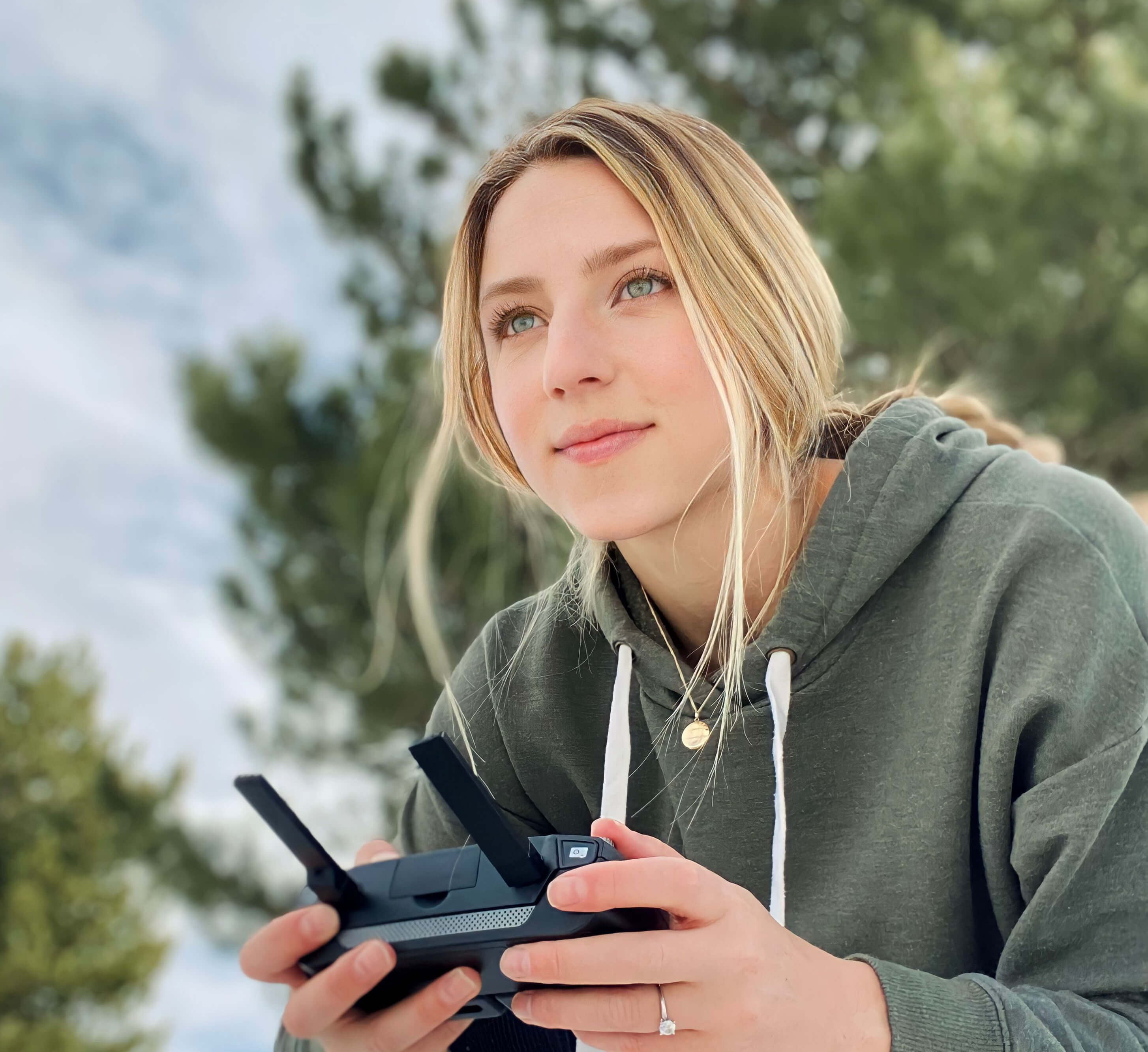
Lacey Hughey
- @lhughey
- | she/her
Smithsonian Conservation Biology Institute
Animal movement technologies have already significantly advanced our understanding of the natural world, from uncovering previously mysterious migration patterns and key movement corridors to demonstrating the impacts of anthropogenic pressures and climate change. Continuing advances in the development of technologies for collecting and transmitting bio-logging data, combined with the increased availability of high-resolution environmental data and analytical developments in movement modelling, are opening doors to novel applications. However, there are still major gaps in the space, including mobilizing movement data to translate data from tracking devices into insights for application in policy and practice. This group is a place for the animal movement community to connect and discuss our efforts to advance the field.
Resources for beginners
Learn about WILDLABS Animal Movement research projects
- MoveBON Initiative Announcement
- MoveBON Follow-Up Discussion
- Virtual Meetup Season 4: Tracking Progress (A WILDLABS research project on movement ecology)
Group curators
- @TaliaSpeaker
- | She/her
WILDLABS & World Wide Fund for Nature/ World Wildlife Fund (WWF)
I'm the WILDLABS Research Specialist at WWF-US


- 23 Resources
- 62 Discussions
- 25 Groups
- @lhughey
- | she/her
Smithsonian Conservation Biology Institute
I am an ecologist and program manager with experience leading collaborative research projects in international settings. I specialize in the application of animal tracking data to conserve migratory species on a changing planet.


- 6 Resources
- 10 Discussions
- 3 Groups

- @emmacbto
- | She / Her
Research Ecologist and Survey Organiser | Wetland and Marine Research Team | BTO
- 0 Resources
- 0 Discussions
- 2 Groups

- @Adamtours
- | He
I am a 25 year old swedish citizen but have lived in Southern Africa my whole life with a big heart and passion for conservation and wildlife and getting more interested in conservation and the tech available that would be a benefit to the wildlife and spaces needing protection
- 0 Resources
- 1 Discussions
- 2 Groups

Sea Mammal Research Unit Univ' St Andrews
I work in marine bioacoustics with a focus on the conservation of marine mammals. Most of the time I'm developing and using passive acoustic technology to study the underwater behaviour of dolphins and porpoises. I'm also a keen developer on the PAMGuard project.


- 0 Resources
- 23 Discussions
- 6 Groups
World Wide Fund for Nature/ World Wildlife Fund (WWF)
- 0 Resources
- 12 Discussions
- 15 Groups

WILDLABS
This account is managed by the WILDLABS Team. Tag us or DM whenever you need help from our community team.


- 22 Resources
- 23 Discussions
- 11 Groups
- @apcxs
- | He, his, them
- 0 Resources
- 0 Discussions
- 11 Groups

- @Helga_Kuechly
- | she/her
World Wide Fund for Nature/ World Wildlife Fund (WWF)
I am a Geo-ecologist, who loves to use GIS, remote sensing, citizen science and knowledge transfer to shape for a better future for nature - We are part of nature, so let's act like it!
- 2 Resources
- 1 Discussions
- 8 Groups

Director of Icoteq Ltd, an electronics and software design consultancy developing wireless products and solutions to organisations working in the conservation, wildlife monitoring and anti-poaching sectors. Developers of the TagRanger® novel wildlife tracking products.


- 1 Resources
- 14 Discussions
- 7 Groups
We are among the first in Bolivia to use GPS technology to monitor wildlife after release, focusing on ensuring successful reintegration into natural habitats. Our work combines rescue, rehabilitation, and reintroduction efforts.
- 0 Resources
- 1 Discussions
- 1 Groups
Department of Parks and Wildlife (Western Australia)
- 0 Resources
- 11 Discussions
- 2 Groups

Holder of BSc in Applied Zoology. Assistant Ecologist at Ruaha National park.


- 0 Resources
- 7 Discussions
- 12 Groups
University of Zurich
PhD student at the University of Zürich (CH) in PopEcol group, working with camera traps and mammals
- 0 Resources
- 0 Discussions
- 8 Groups
Link

Biodiversa+ is running a survey to map the European biodiversity monitoring landscape, identify opportunities for collaboration, and strengthen coordination for improved monitoring.
7 May 2024
Article
The Inventory User Guide

Jake Burton
Read in detail about how to use The Inventory, our new living directory of conservation technology tools, organisations, and R&D projects.
1 May 2024
Article
Introducing The Inventory!
Jake Burton
The Inventory is your one-stop shop for conservation technology tools, organisations, and R&D projects. Start contributing to it now!
1 May 2024
Careers
The Smithsonian National Zoo & Conservation Biology Institute is seeking a Program Manager to help coordinate multiple organizations in an effort to integrate movement data & camera trap data with global...
22 April 2024
Careers
Postdoc: Biologging & Camera Trap Data Integration

Lacey Hughey
The Smithsonian National Zoo & Conservation Biology Institute is seeking a Postdoctoral Research Fellow to help us integrate movement data & camera trap data with global conservation policy.
22 April 2024
Article
The Variety Hour: 2024 Lineup

Alex Rood
You’re invited to the WILDLABS Variety Hour, a monthly event that connects you to conservation tech's most exciting projects, research, and ideas. We can't wait to bring you a whole new season of speakers and...
22 March 2024
Careers
Hussey Labs seeks a senior post-doctoral researcher/senior research associate for movement ecology of Greenland halibut in the context of fisheries management across Baffin Bay-Davis Strait, Eastern Canadian Arctic.
13 March 2024
Article
Catch up on the conservation tech discussions and events that happened during World Wildlife Day 2024!
7 March 2024
Article
Firetail - updated price model from 03/2024
Tobias Petri
more affordable pricing for our software for the visualization and annotation of GPS and acceleration data
4 March 2024
Careers
Seeking a doctoral student to join the Move.inFormation research group in an exciting new project investigating the use of social information for optimal movement in the Andean condor.
12 February 2024
Careers
PhD position: Foraging in the landscape of peril
Milos Jezek
Research topic: Pathogens and predators represent the ultimate and ubiquitous threats to fitness. One of the defense counter-strategies is behavioural avoidance of the cues of infection risk (disgust) and predation risk...
10 February 2024
Careers
The primary focus of the research is to explore how red deer movements, space use, habitat selection and foraging behaviour change during the wolf recolonization process.
10 February 2024
July 2025

August 2025
October 2025
event
Lacey Hughey and 3 more
November 2025

November 2023

91 Products
Recently updated products
| Description | Activity | Replies | Groups | Updated |
|---|---|---|---|---|
| Hi Vivian,Thank you so much for your reply! I appreciate the pointers on species mixing, to clarify: I have been experimenting with deer data, but for once the project is underway... |
|
Animal Movement | 23 hours 39 minutes ago | |
| Hi Ethan, It's indeed a competitive area. My advice for you (and anybody else seeking a PhD supervisor)...Do background research on each individual potential supervisor and always... |
|
Early Career, AI for Conservation, Animal Movement, Climate Change | 4 days 9 hours ago | |
| Hi Thomas, Thanks for your input. It is helpful to get that sort of info as I am not so familiar with the topic and just starting to understand the vast array of tagging... |
|
Animal Movement | 1 day 19 hours ago | |
| We are please to inform that we have implemented the point 1 and 4 and with this have finalized the project. The latest improvements:Improvement in findability of help... |
|
Animal Movement, Data management and processing tools, Software Development | 6 days 22 hours ago | |
| Hello everyone!My collaborators and I are trying to assess the extent to which animal movement ecology is currently being integrated into... |
|
Animal Movement | 1 week 3 days ago | |
| Wonderful video! Really impressive :) |
|
Animal Movement, Human-Wildlife Conflict, Latin America Community | 3 months 2 weeks ago | |
| My name is Frank Short and I am a PhD Candidate at Boston University in Biological Anthropology. I am currently doing fieldwork in Indonesia using machine-learning powered passive... |
|
Acoustics, AI for Conservation, Animal Movement, Data management and processing tools, Early Career, Emerging Tech, Ethics of Conservation Tech, Protected Area Management Tools, Software Development | 2 weeks 1 day ago | |
| Thanks Phil - I have e-mailed you.Peter |
|
Animal Movement, Sensors | 3 weeks 1 day ago | |
| Hi, we've gotten more than 20 replies until now so thank you if you took the time to answer.And we would really appreciate if you could spare a few minutes to answer if you haven'... |
|
Emerging Tech, Animal Movement, Build Your Own Data Logger Community | 1 month 1 week ago | |
| Reopenning this discussion again in case there is some news! |
+25
|
Animal Movement | 1 month 3 weeks ago | |
| Good morning JocelynThank you very much for your comment, this is proving to be very useful advice and thank you so much for setting me on the right path!! This is very exciting!!... |
|
Animal Movement, Citizen Science, Human-Wildlife Conflict, Marine Conservation, Drones, Community Base, Geospatial | 1 month 4 weeks ago | |
| Hi Nikita, If you haven't already, I'd recommend reaching out to the folks at the Cornell Ornithology lab. They're really glued into all things bird. In particular, I... |
|
Animal Movement, Drones, Emerging Tech, Human-Wildlife Conflict | 2 months ago |


Looking for opportunity to visit conservationists in Uganda

3 October 2019 2:19pm
Technology lab focused on wildlife protection opens on Ol Pejeta Conservancy
31 May 2019 12:00am
Technology for Wildlife and the Looming Spectre of E-Waste
3 May 2019 12:00am
9-axis sensors for tracking tiny animals
14 April 2019 12:19am

14 April 2019 11:53pm
Hi jjinsing,
You could take the 9 axis LSM9DS1 sensor from the Horizon tag (open source) + firmware and build a custom module. Your limitation will be the coin cell battery and switching to a smaller microcontroller to get the size and weight down. What's the weight of the hummingbirds? 11g odd?
There is a tarantular tracking project that requires a similar sized tag (bluetooth base stations to track), so if that gets built you could inherit that in the future. Htarold is correct in that actual location will need a local rfid / base station at the feeding station to know where they are and you'd be looking at behavioural and energetics logged to flash etc.
Cheers,
Alasdair

15 April 2019 2:36am
Hi Jay, Alastair,
Small world! You've got a great resource at your doorstep then (c:
Your idea of tracking the birds between known feeding locations is a good one, and it's made use of here. But I don't know if the drift will cooperate over that long a period. A colleague who looked into cheap accelerometers for navigation told me it doesn't work after 10 seconds or so. But this was some years ago and things may have improved. It might be possible to detect when a bird is stationary, to zero the device. This is like when a fireman puts his foot down in the above case.
Thanks,
-harold
Update on Arribada's Low Cost Open Source Sea Turtle Tag
12 March 2019 12:00am
#Tech4Wildlife Photo Challenge: Our Favourites from 2019

3 March 2019 12:00am
The OpenCollar Initiative
21 February 2019 12:57pm
OpenCollar for wildlife monitoring launches at The Things Conference
6 February 2019 12:00am
Drone based orangutan tracking

12 January 2019 6:51pm

14 January 2019 11:42am
Hi Dirk,
Your case study is an interesting read, thanks for sharing. In terms of people exploring similar things, there are a few members who you could connect with about different elements of the project. Your project has a few different elements - are there specific things you're interested in hearing how others are handling?
As a start:
- @Sol+Milne is working with Drones and Orangutans, but using them to map nests rather than track individual animals. Case study here, discussion about the project here.
- There's a discussion in this group about aerial platforms for wildlife tracking that might be relevant, which @Albin , @YvanSG , @Rob+Appleby and @emjay are involved in. In a spinoff thread, @emjay has shared the details of WildFInd, a package that produces geo-referenced heatmaps for VHF collared animals - sounds like this could be relevant for your project as you're using VHF implants as well, right? He's invited feedback to help move that project forward, so might be worth checking it out to see if it's relevant and there is overlap between your work.
- @Tomswinfield has been working with drones in Indonesia for the past few years to map forest recovery efforts (case study here - it's a bit dated but gives you an idea what he's exploring).
- @meganossmann has been testing out FLIR’s new Duo Pro R thermal camera as a detection tool for loggerhead sea turtle nests (case study here, discussion here).
This is by no means an exhaustive list of members working in this space, but it's a enough to point you in the direction of some of the recent work being shared here that seems to overlap with what you're working on.
If you haven't already, I'd also recommend having a poke around our drones group as well as there might be some relevant discussions/projects that could be of interest.
Steph
14 January 2019 11:06pm
Hi Dirk,
Sounds like an absolutely fascinating project and well done on all the progress you've made! If you aren't already aware of it, I think the Sensorgnome system people and you have some definite things to chat about. Sensorgnomes use Pis/Beaglebones and RTL-SDRs (or FUNcubes) and custom written software to automatically tracking beacons. The system is primarily used for ground stations, and there's a lot of emphasis on the small Lotek coded VHF tags, but conventional tags also work and there's a lot of interest in the community about drone tracking as you'd expect. Anyway, great stuff and welcome to WILDLABS!
Cheers,
Rob

16 January 2019 11:59am
Thanks all, very useful links, some of them, like the orangutan nest mapping, wildfind, & sensorgnomes, I knew about, some not. Will have a poke :)
Integrating GPS trackers and accelerometers to examine the movement ecology of possums in fragmented landscapes

20 December 2018 10:12pm
WILDLABS Virtual Meetup: Networked Sensors for Security and HWC Prevention
 WILDLABS Team
12 November 2018 12:00am
WILDLABS Virtual Meetup Recording: Next Generation Wildlife Tracking
WILDLABS Team
12 November 2018 12:00am
WildFind - a package to produce a georeferenced heatmap of VHF collared animals.

23 September 2018 10:50am
6 November 2018 10:20pm
Hello Mike
If I understood your system description correctly, you intend to analyse the radio data and produce the heatmap on board the drone. Why ?
I would do minimal data processing onboard, log any relevant details onto removable memory such as an SD card and do all further processing offline on a PC.
This should dramatically reduce the energy and processing demands of your drone-based hardware and simplify the software, too.
I guess there must be (open source?) solutions available that can convert data in a suitable format into a heatmap. This should save you having to re-invent that wheel.
Hope this is of some use.
Good luck,
Joachim Neff
8 November 2018 9:25am
Thank-you Joachim,
Yes- that will probably resolve one of the issues.
I think the larger issue that Al was trying to deal with was related to the 'ghost' data that caused the noise in the data.
Perhaps the issues are related?? Maybe a logger rather than processor might reduce the errant frequencies that we were observing.
MJ
8 November 2018 12:45pm
Hello Mike
I am not sure whether a datalogger would resolve radio noise problems. I would expect more success from improving the antenna/receiver circuitry to get rid of the noise before you digitise/record. Unfortunately, I can't give you much advice on this subject but antenna/circuit design can be tricky.
I just watched your YouTube clips and noticed in the last clip that there seems to be a 40 dB margin between the transmitter signal and the background noise. Based on my limited experience, this should be plenty to clearly separate signal from noise. With the right type of signal conditioning/filters you should be able to log only the signal you are interested in. Record this together with the current location coordinates and you should get close to the data set you need for producing the heatmap.
Good luck,
Joachim Neff
Tiny tags and a broad research network help track small animal movements
31 October 2018 12:00am
Developing the Next Generation of Animal Telemetry Webinar
22 October 2018 2:19pm
Tracking poop... (and therefore seed dispersal)
30 October 2017 7:15pm
30 November 2017 2:58pm
Hi Chris,
Interesting challenge! Over on twitter, Ian Redmond has a suggestion:
What makes #elephants such important #GardenersoftheForest is that the #seeds pass through the gut undigested, ready for #germination miles from parent plant. How about acid-proof radio-transmitters in crush-proof pseudo-seeds that you insert into ripe fruit where eles forage? https://t.co/Q5skY90Jne
— Ian Redmond (@4Apes) November 30, 2017
What to you think? I'd be interested to hear from any of our engineers, would this sort of approach be feasible?
Steph

27 September 2018 10:16pm
Just to close this issue - I developed some iButtons and radio trackers which could be encased in medical safe epoxy and inserted into fruits for consumption by elephants. Unfortunately our focal elephant was very fussy... and she spat out all of the seeds in her fruits! Luckily she happily ate colour plastic beads... so we used those to calculate gut passage times. Sometimes the old school methods are the best methods!
Microwave Telemetry free tags
26 September 2018 1:37pm
Solar balloon to better track wildlife

3 September 2018 10:31am
20 September 2018 2:12am
Hi Albin,
I have attempted this (see videos below). We only had one day to trial the systems and predictably the winds were not in our favour.
I used the kit from the Public Lab weather balloon. https://publiclab.org/wiki/balloon-mapping
and we built the picavet along with tracking hardware. Was very DIY!
https://www.youtube.com/watch?v=Iy4z1vGHkyY
https://www.youtube.com/watch?v=9b3RnsoK3P8
Happy to answer questions.
regards,
Mike
20 September 2018 11:29am
Hi Mike,
Well, I thoroughly enjoyed both videos, particularly the second one - 'if only we had that sixth balloon, hmm?'.. Amazing.
On a more serious note - any chance you wrote anything up to accompany the videos?
Steph
20 September 2018 1:03pm
Thanks Steph,
No write-up. This little experiment was squeezed into some actual work. Very happy to describe components if someone is interested.
The balloon hobby project morphed into an UAV project using Software Defined Radio dongle as the VHF receiver.
I'm reluctant to hijack Albin's thread here other than to say that I should write something about the Wildfind project and note Al Brown's huge contribution to the work. He did the software, I just created the problem and a half-baked solution.
https://eartoearoak.com/software/wild-find
MJ

Telemetry spanish online course from Spain
19 September 2018 2:50pm
Next Generation Animal Tracking Ideation Challenge

14 September 2018 12:00am
Mataki-LITE: lessons learned from petrel tracking (Part II: Base-stations)

6 September 2018 7:13pm
6 September 2018 7:15pm
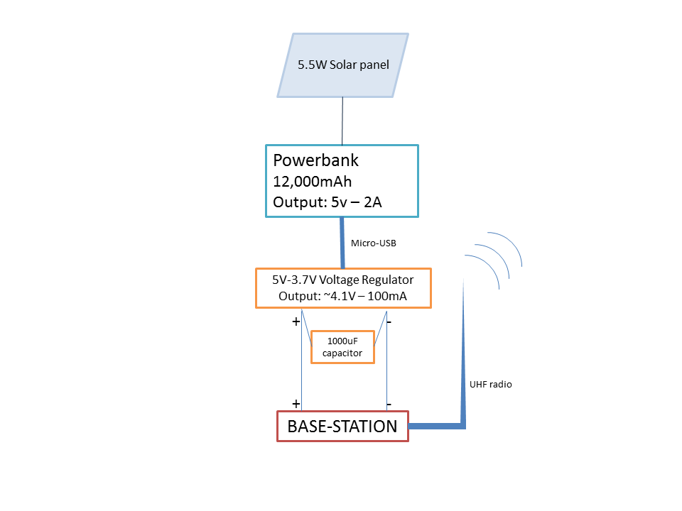
Power: Given the remoteness of Diablotin’s nesting sites (30 miles from the coast, ~2,000m above sea level, in the Sierra de Bahoruco National Park, Dominican Republic), I needed to rely on gear that easily be transported and adapted in the field (with limited access to electricity), withstand fog, rain and humidity, was allowed on international flights (cheaper than shipping to the Dominican Republic), could and was as cheap as possible. To power the base-stations, I chose Li-ion powerbanks as they are allowed on regular flights and (unlike car batteries) are easy to transport and affordable. Most regular powerbanks, though, have a safety feature that stops sending power when the device they recharge does not draw enough current: this is to avoid over-charging a fully-charged device. Since the Mataki-CLASSIC base-station draws very little current, typical powerbanks stopped after a few minutes. For this reason, I used Voltaic Systems’ V44 battery packs as their “Always On” feature is designed for low-power IoT.
Circuit: Since the battery’s 12,000mAh weren’t sufficient to keep the base-station safely running for the tracking period I needed (~ 1 month, at 480mAh per day), I paired it with a 5.5W solar-panels. The circuit was minimal (attachment 1): the solar-panel recharged the V44 battery, which delivered 5V-2A in “Always-ON” mode. The 5V-3.7V step-down regulator connected the battery to the base-station, in parallel with the 1,000µF capacitor.
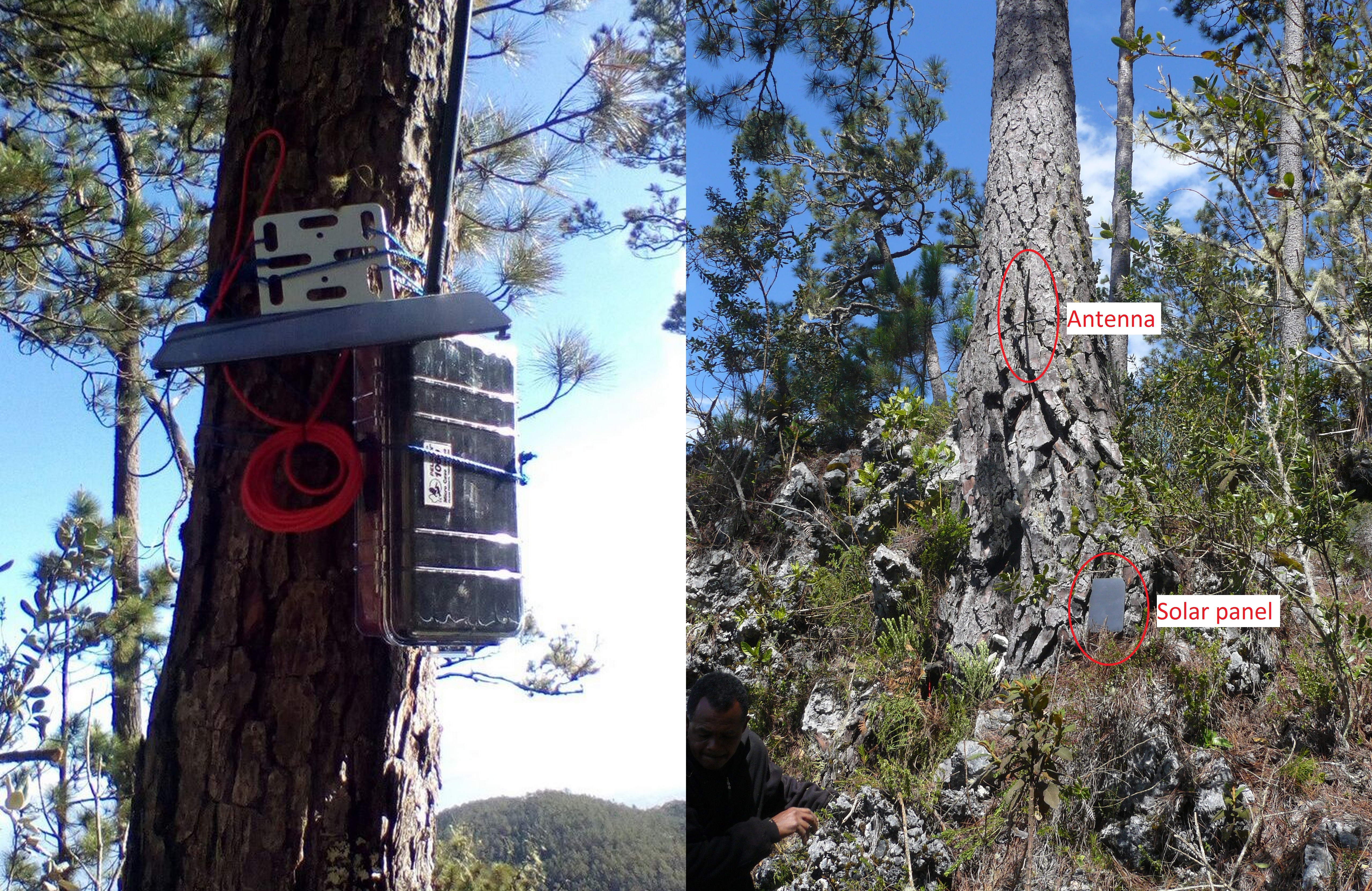
Antenna: Given the dispersion of the nests of tagged petrels, I chose an omnidirectional antenna. A directional, Yaggi-antenna could have been helpful for downloads from a distant vantage point, had the nests been clumped together. Each antenna had a maximum range of ~300m in open terrain but irregular relief and dense vegetation decreased that distance to ~100m. Note that in our region, the authorized UHF channel for private communications is 916mHz – this frequency might be different in other regions.
Enclosure: I enclosed the base-stations in a very simple version of this waterproof solar battery case, using a 1040 Pelican case: I trusted Pelican cases to have a good quality/price ratio. The battery barely fitted inside the case (I had to shorten the male 5.5x2.1mm input plug). While I still drilled a hole in the case, I didn’t use the M60 nut. Instead, I covered the hole and the cables (for the antenna and solar-panel) with Sugru and waterproofed them with 2-part epoxy: this allowed me to adapt the base-station more easily to the local conditions. For good measure, I also added a handful of desiccant packs into the case. Finally, I deployed the base-stations in open canopy, as close to the nests of the Black-capped petrels we tagged as possible. I tried to position the solar-panel to face the midday sun, a time when the morning fog had already burnt off but the afternoon clouds not yet rolled in (attachment 2: Deployed base-stations).
6 September 2018 7:20pm
Results: When we picked them up after a month and a half in the field, the base-stations had worked perfectly for the whole time. The battery levels stayed fairly consistent at >4.8V and with an individual range of about 0.5V. The panels positioned in full sun actually over-compensated the continuous power draw from the base-station.
Only a third of the deployed loggers had communicated with their respective base-stations but this could have several causes that were independent from the base-stations: logger battery life, waterproofing, attachment method; petrels staying at the nest for periods that were too short to communicate with base-stations; burrows that were too deep to allow radio waves.
I hope this will be useful, and please keep adding to the conversation.
Cheers,
Yvan
Mataki-LITE: lessons learned from petrel tracking (Part I: GPS loggers)
6 September 2018 7:00pm
6 September 2018 7:04pm
Discussion:
- Data recording rate:
1) Attachment location: It is likely that our attachment location on the underside of the tail had a negative impact on the recording rate. To avoid rectrix breakage and undue bouncing when flapping, we decided to center the loggers’ weight as close to the base of the tail as possible: loggers placed on top of the tail would have covered the uropygial gland therefore we chose to attach them on the underside, between the undertail coverts and the rectrices, with the GPS antenna pointing up.
2) GPS fix time: The location of GPS satellites at the time of recording might have prevented successful logging. Indeed, while GPS devices used by the general public have an ample supply of power that allows them to always be in communication with the network’s satellites (“hot start”), low-power wildlife tracking devices only activate GPS communication at the time of logging (“cold start”). Thus the amount of time required for a successful GPS logging (which is limited a priori to optimize power consumption) is affected by the location of GPS satellites at the moment of the cold start. The 4-minutes limit on GPS fix might have been to short.
6 September 2018 7:08pm
- Data recovery rate: Several possibilities exist for the lack of transmission:
1) Waterproofing failure: tests were performed to ensure that the waterproofing technique used in this study was resistant enough to sustain repeated immersions.
2) Death of tracked bird: The chicks of all tracked petrels were observed alive and in good condition in two visits in June and July, suggesting that tracked birds did not die during the tracking period.
3) Early loss of logger: Though the type of tape attachment I used in this study (which I reinforced with epoxy and a zip-tie) has been successful with other seabird, it is possible that rectrices broke off. I chose this technique instead of a dorsal attachment to keep the loggers from rubbing against the roof of rocky burrows, and to avoid the possibility of entanglement in hanging roots.
4) Early drain of logger battery: Remote-download GPS loggers such as Mataki-LITE have two main drains of power: 1) activating the GPS module to listen to communications from the network’s satellites, and 2) using the UHF radio to communicate with the base-station and, later, upload tracking data. I had written the logging script to optimize battery use through a geofence and a low-voltage mode. Based on recovered tracking data, it appears that none of the functioning loggers had entered the low-voltage mode during the ca 10 days at-sea though two of them had battery levels below the low-voltage threshold at the time of uploading data to the base-station (Table B.2). Since logger battery levels are only recorded when they send a heartbeat to the base station, it is unclear if these low battery levels had been reached earlier during the tracking period without triggering the low-voltage mode, had triggered the low-voltage mode but GPS data were not recorded, or resulted from a power drain due to radio communications.
5) Not enough time within range of base-station: It is possible that the loggers that did not transmit tracking data were not able to contact their respective base-stations despite having sufficient battery voltages. Radar surveys and camera-trapping at breeding colonies showed that Black-capped Petrels may reach speeds up to 70km/h when arriving at colonies and enter their burrows instantly. Upon leaving the nest, petrels stay <5 minutes outside the burrow. Pre-deployment trials showed that loggers placed at a burrow’s entrance were able to communicate with base-stations but loggers placed inside a burrow’s tunnel were not. The 2-minute heartbeat activated inside the 25-km geofence to optimize power should have been sufficient to upload tracking data but loggers that had failed to trigger the 25-km geofence (or that had already entered the low-voltage mode) were less likely to be within range of the base-station (~200 m) for long enough to send a successful heartbeat.
6 September 2018 7:09pm
Recommendations:
Mataki-LITE tags have a steep learning curve but they very adaptabile and cheap (for remote-download tags) so I hope these lessons-learned will prove useful for everybody.
- Future deployments may benefit from an attachment above the tail, ensuring that the uropygial gland is not covered; to avoid undue stress to the rectrices, the center of gravity of the logger should be as close to the rump as possible. Try dorsal deployments on birds nesting in large sod burrows.
- Although it is possible to extend the time period allocated to successfully log a GPS location, this would drastically increase power consumption. Therefore, try to improve attachment location before extending the GPS “ON time”.
- Simultaneous logging of GPS locations and battery levels, and GPS logging frequency may have to be decreased to optimize power consumption.
- Wider geofence radius and a higher heartbeat frequency in low-power mode.
Feel free to start the conversation and share your own scripts, deployment techniques and fixes!
Thanks,
Yvan
Solar balloon to better track wildlife
3 September 2018 10:25am
Spacewalk for ICARUS
24 August 2018 12:00am
RSPB Project Puffin Story Map
23 August 2018 9:08pm
How to share data on species to help conserve them… whilst avoiding them being exploited by poachers
20 August 2018 12:00am
Ocean Hack: San Francisco, 10-11th September, 2018
 One Ocean Collab
20 August 2018 12:00am
Journal of Animal Ecology: Open Call for Biologging Papers

13 August 2018 5:06pm
Using crowd-sourced funding to track snakes
30 July 2018 12:00am
Tracking tags/collars survey - WWF Cons Tech Programme
8 November 2017 11:06am
13 April 2018 5:02pm
Hi All,
If you've not already please do complete the above survey. Results and kudos will be shared widely!
Thanks and best, Paul
12 July 2018 6:39am
Hi Everyone,
This survey is still open so please check it out if you haven't already. We are right below 200 participants, it would be great to boost that! Below is one example results, lots more to come, we'll share all results when its done.
thanks
Roland
12 July 2018 8:07am
Hi Roland,
Thanks for the update - great to hear how many responses you're at and get a hint of the results. Any word on when the survey might be closing?
Steph
14 April 2019 7:02pm
Thanks Harold for the clarification on the accuracy of the sensor! Sounds like this isn't where it needs to be for accurate location tracking. I live just down the streen from Diginal Naturalism Labs, Andy is wonderful. Right now I have a network of 20 feeders all over our town which read implanted RFID's of visiting hummingbirds. Our thought was that maybe we could use a temporary glue to attach one of these to the back of a bird, and knowing the exact feeder location and time would allow us to calculate the amount of drift. If feeders were visited often the could be used as recallibration points to reset drift.
Anyways, thank you again for the input. Even if the location tracking aspect doesn't work, tracking the levels of activity would be super interesting! I'll probably start with that :).