Group curators

Vance Russell

Ahmed Junaid
- @ahmedjunaid
- | He/His

Elsa Carla De Grandi
Fauna & Flora
Who We Are
Geospatial data and analysis is critical for conservation, from planning to implementation and measuring success. Every day, mapping and spatial analysis are aiding conservation decisions, protected areas designation, habitat management on reserves and monitoring of wildlife populations, to name but a few examples. The Geospatial group focuses on all aspects of this field, from field surveys to remote sensing and data development/analysis to GIS systems.
How to Get Started
Want to learn more about how remote sensing is used in conservation? Check out the first two episodes of this season of Tech Tutors, where our Tutors answer the questions How do I use open source remote sensing data to monitor fishing? and How do I access and visualise open source remote sensing data in Google Earth Engine? You can also check out our Virtual Meetup Archive for a range of panels that overlap with Geospatial topics, or take a look at our Earth Observation 101 lecture series from Dr. Cristian Rossi.
Our Purpose
The WILDLABS Geospatial Group is for conservation practitioners, geospatial analysts, and academics that want to:
- Share geospatial resources, best practices, data, and ideas;
- Network amongst geospatial and data practitioners;
- Create peer learning opportunities;
- Promote the use of free and open-source geospatial software; and
- Improve the use of GIS software and geospatial analyses in conservation management and research.
Group curators

Over 35 years of experience in biodiversity conservation worldwide, largely focused on forests, rewilding and conservation technology. I run my own business assisting nonprofits and agencies in the conservation community


- 5 Resources
- 62 Discussions
- 12 Groups
- @ahmedjunaid
- | He/His
Zoologist, Ecologist, Herpetologist, Conservation Biologist


- 63 Resources
- 7 Discussions
- 26 Groups

Fauna & Flora
Remote Sensing Scientist, Conservation Technology & Nature Markets @ Fauna & Flora - WILDLABS Geospatial Group Co-Lead

- 34 Resources
- 28 Discussions
- 8 Groups
- @eleanorhorvath
- | she/her
Water Daughter
- 0 Resources
- 0 Discussions
- 10 Groups

- @Saratha
- | he
I am Saratha Sandeepa, with a B.Sc. Hons. (UG) in Surveying Sciences from Sabaragamuwa University of Sri Lanka (SUSL), specializing in hydrographic surveying, and a BBM (UG) from Uva Wellassa University, Sri Lanka (UWU). I hold a PADI Open Water Diving license and have a passion
- 0 Resources
- 0 Discussions
- 1 Groups

- @APooran
- | She/her
- 0 Resources
- 0 Discussions
- 9 Groups
- @Jen_NZ
- | she/her
- 0 Resources
- 2 Discussions
- 7 Groups

- @luciegallegos
- | she/her
Natural Solutions
As an agronomist engineer, I specialized in environmental management and resource conservation. 🌍 Interested in developing solutions for biodiversity conservation #indicators #monitoring
- 0 Resources
- 6 Discussions
- 10 Groups
- @capreolus
- | he/him
Capreolus e.U.
wildlife biologist with capreolus.at


- 1 Resources
- 78 Discussions
- 16 Groups
- @Margaret
- | Her/she
- 0 Resources
- 1 Discussions
- 8 Groups
- @Mateen
- | He, His, Him
- 0 Resources
- 0 Discussions
- 1 Groups
- @Jmortensen
- | he/him
I am a software engineering student making a career pivot from hands-on habitat conservation.
- 0 Resources
- 0 Discussions
- 4 Groups

Soil science, droughts effect of poverty, human rights advocate, wage equality in Europe, Drones in Digital Education


- 3 Resources
- 10 Discussions
- 19 Groups

- @Freaklabs
- | He/Him
Freaklabs
I'm an engineer and product designer working on wildlife conservation technology.

- 0 Resources
- 302 Discussions
- 20 Groups

I help conservation scientists spend less time on boring stuff.


- 0 Resources
- 53 Discussions
- 6 Groups
Link
Collaring Elephants and Post Release Monitoring
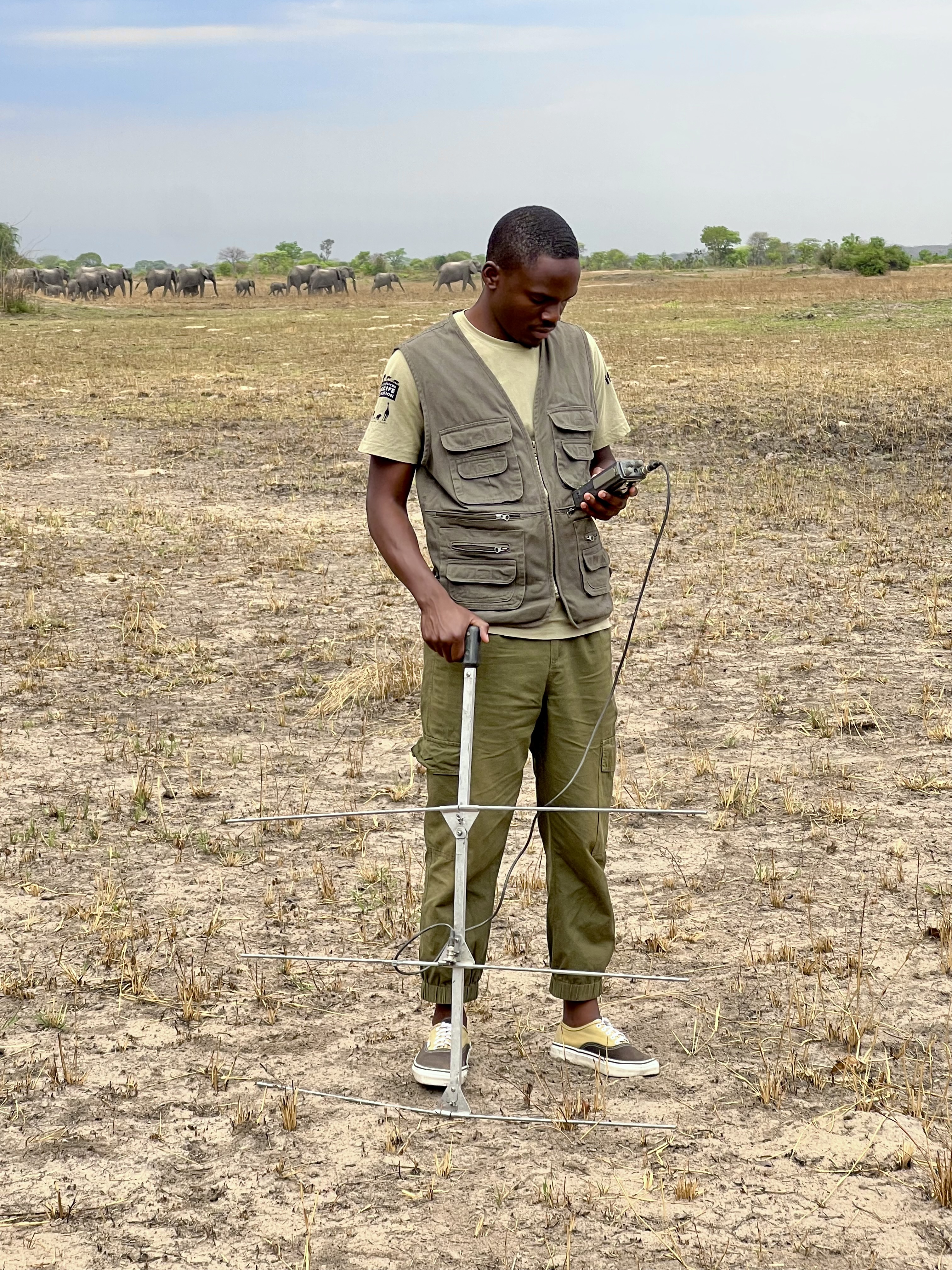
Kasi Amor Kalande
This leads to an exciting blog we did recently, it also includes a spatial map indicating elephant movement tracks of an orphaned elephant who self released himself into the wild (Kafue National Park). Cartography was...
28 January 2025
Careers
Geospatial Guru: Mapping a Better Future

Elsa Carla De Grandi
Remote, United Kingdom
27 January 2025
Link
Early Wildfire Smoke Detection Method Based on EDA

Ahmed Junaid
https://doi.org/10.3390/rs16244684
27 January 2025
https://doi.org/10.1098/rstb.2023.0327
26 January 2025
Link
Nature Climate Change (2025).
26 January 2025
Link

Updated version of the Spatial Database of Planted Trees (SDPT), which differentiates planted forests and tree crops from primary and secondary natural forests. Update has double the number of countries covered
25 January 2025
Link
New Data Provides First Global Annual Picture of Cultivated and Natural Grasslands

Elsa Carla De Grandi
The Land & Carbon Lab developed a new dataset that provides global maps of grassland extent annually from 2000 - 2022 at a 30 m resolution. These maps are critical for tracking changes in grassland ecosystems,...
25 January 2025
Article

Over the years, a large number of developments have gone up in the area that I live in and the municipality is not doing what they should when it comes to upholding the laws that have been put in place to protect the...
20 January 2025
Special Issue: Remote Sensing of Solar Radiation Absorbed by Land Surfaces
19 January 2025
Careers

The Department of Wildlife, Fish, and Environmental Studies (WFE), SLU, Umeå, is looking for a postdoc with strong interests in wildlife conservation technology.
15 January 2025
Link
Google Earth Engine Tutorial-100: Heatwave Mapping
Ahmed Junaid
Google Earth Engine with Amirhossein Ahrari
15 January 2025
June 2025
event

Joel Masselink
October 2025
event

Lacey Hughey and 3 more
November 2025

September 2024

August 2024
126 Products
Recently updated products
| Description | Activity | Replies | Groups | Updated |
|---|---|---|---|---|
| Things just got a whole lot easier for those of us at universities who train students to use drones as tools for conservation. Many... |
|
Geospatial | 9 years ago | |
| Another option is OruxMaps, free for android, not very intuitive but very powerful. But it's important to bear in mind that phone GPS accuracy can be lower than... |
|
Geospatial | 9 years ago | |
| ZSL is holding a remote sensing symposium on the 29th April, 2016: Space - the final frontier for biodiversity monitoring?... |
|
Geospatial | 9 years 1 month ago | |
| Hello all, This blog immediately make me think of our community and the possibilities for one of our members to provide a solution.... |
|
Geospatial | 9 years 2 months ago | |
| Thank you. I am doing pre reading and Information gathering, so I'll know what to expect and be prepared. Thank you for your kind answer Stephanie. |
|
Geospatial | 9 years 2 months ago | |
| Hello all - this paper looks highly relevant to this thread. "Satellite alerts track deforestation in real time: System uses... |
|
Geospatial | 9 years 2 months ago | |
| Advance Object-Based Classification of Delta Region Sindh. A project completed by COGE team. If you have any queries please contact :... |
|
Geospatial | 9 years 3 months ago | |
| Greetings all! I just received this invitation from Google. Feel free to distribute to your colleages. Applications due by March 15.... |
|
Geospatial | 9 years 3 months ago | |
| Learn how to use the power of storytelling for conservation in a special webinar on January 27th, hosted by Ryan Valdez of... |
|
Geospatial | 9 years 4 months ago | |
| Satellite imagery grants from the Digital Globe Foundation may be of interest to Remote Sensing group members: "The... |
|
Geospatial | 9 years 4 months ago | |
| ESRI's Conservation Program (ECP) grants may be useful to colleagues in the Remote Sensing group. It looks like ArcGIS.com... |
|
Geospatial | 9 years 4 months ago | |
| A couple of months ago I had the priviledge of attending the Geo for Good conference put on by the Google Earth Outreach team at Google HQ... |
|
Geospatial | 9 years 4 months ago |


Remote Sensing & GIS Group Leadership

8 May 2024 4:25pm
29 May 2024 5:43am
Hi Cathy, please check out what Alex sent and DM me if you're still interested in co-leading the group. Thanks.
Vance

31 May 2024 8:13am
Unfortunately I may fail to deliver so I cannot take it up. Am off net at times for two weeks straight.
But excited about everything GIS so I follow keenly.
Thank you for the explanation. 🤍

Samburu County Hazard Atlas
27 May 2024 6:31pm

Share Your Work in a Conservation Technology Video
17 May 2024 9:06pm
SCGIS Annual Conference: Conservation for Action
17 May 2024 7:30pm
The Inventory User Guide
1 May 2024 12:46pm
Introducing The Inventory!
1 May 2024 12:46pm

22 July 2024 10:55am

23 July 2024 2:05pm
23 July 2024 2:53pm
Hiring Chief Engineer at Conservation X Labs

1 May 2024 12:19pm
Delving into #tech4wildlife Innovation across East Africa with Sandra Maryanne & Catherine Njore
 CathyNj
and 2 more
CathyNj
and 2 more
30 April 2024 11:37am
Earth Blox dataset review: Meta Global Canopy Height (1m)

23 May 2024 7:23pm

27 May 2024 8:58am
Ecologist Postdoctoral Research Fellow
23 April 2024 4:32pm
Program Manager: Integrating movement and camera trap data with international conservation policy

22 April 2024 10:16pm
Postdoc: Biologging & Camera Trap Data Integration
22 April 2024 10:10pm
Starting a Conservation Technology Career with Vainess Laizer

16 April 2024 1:34pm
Applied hierarchical modelling (AHM) for species distribution and abundance
9 April 2024 7:22pm
Post Doctoral Research Assistant at ZSL

9 April 2024 7:03pm
ibm-nasa-geospatial (IBM NASA Geospatial)
28 March 2024 9:22am
ibm-nasa-geospatial (IBM-NASA Prithvi Models Family)
Foundation models and downstream applications for Earth Observation and Weather and Climate.

Catch up with The Variety Hour: March 2024
21 March 2024 7:39pm

21 March 2024 9:48pm

30 March 2024 3:08pm

31 March 2024 12:43pm
Leveraging Actuarial Skills for Conservation Impact
15 March 2024 12:31pm
19 March 2024 6:35pm
Thank you for your response Akiba. I will have a look. 👏🏻
19 March 2024 7:52pm
I would look into the TNFD (Taskforce on Nature-Related Disclosures), Finance for Biodiversity, Accounting for Nature, etc. which are all focusing on how to incorporate nature risk into corporate reporting and sustainability frameworks!
20 March 2024 3:48pm
Thank you Carly, I will definitely take a look.
Consultants - Mapping EU’s Marine Protected Areas and analyzing their ecological coherence
19 March 2024 9:39am
2 Postdoctoral Conservation Ecologist Positions at Smithsonian’s National Zoo and Conservation Biology Institute (SNZCBI)
14 March 2024 7:18pm
International Day of Forests: "New Technological Innovations are Needed to Halt Deforestation and Forest Degradation" Panel
14 March 2024 12:16pm
PhD Opening: Revealing the Dynamics of Soaring Environments Through GPS and Drones
13 March 2024 2:11pm
Ph.D. Assistantship: Collared Peccary Population and Spatial Ecology in Southern Texas
13 March 2024 1:51pm
Navigating corporate due diligence in the Voluntary Carbon Market
8 March 2024 4:36pm
26 March 2024 2:11pm
27 March 2024 10:56am
29 March 2024 9:13am
Machine Learning Postdoc Position, Understory
29 February 2024 11:56pm
Data data everywhere, but not a byte to use!
29 February 2024 7:13am
Engineer in novel technologies and approaches for biodiversity monitoring
26 February 2024 6:12pm
Scaling biodiversity scoring for supply chains aligned with TNFD
20 February 2024 9:44am
28 May 2024 5:42pm
Hi Cathy! Please check out the below article on group managers. Essentially, we're asking for a 12 month commitment of 1 hour a week (more or less) to promote engagement in WILDLABS groups by sparking conversations, engaging with people's content, and planning 1 virtual event a month to bring the community together. (This could be bringing a speaker in, or just having a 45 minute coffee call for people in the sector to get to know each other and share their work.)
As a group manager, you have the full support of the WILDLABS community team. We have a dedicated Slack channel, monthly calls to support you in your group management, and so much more.
Being a group manager is a great way to give back to the conservation tech community, steer conversations in the direction you think is important, foster a vibrant space for collaboration, and build your network. Shoot me an email if you're interested (alex.rood@wildlabs.net)! I'm happy to hop on a call to discuss more in-depth.