In recent years, drone technologies have been explored for a range of applications in conservation including (but not limited to) mapping, biodiversity inventories, antipoaching patrols, wildlife tracking, and fire monitoring. The rise of customizable, open-source drones like those of ArduPilot and OpenROV hold promise for more effective conservation applications, and combined with other monitoring sensors and devices, they are capable of collecting high-resolution data quickly, noninvasively, and at relatively low cost.
However, challenges remain in putting these tools to use. A recent paper reviewing 256 conservation drone projects highlighted some of these major obstacles, ranging from unintended social and ecological consequences of drone operations to still prohibitive costs, both in terms of hardware and in terms of storing and processing large volumes of data. The longstanding challenge of power/battery life remains as well.
If you're considering trying out drones for yourself, and want to explore the possibilities and understand the major conversations happening around this technology, check out these beginner's resources and conversations from across the WILDLABS platform:
Three Resources for Beginners:
- Conservation Technology User Guidelines Issue 5: Drones, World Wildlife Fund | Drones, best practices, ethics, regulations, case studies
- WILDLABS Virtual Meetup Recording: Drones, Craig Elder, Dr. Claire Burke, and Gabriel Levin | Drones, thermal camera, wildlife crime, ML, biologging
- New Paper: Drones and Bornean Orangutan Distribution, Sol Milne | Drones, data analysis, citizen science, community science, primates
Three Forum Threads for Beginners:
- Curious about radio-tracking with drones? | Wildlife Drones, Biologging (5 replies)
- Drones for GIS Best practice Document | Adrian Hughes, Drones (10 replies)
- WWF Conservation Technology Series: Drones in Conservation | Aurélie Shapiro, Drones (7 replies)
Three Tutorials for Beginners:
- How do I use a drone to capture radio-tracking data? | Debbie Saunders, Tech Tutors
- How do I choose the right drone for my conservation goals? | Shashank Srinivasan, Tech Tutors
- How do I strategically allocate drones for conservation? | Elizabeth Bondi, Tech Tutors
Want to know more about using drones, and learn from experts in the WILDLABS community? Make sure you join the conversation in our Drones group!
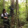
*Header photo: Parker Levinson, Point Blue Conservation Science
No showcases have been added to this group yet.

I'm a wildlife ecologist with interests in a range of technology.


- 0 Resources
- 22 Discussions
- 5 Groups
- @stienheremans
- | she/her
Remote sensing researcher for environmental monitoring and nature conservation/restoration
- 0 Resources
- 1 Discussions
- 5 Groups

Movement Ecologist studying the where, why, and how animals move throughout our world. Current work is investigating the movement and energetics of large neotropical bats in a changing environment with ephemeral resources.


- 0 Resources
- 23 Discussions
- 22 Groups
- @tomwhite101
- | He/Him
Agroecology Geek
- 0 Resources
- 0 Discussions
- 12 Groups

BSc Forest Engineering, MSc GIS Sciences, Drone researcher
- 2 Resources
- 11 Discussions
- 5 Groups

University of British Columbia
Postdoc at UBC, exploring how drones enhance wildlife conservation using thermal cameras & AI tools to refine monitoring of large mammal populations in Canada & compare these approaches to traditional methods.
- 0 Resources
- 0 Discussions
- 7 Groups

- @Fatuma
- | She/Her
I aim to transition my career towards conservation technology after gaining two years of experience in the tech industry.
- 0 Resources
- 0 Discussions
- 13 Groups

- @Heloise
- | She / Her
Bio-acoustician, marine biologist, marine mammal specialist, drone enthusiast
- 0 Resources
- 0 Discussions
- 9 Groups

- @DibblexLesalon
- | Mr
Dibblex Lesalon is the visionary force behind the captivating podcast, Boots on the Ground, he is the Creative Lead, embracing the power of one-on-one conversations to amplify the voices for conservation. A masterful host, he orchestrates compelling dialogues and seamlessly navig
- 0 Resources
- 0 Discussions
- 2 Groups
Researcher interested in waterbird ecology and conservation
- 0 Resources
- 1 Discussions
- 6 Groups

Royal Society for the Protection of Birds (RSPB)


- 1 Resources
- 18 Discussions
- 4 Groups
University of Salford
- 0 Resources
- 2 Discussions
- 6 Groups
This paper explores the use of UAVs equipped with thermal and standard cameras to accurately count the group sizes of the Critically Endangered cao vit gibbon, highlighting how this technology can overcome the...
13 June 2023
Link

AirSeed has developed a unique approach to tackle climate change and restore biodiversity by combining drone technology, machine learning, and seed pod biotechnology to carry out planting that’s 25x faster than...
30 May 2023
Link
Using computer vision to understand bee vision

Ellie Warren
Here's an innovative project from the Harvey Mudd College Bee Lab that could help us understand how bees view their environments, and thus better protect bee habitat. This project uses computer vision and drone imagery...
5 May 2023
Link
Researchers use taxidermy bird drones to monitor wildlife

Stephanie O'Donnell
Interesting project - “Our main goal for this is to develop a nature-friendly drone concept for wildlife monitoring,” Hassanalian said. “Traditional drones are often disruptive to ecosystems due to issues such as sound...
26 April 2023
Careers
Hardware Lead - Biodiversity / Conservation

Ben Williamson
New role at Pivotal Earth
4 April 2023
Article

New paper in Journal of Animal Ecology
24 March 2023
Link
We used a combination of high-resolution satellite tracking (Fastloc-GPS), uncrewed aerial vehicle (UAV) surveys, and capture-mark-recapture approaches to assess the abundance of immature hawksbill (Eretmochelys...
21 March 2023
Article

Discover how drones are revolutionising conservation efforts and learn five essential tips to fly responsibly and minimise harm to wildlife, humans, and the environment.
14 March 2023
Careers
Proposals wanted for Innovation in Practice
Ellie Warren
The Innovation in Practice edition of Methods in Ecology and Evolution is still seeking proposals about conservation technology
6 March 2023
Interesting article that links to research on how technology has made studying moose populations easier, with particularly good explanation of what makes moose populations difficult to track.
22 February 2023
Careers
The Environmental Robotics Lab at ETH Zurich welcomes applications for a postdoctoral fellowship on robotics methods for the collection of environmental DNA to automate monitoring of biodiversity in terrestrial...
12 February 2023
Link
How daredevil drones find nearly extinct plants hiding in cliffs
Stephanie O'Donnell
Nice article about one of the Rainforest XPrize semifinalist teams - using drones to sample plant species. 'Nyberg and the National Tropical Botanical Garden (NTBG) team, working with the State of Hawaii's Division of...
10 February 2023
August 2025
event

Louisa Richmond-Coggan
September 2025
event
Louisa Richmond-Coggan
March 2026

November 2023

33 Products
Recently updated products
| Description | Activity | Replies | Groups | Updated |
|---|---|---|---|---|
| Hats off to your team for this absolute game-changing technology! We rescue stray and wild animals in Taiwan, and the bulk of our work is saving animals maimed by wire snares... |
+37
|
AI for Conservation, Drones, Emerging Tech, Human-Wildlife Coexistence, Wildlife Crime | 8 months 3 weeks ago | |
| Adrian,Many thanks for v2.0 of the GIS best practices document. How does one obtain a copy of the RSPB code of practice B09 referenced in the best practices document? The link in... |
+8
|
Drones | 9 months ago | |
| Hi,I wonder if anyone could provide a synopsis of where drone tech currently sites for autonomous usage and AI implementation for surveys... |
|
Drones | 9 months 1 week ago | |
| No problem at all Yu (@JY) and good luck with your studies! Happy to discuss this and any other ideas any time.All the best,Rob |
+10
|
Sensors, Animal Movement, Connectivity, Drones, Open Source Solutions, Emerging Tech | 9 months 2 weeks ago | |
| 180m is indeed very high and from above. I think a 640x512 thermal sensor with a 70mm lens can see animals at at 180m from sideways and could recognise something as a deer, but... |
+11
|
Drones, Human-Wildlife Coexistence | 10 months ago | |
| Hi @benweinstein !Surely a general detector might be very useful for detecting objects in aerial imagery! Maybe something similar to what MegaDetector does in camera trap images,... |
|
AI for Conservation, Open Source Solutions, Protected Area Management Tools, Drones, Geospatial | 11 months ago | |
| RealityCapture is now free to use for students, educators, and hobbyists and for companies making less than $1 million USD/year.Best regards!Steffen |
|
Drones | 1 year ago | |
| Hi all,maybe it helps 😉 My free manual 'Drones in Biomonitoring' - https://doi.org/10.5281/zenodo.8077113 can help to get (more) knowledge how to proceed easily and successfully... |
|
Drones, Marine Conservation, Wildlife Crime | 1 year ago | |
| Hi all,maybe it helps 😉 My free manual 'Drones in Biomonitoring' - https://doi.org/10.5281/zenodo.8077113 can help to get (more) knowledge how to proceed easily and successfully... |
+2
|
Drones | 1 year ago | |
| Thank you for elaborating, @evebohnett ! And for the heads ups! |
+22
|
Camera Traps, Drones | 1 year 3 months ago | |
| We will be conducting in-person demos of our cutting-edge drone technology in the US this year! 🇺🇸 If you're interested in experiencing... |
|
Animal Movement, Drones, Geospatial, Software Development | 1 year 6 months ago | |
| Hi Danilo. you seem very passionate about this initiative which is a good start.It is an interesting coincidence that I am starting another project for the coral reefs in the... |
|
Acoustics, AI for Conservation, Animal Movement, Camera Traps, Citizen Science, Climate Change, Community Base, Connectivity, Drones, Emerging Tech, Human-Wildlife Coexistence, Open Source Solutions, Sensors, Software Development, Wildlife Crime, Funding and Finance | 1 year 6 months ago |