Group curators

Vance Russell

Ahmed Junaid
- @ahmedjunaid
- | He/His

Elsa Carla De Grandi
Fauna & Flora
Who We Are
Geospatial data and analysis is critical for conservation, from planning to implementation and measuring success. Every day, mapping and spatial analysis are aiding conservation decisions, protected areas designation, habitat management on reserves and monitoring of wildlife populations, to name but a few examples. The Geospatial group focuses on all aspects of this field, from field surveys to remote sensing and data development/analysis to GIS systems.
How to Get Started
Want to learn more about how remote sensing is used in conservation? Check out the first two episodes of this season of Tech Tutors, where our Tutors answer the questions How do I use open source remote sensing data to monitor fishing? and How do I access and visualise open source remote sensing data in Google Earth Engine? You can also check out our Virtual Meetup Archive for a range of panels that overlap with Geospatial topics, or take a look at our Earth Observation 101 lecture series from Dr. Cristian Rossi.
Our Purpose
The WILDLABS Geospatial Group is for conservation practitioners, geospatial analysts, and academics that want to:
- Share geospatial resources, best practices, data, and ideas;
- Network amongst geospatial and data practitioners;
- Create peer learning opportunities;
- Promote the use of free and open-source geospatial software; and
- Improve the use of GIS software and geospatial analyses in conservation management and research.
Group curators

Over 35 years of experience in biodiversity conservation worldwide, largely focused on forests, rewilding and conservation technology. I run my own business assisting nonprofits and agencies in the conservation community


- 5 Resources
- 62 Discussions
- 12 Groups
- @ahmedjunaid
- | He/His
Zoologist, Ecologist, Herpetologist, Conservation Biologist


- 63 Resources
- 7 Discussions
- 26 Groups

Fauna & Flora
Remote Sensing Scientist, Conservation Technology & Nature Markets @ Fauna & Flora - WILDLABS Geospatial Group Co-Lead

- 34 Resources
- 28 Discussions
- 8 Groups

- @owenmartin22
- | He/Him
I am a firefly researcher and wildlife painter based in Boulder, Colorado
- 0 Resources
- 0 Discussions
- 4 Groups
- 0 Resources
- 0 Discussions
- 15 Groups

- @RHugtenburg
- | He/They
Student at Aberystwyth University. Bug Fanatic🪲. Worked at Octophin Digital for my industrial year placement 🐙.
- 0 Resources
- 0 Discussions
- 20 Groups

- @CynthiaGw
- | Her/she
Hi, Cynthia Gichimu here. I'm a conservationist, and a champion for youths. I believe in environmental sustainability for posterity. I volunteer as a Project Officer with the Friends of Kinangop Plateau, a community-based local action group committed to biodiversity conservation.
- 1 Resources
- 3 Discussions
- 6 Groups

Ramiro is an ecologist whose research interests are in the fields of applied animal ecology and conservation biology. He addresses critical research questions by integrating a combination of field data collection, GIS, remote sensing, and advanced modelling techniques.
- 0 Resources
- 0 Discussions
- 7 Groups

- @Gopal_Khanal
- | He/him
I am a conservation biologist working for wildlife conservation in Nepal. My current research focuses on understanding how species respond to novel anthropogenic threats in space and time using technology like camera traps and GPS collars.
- 0 Resources
- 0 Discussions
- 3 Groups
- @kara_birk
- | She/Her
Advancing the international partner engagement work of ABALOBI, a tech platform aimed at integrating small-scale fishers into information and resource networks.
- 0 Resources
- 0 Discussions
- 8 Groups
- @kadambarid
- | she, her, hers
Dr. Kadambari Devarajan is an engineer-turned-ecologist working on biodiversity monitoring. (Website - http://kadambarid.in/)
- 0 Resources
- 0 Discussions
- 14 Groups

- 0 Resources
- 0 Discussions
- 8 Groups
- @SteveT
- | He/Him
Ex-acedemia, now in the ‘wild’ (corporate slave), part time field biologist.
- 0 Resources
- 0 Discussions
- 1 Groups
- 0 Resources
- 0 Discussions
- 10 Groups
- 1 Resources
- 0 Discussions
- 13 Groups
Link
Collaring Elephants and Post Release Monitoring
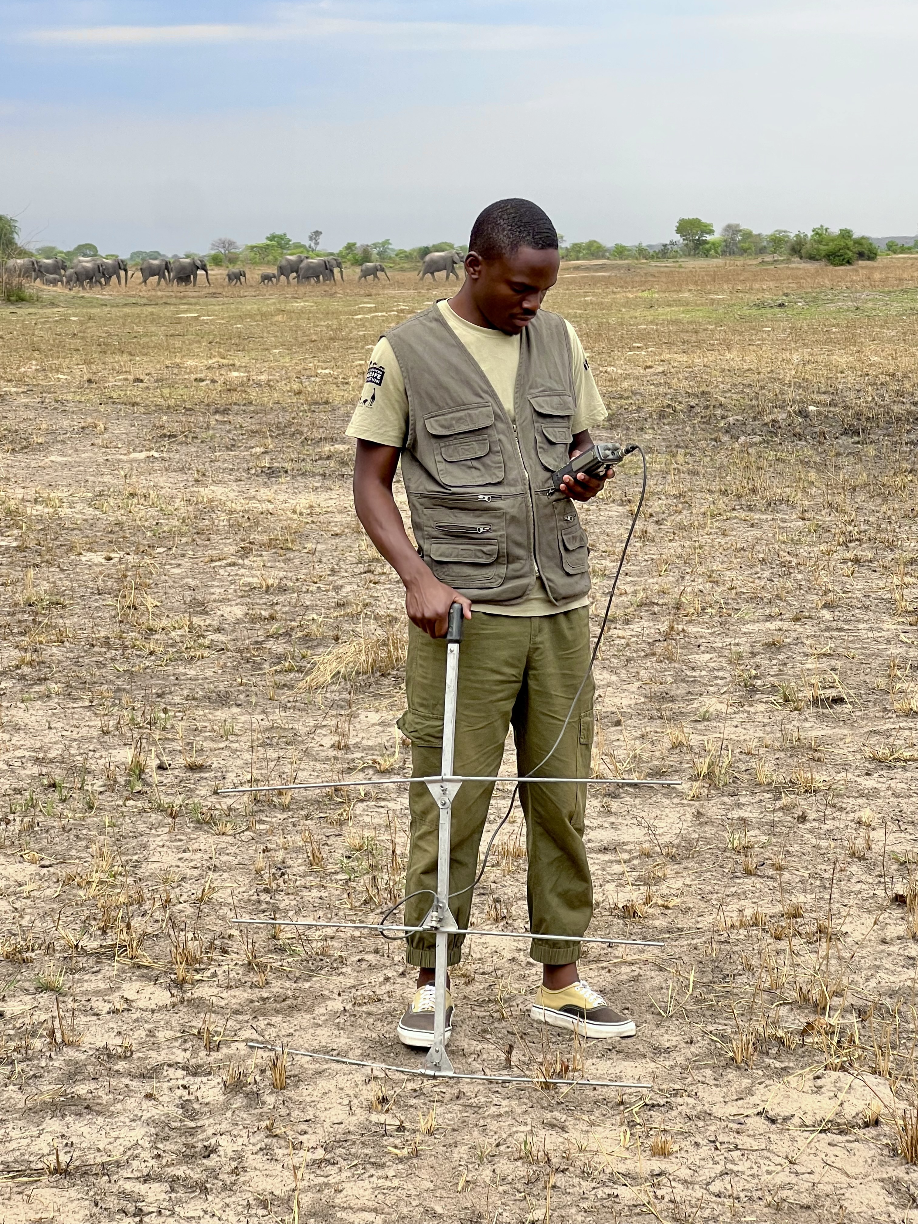
Kasi Amor Kalande
This leads to an exciting blog we did recently, it also includes a spatial map indicating elephant movement tracks of an orphaned elephant who self released himself into the wild (Kafue National Park). Cartography was...
28 January 2025
Careers
Geospatial Guru: Mapping a Better Future

Elsa Carla De Grandi
Remote, United Kingdom
27 January 2025
Link
Early Wildfire Smoke Detection Method Based on EDA

Ahmed Junaid
https://doi.org/10.3390/rs16244684
27 January 2025
https://doi.org/10.1098/rstb.2023.0327
26 January 2025
Link
Nature Climate Change (2025).
26 January 2025
Link

Updated version of the Spatial Database of Planted Trees (SDPT), which differentiates planted forests and tree crops from primary and secondary natural forests. Update has double the number of countries covered
25 January 2025
Link
New Data Provides First Global Annual Picture of Cultivated and Natural Grasslands

Elsa Carla De Grandi
The Land & Carbon Lab developed a new dataset that provides global maps of grassland extent annually from 2000 - 2022 at a 30 m resolution. These maps are critical for tracking changes in grassland ecosystems,...
25 January 2025
Article

Over the years, a large number of developments have gone up in the area that I live in and the municipality is not doing what they should when it comes to upholding the laws that have been put in place to protect the...
20 January 2025
Special Issue: Remote Sensing of Solar Radiation Absorbed by Land Surfaces
19 January 2025
Careers

The Department of Wildlife, Fish, and Environmental Studies (WFE), SLU, Umeå, is looking for a postdoc with strong interests in wildlife conservation technology.
15 January 2025
Link
Google Earth Engine Tutorial-100: Heatwave Mapping
Ahmed Junaid
Google Earth Engine with Amirhossein Ahrari
15 January 2025
June 2025
event

Joel Masselink
October 2025
event

Lacey Hughey and 3 more
November 2025

April 2023

event
Netty Cheruto
event

Stephanie O'Donnell
March 2023
event
Netty Cheruto
February 2023
event

Cassie Anderson
126 Products
Recently updated products
| Description | Activity | Replies | Groups | Updated |
|---|---|---|---|---|
| Hi everyone, I’m excited to become a member of Wild Lab! I’m currently working on my master’s thesis, focusing on dormouse conservation. My research explores the behavioral... |
|
AI for Conservation, Animal Movement, Camera Traps, Citizen Science, Community Base, Data management and processing tools, Early Career, Geospatial | 2 months 1 week ago | |
| Hello! I'm wondering whether there's anyone on here who would be able to offer me some guidance on storing spatial data in Microsoft Azure... |
|
Geospatial | 4 months 2 weeks ago | |
| Thank you! I will follow up by email. |
+8
|
Animal Movement, Conservation Dogs, East Africa Community, Geospatial, Sensors, Women in Conservation Tech Programme (WiCT) | 2 months 1 week ago | |
| Thanks @VAR1 great insights! Funny you mentioned the honey thing, @hikinghack said the same in response on the GOSH forum. I think the point I'm trying to make with the vegan... |
|
Open Source Solutions, AI for Conservation, Conservation Tech Training and Education, Ethics of Conservation Tech, Geospatial, Software Development | 2 months 2 weeks ago | |
| How much does it cost to incorporate machine learning into your conservation drone geospatial analysis? How does it speed up your workflow... |
|
Conservation Tech Training and Education, Drones, Geospatial, Open Source Solutions, Sensors, Software Development | 2 months 3 weeks ago | |
| Hi Dan, Not right now but I can envision many uses. A key problem in RS is data streams for validation and training of ML models, its really not yet a solved problem. Any... |
|
Emerging Tech, AI for Conservation, Animal Movement, Build Your Own Data Logger Community, Camera Traps, Connectivity, Conservation Tech Training and Education, Data management and processing tools, Geospatial, Sensors | 3 months ago | |
| And if you are new to GFW...this new glossary that was added recently is very helpful to understand some key terms.Check it out here! |
|
Geospatial | 3 months ago | |
| I agree Adventina. I am also interested in "How has the climate variability affected the trend of BAT species in the ecosystem? and respond on their increase and (or) extinction.... |
|
Climate Change, Community Base, Geospatial, Women in Conservation Tech Programme (WiCT) | 3 months 1 week ago | |
| Kasi, Thanks for sharing the excellent blog on elephant collaring. The map at the end was interesting. Did you do further... |
|
Geospatial | 3 months 3 weeks ago | |
| We're extending the survey deadline! Please don't forget to let us know if you would like to speak about your work at one of the future Geospatial community events. Many... |
|
Geospatial | 3 months 3 weeks ago | |
| @cmwainaina check this out |
|
Drones, Conservation Tech Training and Education, Geospatial | 4 months ago | |
| Thank you David, a phenomenal source! |
+10
|
Drones, Geospatial, Protected Area Management Tools | 4 months 2 weeks ago |