Group curators

Vance Russell

Ahmed Junaid
- @ahmedjunaid
- | He/His

Elsa Carla De Grandi
Fauna & Flora
Who We Are
Geospatial data and analysis is critical for conservation, from planning to implementation and measuring success. Every day, mapping and spatial analysis are aiding conservation decisions, protected areas designation, habitat management on reserves and monitoring of wildlife populations, to name but a few examples. The Geospatial group focuses on all aspects of this field, from field surveys to remote sensing and data development/analysis to GIS systems.
How to Get Started
Want to learn more about how remote sensing is used in conservation? Check out the first two episodes of this season of Tech Tutors, where our Tutors answer the questions How do I use open source remote sensing data to monitor fishing? and How do I access and visualise open source remote sensing data in Google Earth Engine? You can also check out our Virtual Meetup Archive for a range of panels that overlap with Geospatial topics, or take a look at our Earth Observation 101 lecture series from Dr. Cristian Rossi.
Our Purpose
The WILDLABS Geospatial Group is for conservation practitioners, geospatial analysts, and academics that want to:
- Share geospatial resources, best practices, data, and ideas;
- Network amongst geospatial and data practitioners;
- Create peer learning opportunities;
- Promote the use of free and open-source geospatial software; and
- Improve the use of GIS software and geospatial analyses in conservation management and research.
Group curators

Over 35 years of experience in biodiversity conservation worldwide, largely focused on forests, rewilding and conservation technology. I run my own business assisting nonprofits and agencies in the conservation community


- 5 Resources
- 62 Discussions
- 12 Groups
- @ahmedjunaid
- | He/His
Zoologist, Ecologist, Herpetologist, Conservation Biologist


- 63 Resources
- 7 Discussions
- 26 Groups

Fauna & Flora
Remote Sensing Scientist, Conservation Technology & Nature Markets @ Fauna & Flora - WILDLABS Geospatial Group Co-Lead

- 34 Resources
- 28 Discussions
- 8 Groups

Currently a data scientist in industry working on mechanistic models of risk, previously worked on modeling coral reefs. I am interested in the potential for emerging technologies and new ideas to help us solve environmental crises.
- 0 Resources
- 0 Discussions
- 14 Groups

- @Kasi
- | He/him
Game Rangers International
Kasi Amor Kalande is a young conservationist with experience in elephant movement research, GIS, and conservation technology.
- 1 Resources
- 0 Discussions
- 7 Groups

- @tehreemafzal
- | Tehreem
Zoologist, Researcher
- 0 Resources
- 0 Discussions
- 1 Groups

- 0 Resources
- 0 Discussions
- 6 Groups

- @claumemo
- | she/her
- 0 Resources
- 0 Discussions
- 7 Groups
- @Manahil_ijaz
- | she
I’m a nature enthusiast who loves exploring wildlife and ecosystems. Through my research in ecology, I channel this passion into protecting and preserving biodiversity.
- 0 Resources
- 0 Discussions
- 3 Groups

A Highly Motivated and Enthusiastic Scholer. I done M.phil in Zoology From PMAS Arid Agriculture University Rawalpindi. My research Work focused on Identifying the pathogens of honeybee in Pakistan and finding there control method through Green Synthesis Nanotechnology.
- 0 Resources
- 0 Discussions
- 1 Groups
- 0 Resources
- 0 Discussions
- 1 Groups

- @Sumbul
- | Herpetologist
- 0 Resources
- 0 Discussions
- 1 Groups
- @Phillip_Swart
- | He
I'm a conservationist working in the Vulture conservation space in South Africa with a huge passion for technology.
- 0 Resources
- 0 Discussions
- 18 Groups
- @Prabisha
- | she/her
Dedicated research scientist with over 8 years of experience in cartography, spatial analysis, and statistical modeling to tackle environmental, public health, and socio-economic challenges. Passionate about leveraging geospatial technology to drive impactful solutions.
- 0 Resources
- 0 Discussions
- 12 Groups
Ecodash.ai is an artificial intelligence platform for ecological modeling, design, and restoration.

- 0 Resources
- 4 Discussions
- 7 Groups
Article
Earth Blox dataset review: Meta Global Canopy Height (1m)

Cassie Anderson
Review by Professor Iain H Woodhouse
29 April 2024
Careers
Ecologist Postdoctoral Research Fellow

Alex Rood
The incumbent will develop models and metrics that can be used to shape conservation policy using multiple data sources including camera traps, movement data and citizen science concerning the diversity and...
23 April 2024
Careers
The Smithsonian National Zoo & Conservation Biology Institute is seeking a Program Manager to help coordinate multiple organizations in an effort to integrate movement data & camera trap data with global...
22 April 2024
Careers
Postdoc: Biologging & Camera Trap Data Integration

Lacey Hughey
The Smithsonian National Zoo & Conservation Biology Institute is seeking a Postdoctoral Research Fellow to help us integrate movement data & camera trap data with global conservation policy.
22 April 2024
Article
Starting a Conservation Technology Career with Vainess Laizer

Esther Githinji
Watch our interview with pioneering young Tanzanian vulture researcher Vainess Laizer! Her research investigating the breeding success of white-backed vultures in the western corridor of the Serengeti ecosystem using...
16 April 2024
Careers
Post Doctoral Research Assistant at ZSL
Alex Rood
ZSL is looking for an enthusiastic research scientist to join the multidisciplinary team and help deliver a project in Wales to better understand the ecology of tope sharks (Galeus galeus) in North Cardigan Bay and the...
9 April 2024
Link
ibm-nasa-geospatial (IBM NASA Geospatial)

Stephanie O'Donnell
NASA and IBM have teamed up to create an AI Foundation Model for Earth Observations, using large-scale satellite and remote sensing data, including the Harmonized Landsat and Sentinel-2 (HLS) data.
28 March 2024
Careers
WWF is looking for consultant(s) with expertise in spatial data mapping and analysis.
19 March 2024
Careers
The Smithsonian’s National Zoo and Conservation Biology Institute (SNZCBI) is seeking two postdoctoral fellows to engage more directly with identifying conservation metrics for vertebrate communities and populations.
14 March 2024
Careers

The Max Planck Institute of Animal Behavior at its sites in Constance and Radolfzell offers an international, interdisciplinary, and collaborative environment that opens up unique research opportunities. The goal of our...
13 March 2024
Careers
Texas A&M is seeking applicants for a fully funded Ph.D. assistantship to begin a long-term study on collared peccary (also known as javelina) ecology in southern Texas.
13 March 2024
Article

Emerging trends for Nature-Based Solutions project assessments
8 March 2024
June 2025
event

Joel Masselink
October 2025
event
Lacey Hughey and 3 more
November 2025

July 2024
event

Wildlife Drones
126 Products
Recently updated products
| Description | Activity | Replies | Groups | Updated |
|---|---|---|---|---|
| Hi there! Funnily enough, I have been attending ARSET Trainings for years - I think I've participated in about 80% of the ones they have offered over that time - they are awesome... |
|
Geospatial | 8 months 1 week ago | |
| Thank you so much for your advice.🙏 |
|
Geospatial | 8 months 1 week ago | |
| Hi @benweinstein !Surely a general detector might be very useful for detecting objects in aerial imagery! Maybe something similar to what MegaDetector does in camera trap images,... |
|
AI for Conservation, Open Source Solutions, Protected Area Management Tools, Drones, Geospatial | 8 months 1 week ago | |
| Very interesting topic |
|
Citizen Science, Community Base, Open Source Solutions, Geospatial | 9 months 2 weeks ago | |
| Wonderfully |
|
Geospatial | 9 months 2 weeks ago | |
| Thanks!I'm definitely looking at Smart and EarthRanger for overall management eventually, but for now I just want to track what we have better - especially as a base map to... |
|
Geospatial, Data management and processing tools | 9 months 4 weeks ago | |
| @cmwainaina please take a look |
|
Animal Movement, AI for Conservation, Camera Traps, Connectivity, Data management and processing tools, East Africa Community, Emerging Tech, Ethics of Conservation Tech, Human-Wildlife Conflict, Marine Conservation, Protected Area Management Tools, Geospatial, Sensors, Software Development | 10 months ago | |
| Thanks, Cathy! |
|
Geospatial | 10 months 2 weeks ago | |
| Tagging @Chelsea_Smith so she sees this :) |
|
Geospatial, Data management and processing tools, Protected Area Management Tools | 11 months ago | |
| Hi Vance,I just wanted to assign landcover types to each point data. But you mentioning temporal change of landcover, that will be best analysis to do.Thank you so much,Sarah. |
|
Geospatial | 11 months 1 week ago | |
| Unfortunately I may fail to deliver so I cannot take it up. Am off net at times for two weeks straight. But excited about everything GIS so I follow keenly. Thank you... |
|
Geospatial | 11 months 3 weeks ago | |
| Thank you Carly, I will definitely take a look. |
|
Acoustics, Animal Movement, Climate Change, Conservation Tech Training and Education, Data management and processing tools, Geospatial, Software Development | 1 year 2 months ago |


How 3D Technologies are Reshaping Forest Ecology and Conservation
6 October 2023 1:13pm
GEO BON Monitoring Biodiversity for Action

5 October 2023 3:10pm
GIS & Data Science Specialist
28 September 2023 1:32pm
GIS & Data Science Specialist, Connected Conservation Foundation

27 September 2023 1:28pm
GIS in Disaster Risk Management Training
26 September 2023 12:22pm
1st Wildlife Scientific Conference 2023
25 September 2023 11:10am
IUCN and AI2 to provide AI technology at no cost to fast-track implementation of newly signed UN High Seas Treaty

22 September 2023 9:54am
CIEEM 2023 Autumn Conference: Modernising Ecology: Techniques and Approaches
5 September 2023 1:59pm
Intro to Systematic Conservation Planning with Marxan
5 September 2023 1:18pm
Remote Sensing | Free Full-Text | Estimation of Forest LAI Using Discrete Airborne LiDAR: A Review
5 September 2023 11:57am
Textbook: Cloud-Based Remote Sensing with Google Earth Engine
5 September 2023 11:49am
Ecosystems Conservation: Action with CSOS/NGOS - EXPRO+

1 September 2023 5:57am
Senior Spatial Ecologist
24 August 2023 11:22pm
How to report on biodiversity impacts at scale for TNFD
24 August 2023 12:41pm
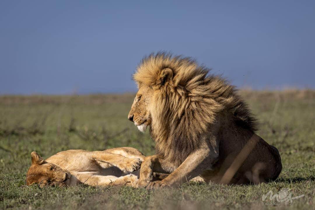
Born Free Uses Smart Maps to Save Lions, Solve Human-Wildlife Conflict
17 August 2023 2:35pm
Born Free Uses Smart Maps to Save Lions, Solve Human-Wildlife Conflict
Born Free maps the conflict between lions and communities to find solutions, including fortifying fences to keep lions away from livestock.

Conservation Technology Specialist

11 August 2023 1:21am
Society for Conservation GIS International Conference
26 July 2023 5:19pm
Deadline Approaching: GIS Capacity Internship

24 July 2023 5:18pm
Conservation StoryMap competition

17 July 2023 12:52pm
Monitoring large wildlife populations with ML and Satellites

11 July 2023 7:28pm
Deep learning enables satellite-based monitoring of large populations of terrestrial mammals across heterogeneous landscape | Nature Communications
New satellite remote sensing and machine learning techniques offer untapped possibilities to monitor global biodiversity with unprecedented speed and precision. These efficiencies promise to reveal novel ecological insights at spatial scales which are germane to the management of populations and entire ecosystems. Here, we present a robust transferable deep learning pipeline to automatically locate and count large herds of migratory ungulates (wildebeest and zebra) in the Serengeti-Mara ecosystem using fine-resolution (38-50 cm) satellite imagery. The results achieve accurate detection of nearly 500,000 individuals across thousands of square kilometers and multiple habitat types, with an overall F1-score of 84.75% (Precision: 87.85%, Recall: 81.86%). This research demonstrates the capability of satellite remote sensing and machine learning techniques to automatically and accurately count very large populations of terrestrial mammals across a highly heterogeneous landscape. We also discuss the potential for satellite-derived species detections to advance basic understanding of animal behavior and ecology. This study presents a deep learning pipeline to automatically locate and count large herds of migratory ungulates (wildebeest and zebra) in the Serengeti-Mara ecosystem using fine resolution satellite imagery. The results achieve accurate detection of nearly 500,000 individuals across thousands of square kilometers and multiple habitat types.

International Geoscience and Remote Sensing Symposium (IGARSS) 2023
4 July 2023 2:32pm
The role of low-code Earth observation tools in accelerating the sustainability transition
30 June 2023 2:13pm
The role of low-code Earth observation tools in accelerating the sustainability transition | Reports & Guides | Earth Blox
https://cdn.prod.website-files.com/60d1d38b8d988b72add3acc5/6819f4399e4c82c7333d3f0b_Reports%20-%20EO%20white%20paper.png

Due Diligence Technical Specialist - Climate Impact Partners
27 June 2023 11:31am
Plastics Remote Sensing Discovery Programme workshop
27 June 2023 10:08am
Information Session: Technology Testing to Mitigate Human-Elephant Conflict in West Bengal

19 June 2023 11:07pm
Innovation wanted: Technology Testing to Mitigate Human-Elephant Conflict in West Bengal
19 June 2023 10:54pm
The Wildlife Society Conference

19 June 2023 5:59am
GIS Application Specialist in Nairobi, DGB Group
15 June 2023 3:23pm