Free graphics for conservation tech communications
27 April 2025 4:39pm
28 April 2025 4:36am
Thanks for this! That's great! Also on a slightly different note - Unsplash is one of the better high quality stock image websites in terms of licenses, and most images are free to download. Although always be cautious of any species ID's, I have found that it's better to just take my own photos even if just on my phone.
Shutterstock vector graphics are not free but I have found it is great value for money, especially if you have Adobe illustrator or similar so can customise the graphics. They have a great range of graphics as well. You can do a month-to-month subscription for $53 AUD for 10 images / graphics per month.
Análise de Cluster no Kaleidoscope Pro: de Classificadores Simples a Avançados (Intermediário)

24 April 2025 7:03pm
Extração de Sinais Usando o Kaleidoscope Lite (Intermediário)
24 April 2025 7:01pm
Introducción al uso de Kaleidoscope Pro para Murciélagos (Principiante)
24 April 2025 6:54pm
Transformando el Sonido en Descubrimiento (Principiante)
24 April 2025 6:50pm
Reunión de la Comunidad Latinoamericana: Aplicaciones de Drones en el Monitoreo de Fauna
 Vanesa Reyes
and 1 more
Vanesa Reyes
and 1 more
24 April 2025 4:08pm
SpeciesNet: first impressions from 37k images in Namibia
23 April 2025 11:28pm
Neural Nets in Namibia, Kaggle in the Karoo | by Molly Blank | Medium
Earlier this year, the good people of Google released a new camera trap species classifier into the wild. With more than 2000 species classes, SpeciesNet is in a league of its own for the moment. The…

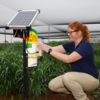
New Insect Camera Trap is Now Available!

23 April 2025 7:26pm
RFP: AI + freshwater biodiversity

23 April 2025 5:47pm
What software to use?
6 March 2025 4:39pm
19 April 2025 1:08pm
Apologies as I haven't tried this option: AddaxAI (Previously known as EcoAssist). It can work offline, however currently only works for species for which a specific project has already been developed.

22 April 2025 7:39am
Actually, detection of ~2000 "global" species is now supported in AddaxAI via supoort of SpeciesNet.
23 April 2025 3:28am
That's great!
Project Update — Nestling Growth App
22 April 2025 10:45pm
Geospatial Group Café April 22

21 April 2025 6:47pm
Beyond the Tech Hype / Más Allá del Hype Tecnológico

21 April 2025 3:59pm
Drone & ai use for uncovering illegal logging camps
21 April 2025 4:49am

21 April 2025 12:49pm
Hi Adam!
Sounds like you have your work cut out for you. I have not used radar systems or AI systems for this sort of detection, but there are methods using change detection models to visualise changes in forests where logging may be occuring between different dates using drone photogrammetry and GIS software. I have found these methods very effective when monitoring deforestation, especially because not only can you quickly visualise where deforestation has happened, but you can also quantify the damage at the same time. Let me know if you would like to learn more.
Kind regards
Sean Hill
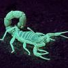
WILDLABS AWARDS 2024 - Enhancing Pollinator Conservation through Deep NeuralNetwork Development

7 April 2024 5:55pm

18 April 2025 10:33pm
Hi Kim,
That's really interesting! I didn't realize thermal worked with bees! Thanks so much for sharing that detail.
Liz

19 April 2025 12:40pm
Great work! Do you think the night time models also worked better due to lack of interference from shadows being counted? or maybe issues around a non-standard background.
If it helps, I believe the creators of InsectDetect which is open source, did a lot of work training their model to differentiate insect shadows vs. insects. Also after testing their smart trap on flowers, went with a standardised, non-lethal attractive background.
InsectDetect: Build your own insect-detecting camera trap!
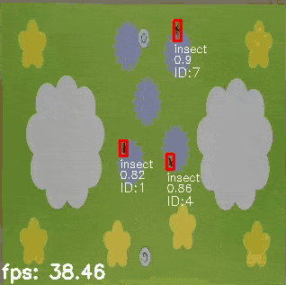
20 April 2025 5:14pm
Hey Amber, that makes a lot of sense! And this effort by Insect Detect is amazing, thanks for sharing!
MyProgress: Advancing GIS and R programming skills.
20 April 2025 1:45pm
Introducción al uso de Kaleidoscope Pro para Murciélagos (Principiante)
18 April 2025 3:50pm
Global Science Data Management and AI Graduate Intern

18 April 2025 2:52pm
Enterprise Geospatial Undergraduate Intern
18 April 2025 2:50pm
FROM VULNERABILITY TO SECURITY: INSPIRING COEXISTENCE THROUGH A RESILIENT BOMA

17 April 2025 8:41pm
WILDLABS-WWF Graduate Intern
 WILDLABS Team
and 1 more
WILDLABS Team
and 1 more
17 April 2025 6:06pm
Catch up with The Variety Hour: April 2025
16 April 2025 5:00pm
¡Bienvenidos a la comunidad Latinoamericana! // Welcome to the Latin American community!
30 September 2024 5:05pm
6 October 2024 4:11pm
Bem-vindo Rafael!!

16 April 2025 4:40pm
Hola. Me gusto la idea! prefiero en español, mas que nada en todo este tema de informatica, etc, que ya posee un alto grado de dificultad. Aca en Argentina estoy trabajando con anfibios y grabadoras digitales automaticas, ahora comenzando a explorar sobre detección automatica o semiautomatica.
16 April 2025 4:52pm
Bienvenido Maxi!
Ground Truth: How Are You Verifying What Maps Show?
 Léa Smadja
and 1 more
Léa Smadja
and 1 more
16 April 2025 3:35pm
Overview of terrestrial audio recorders with associated metadata info
15 April 2025 2:53pm
Frontiers | Key Issues for Realizing Open Ecoacoustic Monitoring in Australia
Many organisations are attempting to scale ecoacoustic monitoring for conservation but are hampered at the stages of data management and analysis. We reviewe...

Geospatial Group Café (April)
 Elsa Carla De Grandi
and 2 more
Elsa Carla De Grandi
and 2 more
15 April 2025 11:38am
21 April 2025 4:59pm

23 April 2025 9:17am
11 June 2025 11:05am
WILDLABS Climate Week Conservation Tech Meetup: Washington, DC
 Alex Rood
and 2 more
Alex Rood
and 2 more
14 April 2025 6:47pm
Conservation Applications for Google Solar API

12 April 2025 11:35am

14 April 2025 12:54pm
Do you know if there are plans to expand this beyond the global North? Many folks in this community are living and/or working outside of the areas where this dataset is limited to and thus would not be able to make use of it.
14 April 2025 6:27pm
Yes, I know about this big limitation,
As far as I know they are working to increase the coverage available for this solution.
For trusted developers, there are more regions available.
More information about the coverage can be found here:

DeepFaune v.1.3 is out!

14 April 2025 3:50pm
Papers about gender and disability in conservation tech

21 March 2025 4:56pm
11 April 2025 10:26pm
Wow, thanks for sharing @Nycticebus_scientia. Would love to read further papers on these topics if folks have them!
27 April 2025 9:03pm
Not directly conservation tech imagery, but we've used the open to contributions PhyloPic library and API on a few projects to get some cute and usable sillhouettes based on taxonomies.
PhyloPic
PhyloPic is an open database of free silhouette images of animals, plants, and other life forms, available for reuse under Creative Commons licenses. Download silhouettes for use in educational materials, research articles, and other projects.