Field testing the PolarBearWatchdog!

23 June 2025 12:24am
Bridging Worlds: Bringing Google Earth Engine to Desktop GIS Users!

21 June 2025 8:28am
Bridging Worlds: Bringing Google Earth Engine to Desktop GIS Users! | by Google Earth | Google Earth and Earth Engine | Jun, 2025 | Medium
Google Earth Engine is now more accessible with new ArcGIS Pro & QGIS connectors! Streamline your geospatial workflows with powerful cloud capabilities. 🌍✨

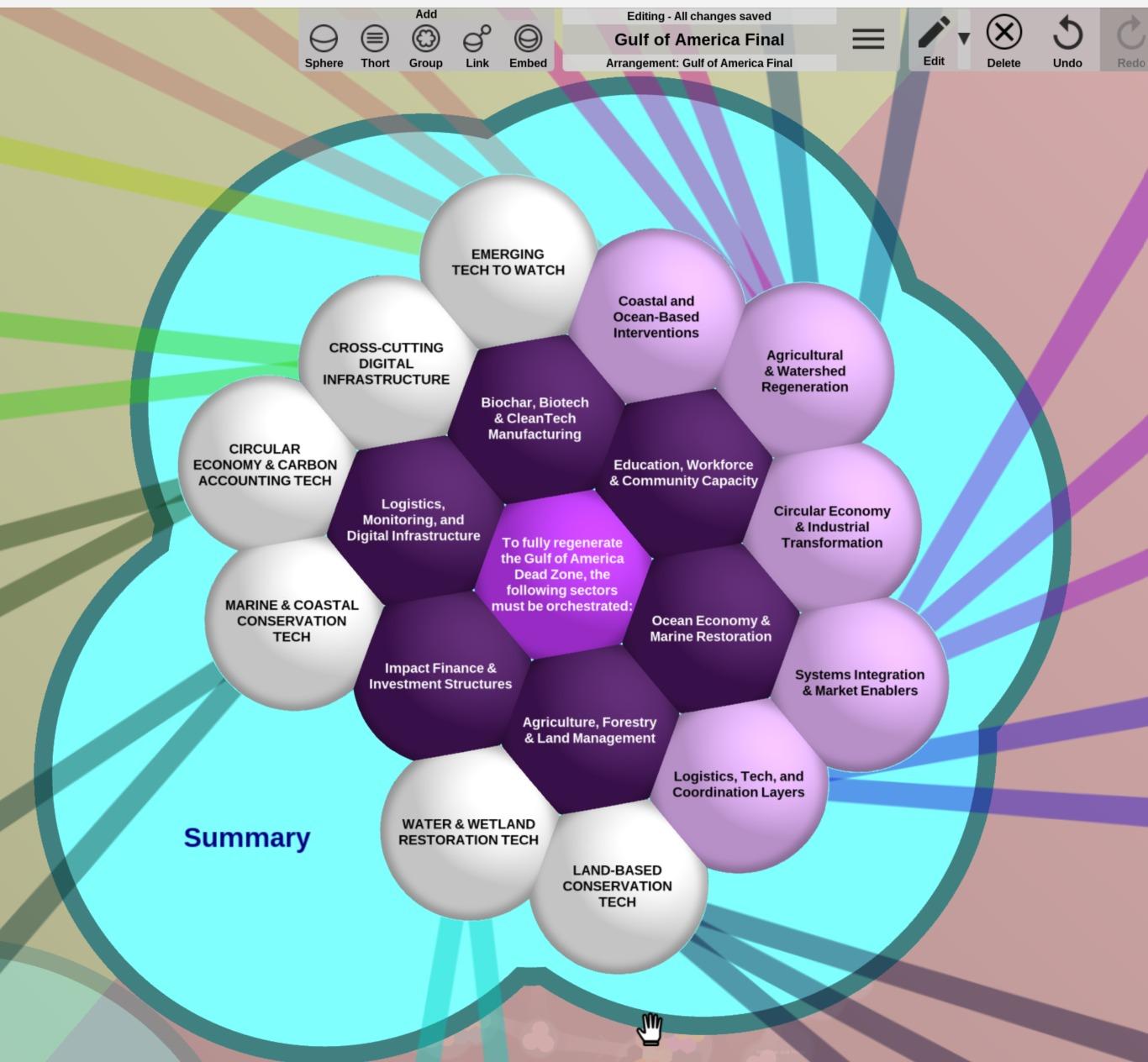
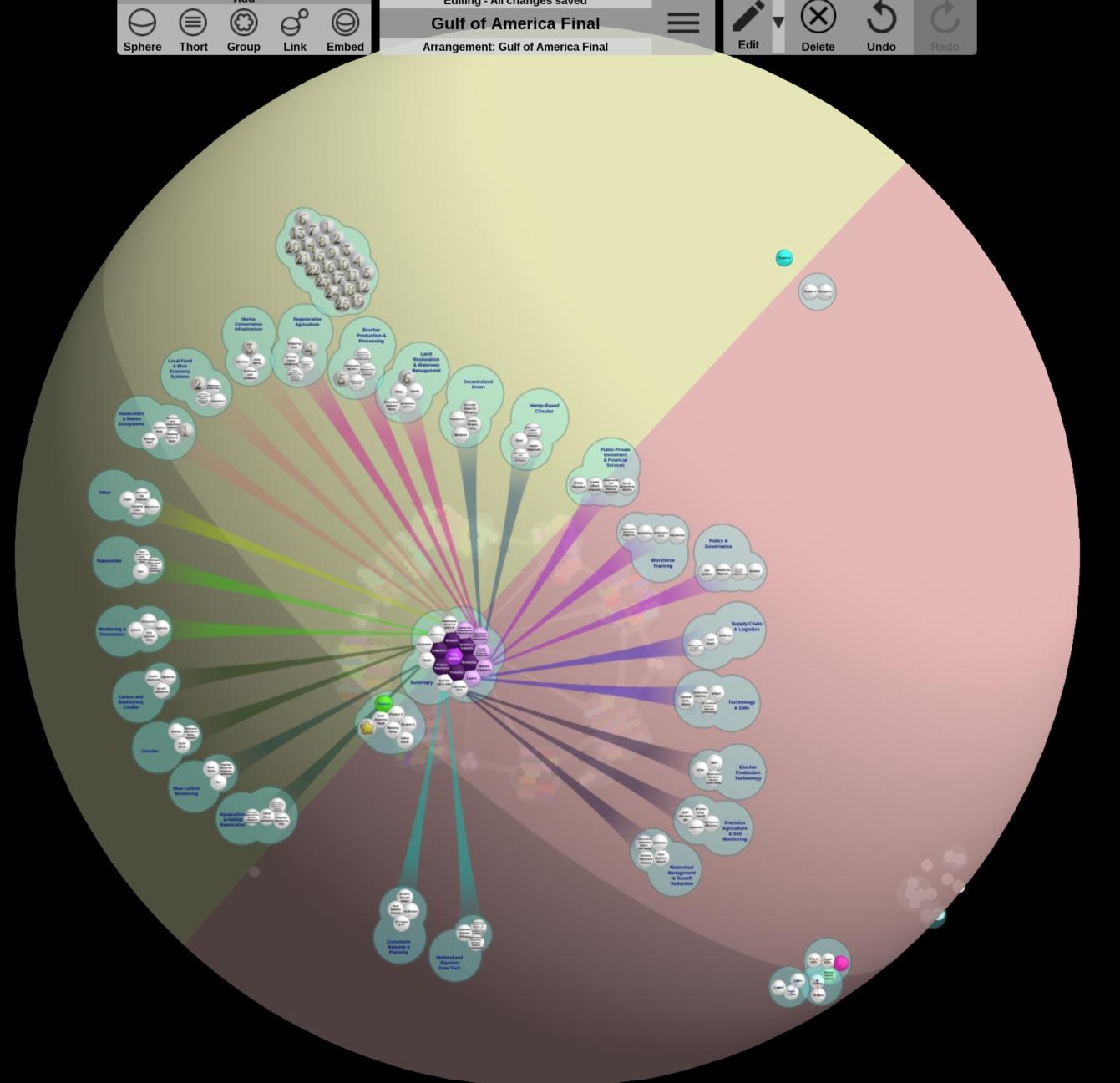
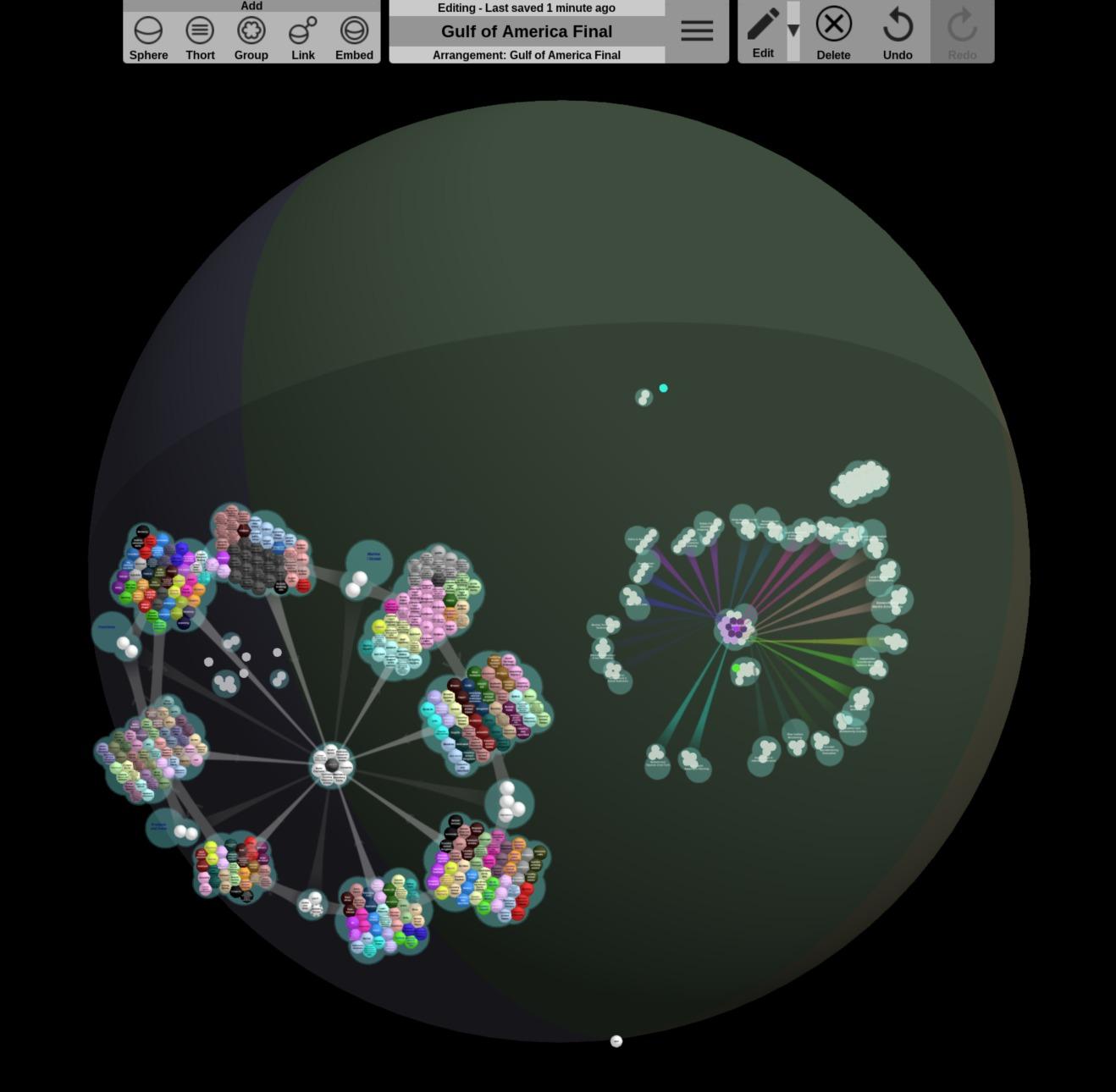
Gulf of America Dead Zone Restoration

9 June 2025 9:49pm
21 June 2025 6:22am
Hi WILDLABS Community! I have started mapping the project for the Gulf of America Dead Zone and here are some photos of the progress.
In the last picture, I have included WILDLABS entities at random and I will be mapping them to the industry collaborators we are seeking.
I hope to have any interested parties please reach out and if you'd like to contribute your technology, wisdom, or just follow along, I appreciate it! Thank you
WILDLABS AWARD 2025 - Automatization of a Contact-Free Saliva Sampler for Wildlife Conservation

28 May 2025 2:29pm

13 June 2025 8:41pm
Amazing! Thank you for sharing!

19 June 2025 6:28pm
I eagerly await further information about the progress of this type of technology and its availability. I am a wildlife veterinarian with experience in handling and capturing wild carnivores, and this type of device would certainly facilitate epidemiological monitoring of elusive and logistically difficult-to-handle wildlife species. Greetings from Chile!

20 June 2025 9:04pm
Hola, Alen! I'm a veterinarian too and this device is being developed thinking of you and your colleagues. We want field veterinarians to be able to collect more samples with less risks (for animals and people). Check us out at @swab_biosampler and linktree swab biosampler. Greetings from Brazil!
Practice guidance for protected and conserved area finance

19 June 2025 2:01pm
New Group Proposal: Systems Builders & PACIM Designers
18 June 2025 2:52pm
19 June 2025 9:08am
Hi Chad,
Thanks for the text. As I read it, PACIMs play a role in something else/bigger, but it doesn't explain what PACIMs are or what they look like. Now I've re-read your original post, I'm thinking, maybe I do understand, but then I feel the concept is too big ( an entire system can be part of a PACIM ? ) to get going within a WildLabs group. And you want to develop 10 PACIMS within a year through this group? Don't get me wrong, I am all for some systems change, but perhaps you're aiming too high.
19 June 2025 12:19pm
Hello again sir - PACIMs really mean 'projects' is the way I see it. Each part of the acronym can be seen as a project (if you have an assignment to do, you have a project really).
As for your query on 10 projects in 'this' group - I should ask for clarification if you mean particularly acoustics or in any group (I see now this is the acoustics thread after I selected all the groups for this post). If you are asking on acoustics, you're right - I am unsure on 10 as I am not too keen on acoustics yet. If you are asking 10 projects as a whole like 10 projects in the funding and finance group - I believe 10 to be a very reasonable number. Our projects we have co-created are for the most part replicable, rapidly deployable, quickly scalable, fundable through blended finance and more.
Thank you again for the feedback.
19 June 2025 1:43pm
Thank you for your reply, Chad
I meant 10 as a whole, indeed. Perhaps you see your post in one group, but since it is tagged for all groups, I assumed you meant 10 in total.
In your first post you explain PACIM stands for "Projects, Assignments, Campaigns, Initiatives, Movements, and Systems", so I understood it as more than just projects. Obviously, many things can be packed into a project or called a project, but then, what does it mean that 'Projects' is part of the list?
Well, if you think 10 projects is doable, then don't let me stop you.
Opportunity to participate in study on what counts as evidence in conservation

19 June 2025 11:11am
ICCB 2025 – Let’s Connect!

9 March 2025 5:06am

16 June 2025 8:33am
Hey Stephanie,
I have dropped you couple of links. I believe we also have a booth somewhere.
16 June 2025 8:41am
Hi Stephanie,
It’s great to hear about your exciting work and that you’ll be attending ICCB 2025 — congratulations on presenting!
The Savannah Tracking team is participating at the exhibition, and we’d love for you to stop by our booth 15.
Given your previous interest in collaring domestic dogs and collecting high-resolution GPS data, it might be a great opportunity for us to connect in person and dive deeper into how our lightweight collar solutions — like those currently deployed on Dingoes — could support your project. We'd be happy to show you how our satellite-enabled collars work, demo our data platforms, and explore a potential fit for your needs.
19 June 2025 7:34am
Thanks Fadhilla! I met with your colleague Henrick at the booth. :-)
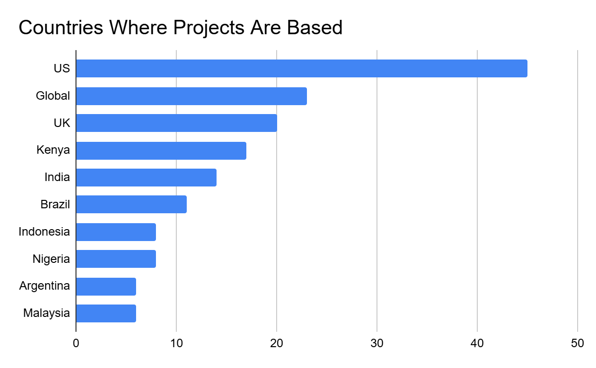
WILDLABS Awards 2025 Statistics

30 March 2025 9:53pm

18 June 2025 11:15am
While the United States remains the most represented individual country in terms of project locations, North America as a region ranks fourth overall in the total application pool. This suggests a broader geographic spread and greater participation from a wider range of countries.
Notably, only two African countries appear in the top 10 list below despite the fact that Africa is the region with the highest representation. This shows that projects based in Africa were distributed across many different countries rather than concentrated in just a few.
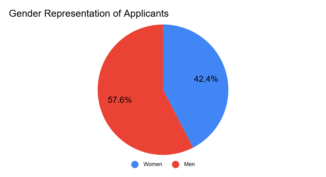
18 June 2025 11:17am
As shown below, of the 1,446 team members listed in applications 42.4%, identify as women. While this falls short of our target of at least 50% female representation, it marks a 12.4% increase from last year, an encouraging sign that we are moving in the right direction
This aligns with findings from our State of Conservation Tech reports, which highlight that women remain underrepresented in the sector. However, this year’s data suggests a positive shift may be underway.
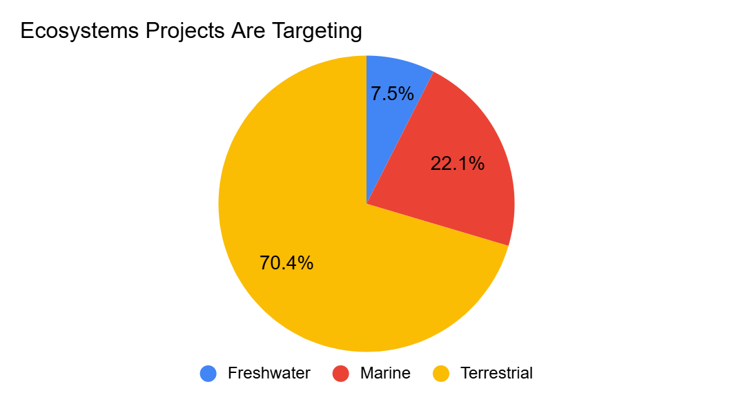
18 June 2025 11:17am
Due to several factors, such as accessibility, cost, and the ease of adapting technologies from other fields (e.g., drones developed for military use), available conservation technologies are currently better suited to terrestrial environments, giving terrestrial applicants a wider range of tools to choose from. In contrast, underwater environments present unique challenges, including the need for waterproof equipment and the difficulty of transmitting data through water.
As a result, marine and freshwater research and projects remain underrepresented in the conservation technology space. This is reflected in our current application pool, where terrestrial projects account for 70.4% of submissions. This imbalance highlights the urgent need for greater investment in marine and freshwater conservation technologies, which are equally important to the future of biodiversity protection.
Imageomics FuncaPalooza 2025

17 June 2025 6:21pm
Help the Funding and Finance group
17 June 2025 1:22pm
19 June 2025 5:05am
19 June 2025 8:47am
How drones, AI & Open Source Software are being used to combat Alien Invasive Plants in South Africa

2 June 2025 10:08am

7 June 2025 9:36pm
Hi Ginevra, thank you! Its such a huge advantage to have tech tools available to us in conservation. Not just from an analysis point of view but also from a practical application view😊
17 June 2025 1:26am
Aloha, this is a great project. Thanks for sharing. I have been looking for ideas to integrate machine learning with some of the conservation work we are engaed in here on Kauai. Thank you
17 June 2025 11:00am
Thank you for your comment Chris! Using these tools has made a huge difference in the way we can monitor and manage Invasive Alien Vegetation. I hope you are able to integrate similar systems with your projects there. If you need any help, feel free to reach out!
Nature FIRST Conference

16 June 2025 8:37pm
Catch up with The Variety Hour: June 2025
16 June 2025 3:21pm
WILDLABS AWARDS 2025 - Pioneering Acoustic Tags for Mysterious Hebridean Giants (Basking Sharks)

16 June 2025 1:12pm
Documentary on Conservation

5 May 2025 10:12am

20 May 2025 11:16pm
Hi Nick,
At Wildlife.ai, from the other side of the world, we would be happy to chat with you. PM if interested
Victor
2 June 2025 10:19pm
Hi Nick!
At Birds Canada, our NatureCounts open data platform connects bird and biodiversity data with people who need it for conservation and research. In particular, our mobile app makes data collection by citizen scence and research projects more efficient, accurate, and accessible. We are happy to chat, if that aligns with your project!
Kyle

16 June 2025 8:53am
Hi Nick,
Thank you for reaching out and for the incredible work you’re doing to spotlight conservation through film. We’d be very interested in learning more about your documentary project.
At Savannah Tracking-Home - Savannah Tracking, we design and manufacture innovative wildlife tracking technologies — from lightweight GPS tags/collars for birds and medium-sized mammals, to robust satellite-enabled collars for elephants (Asian & African). Our tools are used worldwide to support wildlife conservation, research, and conflict mitigation by providing real-time movement data.
We’d be happy to connect and explore how our work might fit into the story you're telling around technology's role in conservation. Feel free to reach out to us or let us know the best way to continue the conversation.
Looking forward to hearing from you
New Global Efforts to Map and Monitor Kelp Forests Extend to South Africa and Namibia
15 June 2025 11:01am
New Global Efforts to Map and Monitor Kelp Forests Extended
A new expansion of Kelpwatch.org brings more than 40 years of satellite-derived kelp canopy data to South Africa and Namibia.

Planet Imagery is no longer available on GFW
15 May 2025 2:15pm

10 June 2025 6:22pm
Same! We're just having to use the available VHR Airbus and Maxar imagery on Google Earth Pro for visual assessments but that's not quite the same (given the restrictions and availability) and does not fit with all our needs for sure. If for your area of interest the Google Earth Pro imagery is very old it looks like you can request an update (although this link is quite old and haven't tried it myself). Obviously this is not really an alternative but can help with some use cases.
13 June 2025 1:27pm
FYI: Global Mangrove Watch still makes the monthly Planet NICFI imagery available via their platform (link).
15 June 2025 10:45am
that's really useful! thanks for flagging that :)
Remote Sensing of Tropical Dry Forests in the Americas
15 June 2025 10:38am
Remote Sensing of Tropical Dry Forests in the Americas: Ecology, Conse
This second edition focuses on Tropical Dry Forests (TDF) in the Americas and provides a comprehensive overview of new studies conducted in the last decade, giv

Acoustic monitoring for tropical ecology and conservation
15 June 2025 10:33am
Smart Drone to Tag Whales Project

8 June 2025 12:19pm

14 June 2025 12:19pm
I would love to hear updates on this if you have a mailing list or list of intersted parties!
Is Crablante the New Korg?

15 June 2025 10:43am
Prototype for exploring camera trap data

20 January 2025 10:23pm

7 May 2025 10:49am
@Jeremy_ For the Python implementation of basic occupancy models (as suggested by @ollie_wearn ), please refer to these two projects:
I second @martijnB suggestion to use spatially explicit occupancy models (as implemented in R, e.g., https://doserlab.com/files/spoccupancy-web/). However, this would need to be added to both of the aforementioned Python projects.
17 May 2025 10:53am
Lively and informative discussion, I would very much like to contribute if there is some active development work with regards to this.
I have recent experience with using Model Context Protocol (MCP) to integrate various tools & data repositories with LLMs like Claude. I believe this could be a good idea/path whereby we can do the following:
1. use the images & labels along with any meta-data, chunk/index/store it in vector db
2. integrate with existing data sources available by exposing the data through MCP server
3. Use MCP friendly LLM clients (like Claude) to query, visualize and do other open-ended things leveraging the power of LLM and camera trap data from various sources.
Regards,
Ajay

13 June 2025 1:38pm
Hi Jeremy,
I am copying here a reply from Juliane Röder, who is not on the forum here:
The GFBio VAT tool seems to do all the desired analysing and visualising stuff - but it isn't specialized on camera trap data. Instead, it harvests GBIF, GFBio data centers, and environmental data that you can combine in any way you want: https://vat.gfbio.org/#/
Documentation with some example code and notebooks is here: https://docs.vat.gfbio.org
A standalone tool for camarea trap data and images is nice, but maybe joining forces and adding some functionality to the VAT tool to better handle camera trap data would be a more sustainable solution...?
The VAT tool can give you some simple statistics of the chosen data (e.g. occurences of wild cats in central Europe in winters 2000-2015), and some simple analyses (wild cat occurences and snow depth). It's focus is on geospatial analyses of occurrence data. They do not have any functionality specific for camera trap data - yet.
My point was, that if you want geospatial analyses and/or additional data to compare to camera trap data, you probably don't have to build a new tool.
I'm not involved with the development of the VAT tool, but I could help with the contact. I know the VAT team.
You can contact her on juliane.roeder@uni-marburg.de.
I did a quick exploration of the VAT tool. It is built quite differently, and my first impression is that it is less accessible; however, as you become more familiar with it, you discover a wide range of options to explore for DwcA occurrences.
I believe it is extremely valuable to also have a tool that works directly with the richest data (Camtrap DP), rather than relying on translated data (Darwin Core), where important details and data structure are lost.
I also think the goals of both tools are different: map-based analysis vs. exploration.
But still usefull to get to know about each other :-)
Drone Imagery and Deep Learning enabling northern gannet counts
12 June 2025 9:52pm
Bass Rock Colony Counts - Scottish Seabird Centre
The Scottish Seabird Centre work in close collaboration with The University of Edinburgh School of Geosciences, The University of Edinburgh Airborne Research and Innovation Facility, UK Centre for Ecology & Hydrology, and Edinburgh Napier Centre for Conservation and Restoration Science to conduct count surveys of Northern Gannets breeding on Bass Rock.

Oportunidades laborales en investigación en la Amazonía | UTEC - ASRI

12 June 2025 4:56pm
How AI can protect mangroves

12 June 2025 4:16pm
Feedback needed for new Tech Concepts

3 June 2025 12:43pm
11 June 2025 10:44pm
Gina- Sounds like an interesting thesis topic! I work with bioacoustics in offshore waters and I'd be happy to have a chat and provide feedback-- feel free to message me via Wildlabs.
New Group Proposal: Bioinformatics for Conservation – Interested in Joining?
6 June 2025 7:28pm
11 June 2025 5:48pm
Thank you for creating this post to gauge interest, Nabil! It sounds like this fits under the already existing eDNA & Genomics group. Curious to hear your thoughts!
The future of finance: How EO is driving climate innovation in fintech education

11 June 2025 7:11am
The Locally-led East Asian Flyway Acoustics (LEAFA) Migratory Program; Harnessing emerging technologies to understand the impacts of a changing planet on ecosystem function of migratory birds in the East-Asian Australasian Flyway

11 June 2025 5:40am
23 June 2025 1:23pm
Looking forward to capturing the first polar bear. On film of course.