Group curators

Talia Speaker
- @TaliaSpeaker
- | She/her
WILDLABS
World Wide Fund for Nature/ World Wildlife Fund (WWF)

Lacey Hughey
- @lhughey
- | she/her
Smithsonian Conservation Biology Institute
Animal movement technologies have already significantly advanced our understanding of the natural world, from uncovering previously mysterious migration patterns and key movement corridors to demonstrating the impacts of anthropogenic pressures and climate change. Continuing advances in the development of technologies for collecting and transmitting bio-logging data, combined with the increased availability of high-resolution environmental data and analytical developments in movement modelling, are opening doors to novel applications. However, there are still major gaps in the space, including mobilizing movement data to translate data from tracking devices into insights for application in policy and practice. This group is a place for the animal movement community to connect and discuss our efforts to advance the field.
Resources for beginners
Learn about WILDLABS Animal Movement research projects
- MoveBON Initiative Announcement
- MoveBON Follow-Up Discussion
- Virtual Meetup Season 4: Tracking Progress (A WILDLABS research project on movement ecology)
Group curators
- @TaliaSpeaker
- | She/her
WILDLABS & World Wide Fund for Nature/ World Wildlife Fund (WWF)
I'm the WILDLABS Research Specialist at WWF-US


- 23 Resources
- 62 Discussions
- 25 Groups
- @lhughey
- | she/her
Smithsonian Conservation Biology Institute
I am an ecologist and program manager with experience leading collaborative research projects in international settings. I specialize in the application of animal tracking data to conserve migratory species on a changing planet.


- 6 Resources
- 10 Discussions
- 3 Groups

PhD student at the University of Wuerzburg, working on the influence of climate change on animal migration, especially the Northern Bald Ibis.
- 1 Resources
- 0 Discussions
- 6 Groups

- @StephODonnell
- | She / Her


- 193 Resources
- 676 Discussions
- 32 Groups
- @Bibou
- | Her
Student at Bordeaux Sciences Agro
- 0 Resources
- 1 Discussions
- 2 Groups

- @Rob_Appleby
- | He/him
Wild Spy
Whilst I love everything about WILDLABS and the conservation tech community I am mostly here for the badges!!


- 1 Resources
- 315 Discussions
- 11 Groups
Hello, I am a PhD student studying birds and box turtles!
- 0 Resources
- 0 Discussions
- 9 Groups

Deeply intrigued by AI, I navigate its limitless potential with a commitment to making a positive impact.
- 0 Resources
- 0 Discussions
- 1 Groups

- @daviana
- | she/her
PhD student at Stanford University studying marine migratory species and human-wildlife interactions through biologging, remote sensing, and participatory science.
- 0 Resources
- 0 Discussions
- 3 Groups
- @lhughey
- | she/her
Smithsonian Conservation Biology Institute
I am an ecologist and program manager with experience leading collaborative research projects in international settings. I specialize in the application of animal tracking data to conserve migratory species on a changing planet.
- 6 Resources
- 10 Discussions
- 3 Groups

- @eliminatha
- | she
Passionate wildlife researcher dedicated to uncovering the secrets of the natural world via the lens of camera traps. With a sharp eye for detail and a strong commitment to wildlife conservation.
- 3 Resources
- 0 Discussions
- 5 Groups

Aarhus University
Biologist and Research Technician working with ecosystem monitoring and research at Zackenberg Research Station in Greenland


- 19 Resources
- 270 Discussions
- 7 Groups
PhD student
- 0 Resources
- 0 Discussions
- 5 Groups

Conservationist with a focus restoration ecology/rewilding and botany, a keen birder and currently working in the Seychelles
- 0 Resources
- 1 Discussions
- 5 Groups
Article
What makes a good detection dog handler? Is it something that can be taught and learnt over time, or is it something more intuitive? Do some people just have what it takes, and other people don’t? At the start of 2017...
3 November 2017
Article
In this From the Field interview, we speak to Dr. Raman Sukumar, a world renowned expert on Asian elephant conservation. He shares his thoughts on how technology could be used for mitigating elephant-human conflict, and...
5 April 2017
Article
Satellite tracking is the state of the art of technology for mapping wildlife movement. But what if your budget is not state of the art? In our second From the Field interview, we're talking with WILDLABS member and GIS...
29 March 2017
Article
#Tech4Wildlife Photo Challenge: Our favourites from 2016

WILDLABS Admin
Are you ready for this year's #Tech4Wildlife Photo Challenge? In anticipation, we're counting down our ten favourite entries from last year. Do you think you can top these?
1 March 2017
Funding
Conservation Leadership Programme 2017 Award
WILDLABS Admin
The Conservation Leadership Programme (CLP) is a training and capacity building programme that targets individuals from developing countries who are early in their conservation career and demonstrate leadership...
21 November 2016
Funding
Neotropical Migratory Bird Conservation Act grants via USFWS
WILDLABS Admin
Do you work on conserving Neotropical migratory birds? Do you need funding? Why not apply for a grant from the U.S. Fish and Wildlife Service through the Neotropical Migratory Bird Conservation Act's grant program? The...
8 November 2016
Article

Caves don't tend to be well-liked ecosystems, being extremely dark, often quite cramped, and slippery. And the creepy-crawlies that live within them can be the stuff of nightmares. Nevertheless, one's attitude towards...
25 July 2016
Funding
Wildlife Tracking Equipment Grants from Holohil Transmitters
WILDLABS Admin
Holohil Systems is now accepting applications for grants to support the purchase of wildlife tracking equipment of up to CDN $2,000 from the Holohil's own product line. Applications are welcome from any geographical...
20 July 2016
Article

Current efforts to track endangered Green Sea Turtles rely on tags that cost upward of $2000 per unit. Alasdair Davies of the Zoological Society of London has been working with Luka Mustafa, a Shuttleworth Foundation...
27 May 2016
Article
Text Messages from Teenage Gannets

WILDLABS Team
How do new colonies come about? And why do we observe young colonies to grow much more rapidly than their own production of chicks would allow them to? As Jana W. E. Jeglinski explains, cutting edge developments of...
25 April 2016
Article
When Victoria Espinel, President and CEO of BSA | The Software Alliance, spoke at the WWF Fuller Symposium, she took us on a whistle-stop tour of case studies where software and data are transforming our understanding...
10 March 2016
Article
Comparing Geolocator and High-Precision GPS Data
WILDLABS Team
Few recent technologies have been embraced by the ornithological community as rapidly as solar geolocation tracking devices. Although the first and rather large ‘geolocators’ became available more than two decades ago,...
9 March 2016
July 2025
August 2025
October 2025
event

Lacey Hughey and 3 more
November 2025

January 2025
event

Wildlife Drones
October 2024
event

Talia Speaker

91 Products
Recently updated products
| Description | Activity | Replies | Groups | Updated |
|---|---|---|---|---|
| Hi Emily,RFID tags and an array of readers is certainly possible. We developed a system for tracking translocated species using long range radio (LoRa) and internet of things (IoT... |
|
Animal Movement | 10 months 1 week ago | |
| Glad to announce that a new tutorial is available on Firetail: |
|
AI for Conservation, Animal Movement | 10 months 2 weeks ago | |
| A community device isn’t just about the technology; it’s also about creating a collaborative community. Shout out to all innovators... |
|
Animal Movement, Marine Conservation, Open Source Solutions, Sensors | 10 months 3 weeks ago | |
| Sorry @Paloma - somehow this reply escaped me. There are different transmission solutions depending on what you are trying to transmit, how much, how often, from where... |
|
Animal Movement | 10 months 4 weeks ago | |
| Fantastic!! |
|
Acoustics, AI for Conservation, Animal Movement, Build Your Own Data Logger Community, Community Base, Early Career, Ethics of Conservation Tech, Marine Conservation, Open Source Solutions | 11 months 2 weeks ago | |
| We'll be presenting Wednesday morning as part of session 10.1b on "Integrating earth observations and biological tools in ecology and evolution to cogenerate knowledge towards... |
|
Community Base, Animal Movement | 1 year ago | |
| We are ready to make efforts on materials, but today there are few solutions available. Today, our partners' R&D efforts are focused on renewable energies and the energy... |
+4
|
Animal Movement, Marine Conservation | 1 year ago | |
| Hi Jesse,For a material to be acoustically transparent (in air), the speed of sound in the material times its density must match that of air. Realistically, any solid... |
+1
|
Acoustics, Animal Movement | 1 year ago | |
| Congratulations! My first hydromoth was just arrived yesterday and so excited! Looking forward for the update from your project!!! |
|
Acoustics, Animal Movement, Climate Change, Conservation Tech Training and Education, Data management and processing tools, Emerging Tech, Open Source Solutions, Protected Area Management Tools, Sensors, Software Development, Latin America Community | 1 year ago | |
| I am working on that too haha. So in my design you load the glue gun with two part Loctite, it has two separate metal rings. Glue and hardener in each ring. Then each ring has a... |
+23
|
Animal Movement | 1 year 1 month ago | |
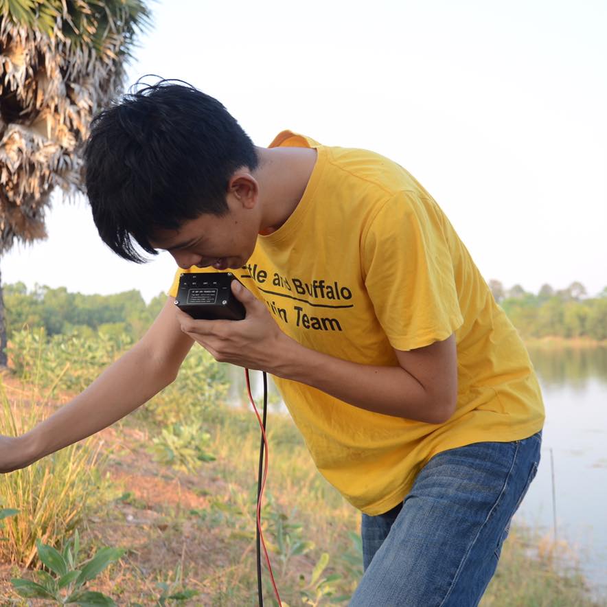
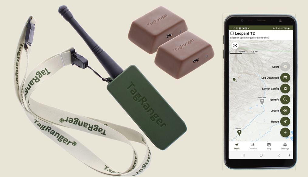
| Hi everyone, @craig joined last month's Variety Hour to chat about Tagranger, which you can read more about here. A TagRanger®... |
|
Animal Movement, Connectivity, Sensors | 1 year 1 month ago | |
| 'Most importantly, we have to make it play a MIDI version of the DoctorWho theme song when you arm the device. That has to be the #1 feature if you ask me!' Seconded! |
+9
|
Acoustics, Animal Movement, Emerging Tech, Open Source Solutions, Sensors | 1 year 1 month ago |


My VHF Telemetry Tag Building Project From Scratch
15 September 2024 2:32pm

28 November 2024 7:20am
@jcturn3 I’ve added the details for creating the tags, and I hope it will be helpful to you.

30 November 2024 11:05pm
Wonderful thank you! I'll look into it shortly.
Recovery Ecology Post Doctoral Associate - San Diego Zoo Wildlife Alliance
26 November 2024 11:47pm
Two Postdoctoral Fellowships on the Spatial Ecology of Bustard Species

11 November 2024 2:45pm
LoRa GPS monitoring
4 November 2024 2:54pm

6 November 2024 11:54am
Hi @ONCA
LoRaWAN can be used very successfully in the applications you have mentioned!
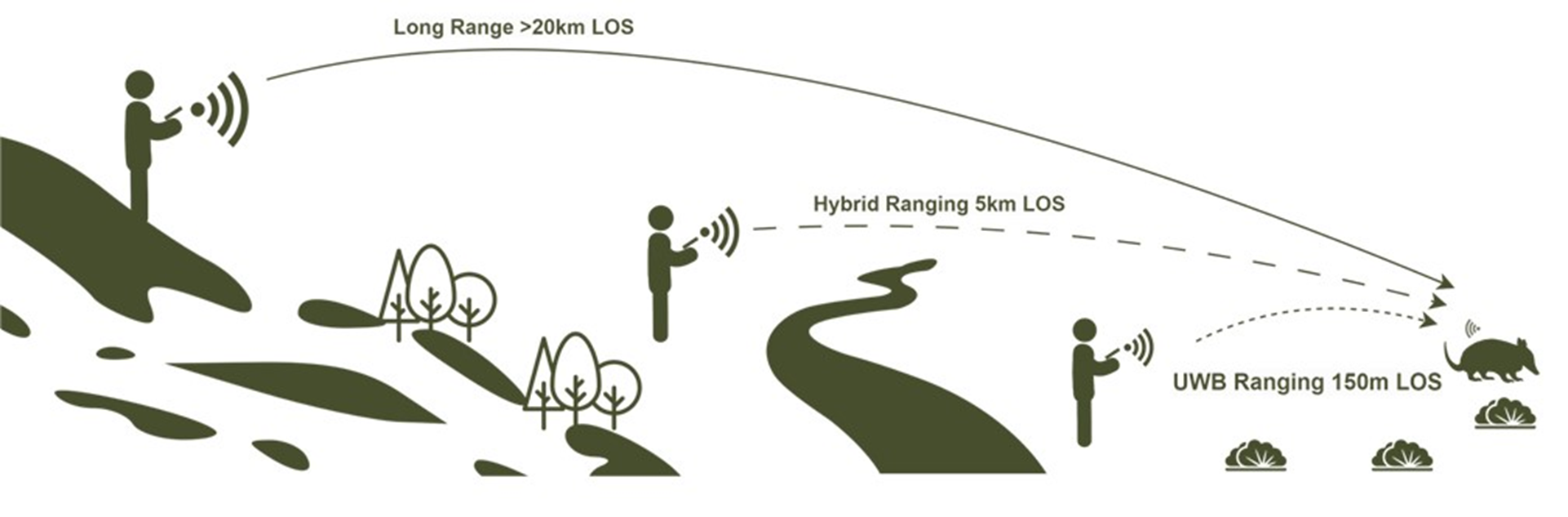
Our TagRanger system is based around LoRaWAN and we've done a lot of range testing in various environments to assess performance.
LoRaWAN has various 'spreading factors' which govern not only potential range, but also how often you can transmit. The lowest (SF7) has the shortest range but you can transmit very often, while the highest (SF12) has the longest range but you are more limited in how often you can transmit.
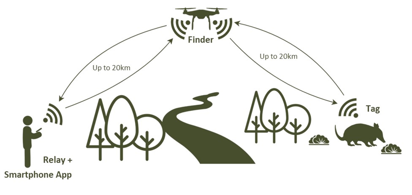
TagRanger can use a fixed LoRaWAN network installation, but we also have a 'Finder' device which acts as a LoRaWAN Gateway and attaches to your phone providing your own mobile LoRaWAN gateway you can pop up anywhere. This gives great mobilty and we've also added special features such as remote Tag wake-up which you don't get with LoRaWAN networks.
We've tested range using a Finder communicating with our standard Tag which has an integrated antenna in a number of scenarios. We had robust communications at 21km with a line of sight connection at which point we ran out of space! We could see from the LoRaWAN transmit/receive metrics that there was still plenty of headroom left to go even further, estimating >30km. As an aside, we've also had a turtle tracking version of our TagRanger Tag using an external wire antenna communicating at 48km.
We've also tested in a dense pine forest, in the rain (which makes things worse). We made sure the line of sight was through all the trees and could reliably connect over 1km away (before running out of room again) and this was approaching the limit.
Understanding that there are limits to LoRaWAN range, we also provide a 'Relay' capability with our TagRanger system. This allows you to effectively double the range between you and your Tag by putting the Finder on a drone, mast, balloon or strategic mountain top and hopping the connection from the Relay, to the Finder and on to the Tag.
The biggest advantage of using the Relay though, is that you can look down through a canopy (or into a valley) and mitigate issues with signal propagation through a load of trees.
Hope that helps for now, let me know if you would like any further information!
https://www.tagranger.com
Craig

11 November 2024 7:19am
I agree. With clear line of sight you can get really good coverage (High antenna on a hill or building and sensors/antenna within line of sight).
I have worked in Bolivia and the topography, vegetation cover and moving species in your area are very hard to work with. Also I can second @craig with humid forest in the rain reaching it´s max distance at about 1000m. Moving anmials make it much harder. I´m still a big fan of LoRa also beeing amazed by the fast pace of Meshtastic in recent weeks. Im really hoping for more LoRa over satellite solutions. This will hopefully solve lots of these issues.
Greetings from the Austrian (Rain) forest,
Robin

11 November 2024 8:25am
Hi @ONCA ,
Good to know you are looking into this. I have checked our email, but can not find any request for information or contact. Please reach out to me personally at tim@smartparks.org
15km range with any terrestrial wireless connectivity in the forest is not realistic, this has nothing to do with LoRa/LoRaWAN specifics, but with radio in general. The signals will be absorbed by the vegetation. Therefore you need to looks at different strategies then tracking wildlife in the savanna or desert. Bear in mind that also the GNSS (GPS) signals coming from the satellites will have the same issue.
Possible strategies:
- Using Mesh/Relay networks in increase network density
- Using "contact tracing"
- Using LoRaWAN to satellite
- Using downloading of "logs" at fixed locations in the forest
Happy to discuss further.
Building a flexible and detachable Yagi antenna
2 November 2024 9:16am
Can wireless charging technology be used for animal sensors?
17 October 2024 7:03am
23 October 2024 3:43pm
The results in the paper you mentioned are really exciting technology. It can really do a lot of things.
Thanks for your reply!
23 October 2024 4:00pm
Although this technology may not be mature now, and there are still many problems to be discussed and solved, I think it will have good application prospects.
Unfortunately, I am just an undergraduate student in China, and what I can do is very limited. Maybe in the future I can also do some similar research or what I want to do. Just like you, I am studying hard now.
Thank you very much for this forum and the professionals who responded to me. You have allowed me to see more perspectives and many things I didn't realize. Thank you very much!
28 October 2024 3:13pm
No problem at all Yu (@JY) and good luck with your studies! Happy to discuss this and any other ideas any time.
All the best,
Rob
COP16 Event: Harnessing Animal Movement Data to Meet Biodiversity Goals
21 October 2024 6:14pm
Roe deer protection needed in Hungary, national government should stop funding hunting organizations - call for international support

7 October 2024 11:58am

14 October 2024 12:41pm
Really? Can you share where its written.
Annex III: protected fauna species, do you need a glass?

14 October 2024 1:33pm
A quick search comes up with the following answer. Let us know if that helps.
Annex III of the European Environmental Agency (EEA) does not directly regulate the protection or hunting of specific species. Instead, it's important to look at Annexes II and IVof the EU Habitats Directive (Directive 92/43/EEC) for species protection and hunting regulations in the European Union.
Roe deer (Capreolus capreolus) is not listed in Annex IV (which covers strictly protected species), meaning it is not afforded the strictest protection that prevents all forms of exploitation. However, Annex III of the Bern Convention, which relates to species that may be exploited but require careful regulation, includes species like roe deer.
In many European countries, roe deer hunting is permitted under specific regulated conditions. These regulations aim to ensure sustainable hunting practices and maintain healthy population levels, with hunting seasons and quotas determined based on local wildlife management policies.
In summary, roe deer are generally not strictly protected across the EU, and hunting is allowed under regulation, though specific conditions depend on national and regional legislation.
Disclaimer: I can't guarantee that the above is not a hallucination :-)
15 October 2024 11:24am
Thanks, we know they are breeding these animals here, I asked, since it's seems to be an expensive hobby, we need to allocate more funding for rural women in entrepreneurship and access to technologies, reduce poverty in Hungary No1 priority.
That's the problem local peoples can not afford buying wild meat from the "local shop"
Fully uncontrolled activites in Hungary
MS and PhD Opportunities in Ocean Engineering and Oceanography

6 October 2024 9:44am
Calling for applications for Round 3 of our Satellites for Biodiversity Award Grant
30 September 2024 5:22pm
EarthRanger and Skylight for improving protected and conserved area effectiveness

23 September 2024 1:30pm
Tools for animating 3D flight paths from GPS and altitude data

1 August 2024 12:42am

5 September 2024 8:51pm
I will check it out, thanks for your help!
6 September 2024 7:24am
Hi Maggie!
I have used Google Earth Pro for quick and dirty animation of movements of muskoxen.
I prepared .gpx file with the online and free service https://www.gpsvisualizer.com/
GPS Visualizer
GPS Visualizer is a free utility that creates customizable maps and profiles from GPS data (tracklogs & waypoints), addresses, or coordinates.

based on .csv files of the track logs and simply "dumped" these in Google Earth Pro.
I then simply did screen recordings of the animated playback playing a bit with the time scale to adjust speed.
I am not sure if it would work as good for "3D flight tracks" though.
Cheers,
Lars
Cheers,
Lars

6 September 2024 4:12pm

Hi Maggie,
Welcome to the base of Mt. Everest.
I am in this group because I have been working and developing software to document 3D points and capture audio -- not for wildlife, but for wild jets that continue to increase over our historic district in Salem, OR.
You can start with KML in Google Earth, but bear in mind that development of Google Earth has been halted. I've seen hints on something else in the works that Google may announce in the next year or two. To work with KML, knowing a good scripting language such a Perl or the the snake language will help because you can easily migrate altitude (beware English/metric), latitude, and longitude into the XML structures defined within KML. That is what I first did.
Then when you start working with points about the earth, you get into the area of spatial reference systems (start with: Wikipedia) and then it becomes evident you will need in your tool box Postgresql with the PostGIS extensions -- both excellent tools which I embrace and recommend whole heartedly and have been using for over a decade (outside of my former employment at the world's largest database company).
QGis with the plugin Qgis2Threejs will be a fun foray into visualizing three dimensions, but development on the plugin has waned and there are shortcomings.
The next step is looking into MapLibre-GL family and Threejs and see each one's "examples" demonstrations -- that probably is the best way to immerse yourself into what these projects can do, combining these two architectures supplants the Qgis2Threejs approach and currently is my choice of architectures to accomplish the various 2 and 3 dimensional tasks I hope to achieve. Then you will run into the unfortunate state of affairs of what was once unified open source architecture forking into for profit ventures and an open source alternative. I am an enthusiastic supporting of open source, having been a Gentoo Linux enthusiast since 2002(?).
Right now I've prototyped some pretty amazing animated diagrams and maps, but it took me as a retired software developer months to get where I am. I don't want to discourage you, but at the same time I want you to realize that the journey is a long one filled with a variety of technologies that have been affected to politics (for-profit vs. non-profit). I grimace when I see in the United States how ESRI has just monopolized the map world - very few governments dare to venture outside of ESRI, it reminds me of the old saying from the 1960s, "you can't get fired for buying IBM".
In summary, there is technology out here that can do marvelous things and is waiting to be harnessed, but it will take a real commitment and have some tools, e.g. a Linux server, available to you as you learn about the tools and the capabilities and shortcomings. Much of which approach you take will depend upon your knowledge and ability (and ability to learn) of software and operating systems. I feel as if i could teach several semester courses on this topic given what I have learned.
Just a few things to watch out for:
- English vs. metric. In aviation, altitudes are emitted as units of feet, but in Google Earth and Postgis, altitude is metric.
- spatial reference SRS of the data and the model you're working in, you need to make sure apples are apples.
- Open source fatigue -- a once well attended-to project can quickly become abandoned or neglected by its developer and as standards change, become incompatible
- Blender - a 3D modeler is extremely complicated, I asked ChatGPT how long it would take to become proficient and it responded 1-2 years. But if you are focused on wildlife, and not jets, then Blender may not be an avenue to pursue.
And as a closing note, I have found ChatGPT to be invaluable -- however, it can be stubbornly wrong -- it's like having a pupil or a supporting team member. I recommend you consider giving ChatGPT a try as you dive into technologies, I've found it invaluable for SQL (Structured Query Language used in databases). ChatGPT can provide a breadth and answers which otherwise might take many hours to learn about. I've almost become evangelical about it -- the leaps and bounds I've made in my mapping/animation projects comes from the assistance I obtained from ChatGPT (Google's Gemini, by the way, continues to disappoint many times).
Low Temperature VHF Transmitter
30 August 2024 9:09pm
6 September 2024 2:54pm
Telonics MK11 and MK12 transmitters specify operation down to -40C. The battery will be a big factor. Most chemistries fail or have degraded performance at temps that low. Their reps will be able to tell you what battery options they have. Cheers.
6 September 2024 4:04pm
Hi Jesse, how are you? tricky request, batteries at very low temperatures will consume a lot faster
how big do you need it? a liitle help solution is to make a temperature isolation case and use black epoxy, but it depends on the size and weight that you need on the device.
Usually at -40°C life expentacy can lower down 40%
www.telenax.com
info@telenax.com
Movement Ecology Internship at Osa Conservation's field station

22 August 2024 7:15pm
Catch up with The Variety Hour: August 2024

20 August 2024 12:58pm
Community Choice Award Winners: 2024 #Tech4Wildlife Photo Challenge
15 August 2024 2:41am
Cast your vote in the #Tech4Wildlife Photo Challenge Community Choice Awards!
12 August 2024 1:46pm

12 August 2024 9:15pm

13 August 2024 11:26am
Enhancing Public/Private Safety and Health Through Toilet Mapping

22 July 2024 12:25pm

9 August 2024 4:30pm
Well stated I completely agree, how do you think this can be done to marginalized groups without the financial muscle?

9 August 2024 5:37pm
Mh! am not sure, but I believe that financial support is essential for this to succeed.
9 August 2024 5:43pm
However, I think it's important to reflect further to determine exactly what needs to be done.
Day 2 of the 2024 #Tech4Wildlife Photo Challenge: Recap and Rewind
5 August 2024 8:43pm
AI and Ecology Research Infosession

1 August 2024 3:58pm

23 August 2024 9:44pm
Firetail 12.2 released
12 June 2024 7:01pm

25 June 2024 6:00pm


31 July 2024 6:47pm
interesting!!!
Tutorial: model quality estimation with Firetail 12
9 July 2024 8:43am
31 July 2024 6:44pm
so great!!!
Move BON Development: Follow up discussion
19 June 2024 12:02pm
11 July 2024 10:14pm
You can catch up on the recording at that same link to the June Variety Hour! Lacey's fabulous talk starts around the 9:40 mark :)

12 July 2024 5:38am
Hi Talia!
I feel like the topic is so broad that it might help to put some constraints around things, see what works, and then broaden those out. I have a lot of ideas regarding the data monitoring and collection side based on the other sensor and observation networks we've set up in the past.
There may also be some potential scope to incorporate things like data collection and integrated monitoring to the Build Your Own Datalogger series where the system is updated to feed data into the observation network.
It'd probably take a bit of discussion and coordination. Let me know if interested. I'm fine to jump on a call or discuss via email too.

22 July 2024 9:24pm
@cmwainaina please take a look
RFID Tech for small animals?
23 March 2023 5:40pm
7 April 2023 3:57pm

22 April 2023 3:14am
Not what you asked for (sorry), but if they are cryptic then a possible first step could be to deploy capacitive sensors everywhere, to get a sense of where they like to hang out and when. I'm thinking of TTP223 touch sensors attached to a data logger.
15 July 2024 3:26am
Hi Emily,
RFID tags and an array of readers is certainly possible. We developed a system for tracking translocated species using long range radio (LoRa) and internet of things (IoT) technology and our antenna read distance is greater than 3cm (dependant on orientation of the antenna to the RFID chip it ranges between 3.8 - 15.3 cm). The first prototype was tested locally with house mice (see Ross et al 2022) and the second prototype was tested on an isolated off shore island to monitor 3 translocated species (this work is currently being written up). We are now working on securing more funding to use satellite connectivity for deployment in even more remote locations.
Flick me an email and I can send our paper and slides from a conference the work was presented at.
Game-changing Bat Detectors to Hit Global Market
2 July 2024 1:18pm
Global trials for "Reefie" the coral reef inspector

30 June 2024 12:52pm
14 October 2024 9:12am
Hi, I understand the Notch filter, I confirm there is no hardware modification, and this is the module I am using.I just set the module to work at the frequency I want to use, to test it. I think in real use, you can advise everyone better.
https://www.nicerf.com/fsk-front-end-module/433mhz-rf-module-rf4463pro.html
I only modified the start frequency. You may be able to give a better answer than me. You can access the entire project on my drive.
https://drive.google.com/drive/folders/1jX0e9Ul5pmmnUhKd2L4jNMg8V0WxpFaG?usp=drive_link