Group curators

Vance Russell

Ahmed Junaid
- @ahmedjunaid
- | He/His

Elsa Carla De Grandi
Fauna & Flora
Who We Are
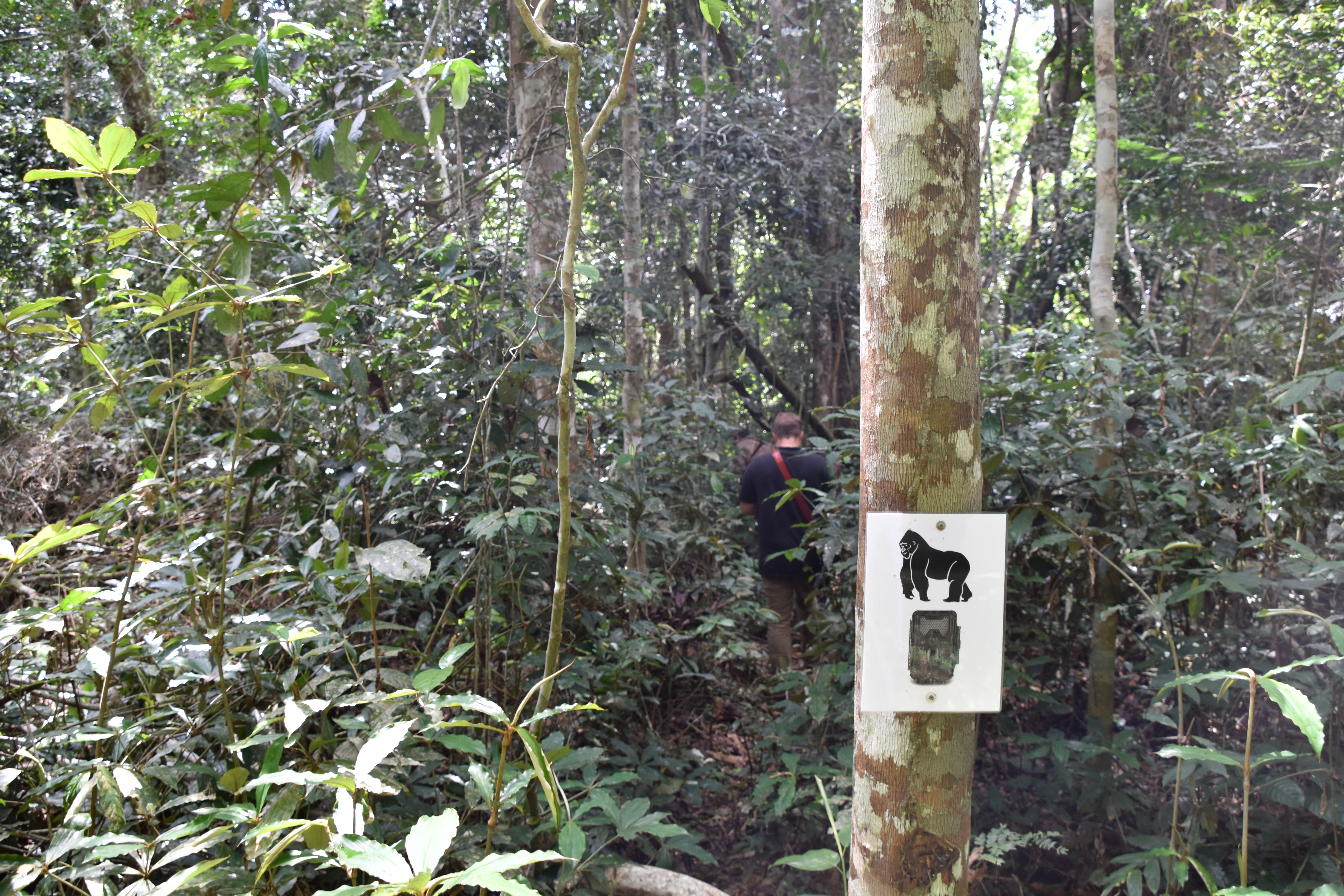
Geospatial data and analysis is critical for conservation, from planning to implementation and measuring success. Every day, mapping and spatial analysis are aiding conservation decisions, protected areas designation, habitat management on reserves and monitoring of wildlife populations, to name but a few examples. The Geospatial group focuses on all aspects of this field, from field surveys to remote sensing and data development/analysis to GIS systems.
How to Get Started
Want to learn more about how remote sensing is used in conservation? Check out the first two episodes of this season of Tech Tutors, where our Tutors answer the questions How do I use open source remote sensing data to monitor fishing? and How do I access and visualise open source remote sensing data in Google Earth Engine? You can also check out our Virtual Meetup Archive for a range of panels that overlap with Geospatial topics, or take a look at our Earth Observation 101 lecture series from Dr. Cristian Rossi.
Our Purpose
The WILDLABS Geospatial Group is for conservation practitioners, geospatial analysts, and academics that want to:
- Share geospatial resources, best practices, data, and ideas;
- Network amongst geospatial and data practitioners;
- Create peer learning opportunities;
- Promote the use of free and open-source geospatial software; and
- Improve the use of GIS software and geospatial analyses in conservation management and research.
Group curators

Over 35 years of experience in biodiversity conservation worldwide, largely focused on forests, rewilding and conservation technology. I run my own business assisting nonprofits and agencies in the conservation community


- 5 Resources
- 62 Discussions
- 12 Groups
- @ahmedjunaid
- | He/His
Zoologist, Ecologist, Herpetologist, Conservation Biologist


- 63 Resources
- 7 Discussions
- 26 Groups

Fauna & Flora
Remote Sensing Scientist, Conservation Technology & Nature Markets @ Fauna & Flora - WILDLABS Geospatial Group Co-Lead

- 34 Resources
- 28 Discussions
- 8 Groups

- @stienheremans
- | she/her
Remote sensing researcher for environmental monitoring and nature conservation/restoration
- 0 Resources
- 1 Discussions
- 5 Groups

Movement Ecologist studying the where, why, and how animals move throughout our world. Current work is investigating the movement and energetics of large neotropical bats in a changing environment with ephemeral resources.


- 0 Resources
- 23 Discussions
- 22 Groups

- @matt_hron
- | He/Him
Wildlife Protection Solutions (WPS)
Product Manager at Wildlife Protection Solutions


- 0 Resources
- 8 Discussions
- 8 Groups
- @tomwhite101
- | He/Him
Agroecology Geek
- 0 Resources
- 0 Discussions
- 12 Groups

BSc Forest Engineering, MSc GIS Sciences, Drone researcher
- 2 Resources
- 11 Discussions
- 5 Groups

University of British Columbia
Postdoc at UBC, exploring how drones enhance wildlife conservation using thermal cameras & AI tools to refine monitoring of large mammal populations in Canada & compare these approaches to traditional methods.
- 0 Resources
- 0 Discussions
- 7 Groups
- 0 Resources
- 0 Discussions
- 6 Groups

- @Kathinja
- | He
A Geography Graduate with a keen interest in Geographic Information systems(GIS), a climate enthusiast, sustainable development, conservation effort and green technologies
- 0 Resources
- 1 Discussions
- 7 Groups

Martin Wainaina Chege is a registered Geomatics Expert with experience in GIS software development, Remote sensing, Surveying, and Environmental and Social Impact Assessment (ESIA) with theoretical knowledge, technical and practical skills in IoT, Software Engineering, data

- 1 Resources
- 7 Discussions
- 5 Groups

Cornell University

- 0 Resources
- 0 Discussions
- 12 Groups

- @ImaniWilson
- | She / Her
Zoology with a placement year graduate from Bangor University. Interested in large African mammal movement and behaviour in response to climate change, particularly African elephants
- 0 Resources
- 0 Discussions
- 13 Groups

Royal Society for the Protection of Birds (RSPB)

- 1 Resources
- 18 Discussions
- 4 Groups
Link
Survey on Earth Observation in Wildlife Ecology
Helena Wehner
Hi together, I am working on detecting causalities between land surface dynamics and animal movement by using satellite-based earth observation data. As this is might be your expertise I kindly ask for your support...
8 May 2025

Article

Fires in Serengeti and Masai Mara National Parks have burned massive areas this year. With Google Earth Engine, it's possible to quantify burn severity using the normalized burn ratio function, then calculate the total...
29 April 2025
Article
A fascinating journey of unleashing my potentials in spatial analysis using ArcGIS Pro and R programming.
20 April 2025
Careers
Enterprise Geospatial Undergraduate Intern
World Wildlife Fund
WWF’s Compass community provides network-coordinated, cutting-edge data and analytics that enable effective conservation decision making, policy, advocacy and monitoring for WWF. The intern will collaborate with members...
18 April 2025
Careers

White-tailed eagle recovery across multi-use landscapes in England
8 April 2025
Article
Driving off-highway vehicles (OHVs), which contributes to habitat degradation and fragmentation, is a common recreational activity in the United States and other parts of the world, particularly in desert environments...
8 April 2025
Funding

The Airbus Foundation, in partnership with the Solar Impulse Foundation and Space4Good, has launched a Call for Projects to support initiatives using aerospace technology to enhance nature-based climate resilience. This...
4 April 2025
Funding
Multiple grants

Frank van der Most
I have been a bit distracted the past months by my move from Costa Rica to Spain ( all went well, thank you, I just miss the rain forest and the Ticos ) and have to catch up on funding calls. Because I still have little...
28 March 2025

AMMonitor 2
16 March 2025
AMMonitor
16 March 2025
Link
mapmixture (R package).
16 March 2025
June 2025
event

Joel Masselink
October 2025
event

Lacey Hughey and 3 more
November 2025

December 2023

126 Products
Recently updated products
| Description | Activity | Replies | Groups | Updated |
|---|---|---|---|---|
| Hi everyone, I seek your help for the choice of my thesis subject, I hold a Master's degree in Management of protected areas and I have... |
|
Camera Traps, Data management and processing tools, Protected Area Management Tools, Geospatial | 2 years 4 months ago | |
| I just came across this interesting paper in which seismic monotoring of animals like elephants was mentioned. This is the study refered to:Cheers,Lars |
|
AI for Conservation, Camera Traps, Emerging Tech, Ethics of Conservation Tech, Human-Wildlife Conflict, Geospatial, Sensors | 2 years 5 months ago | |
| Hi Steph. Would be interested also. |
|
Animal Movement, Community Base, Connectivity, Data management and processing tools, Emerging Tech, Geospatial | 2 years 5 months ago | |
| Thanks so much!! |
|
Acoustics, AI for Conservation, Animal Movement, Camera Traps, Community Base, Data management and processing tools, Drones, eDNA & Genomics, Emerging Tech, Open Source Solutions, Geospatial, Software Development | 2 years 7 months ago | |
| Hello. I am a PhD candidate at Penn State University. I submitted a post to this group back in March and I am resubmitting... |
|
Community Base, Data management and processing tools, Geospatial, Wildlife Crime | 2 years 8 months ago | |
| HI benard sorry am replying late,and yes i the data was exported as shapefile 2.i used same projection which is 37N WGS 84 on both apps and still the exported shape file... |
|
Geospatial, East Africa Community | 2 years 9 months ago | |
| @gracieermi & I are happy to announce the latest update to the Conservation Tech Directory, bringing our total resources in the... |
|
Acoustics, AI for Conservation, Animal Movement, Camera Traps, Community Base, Data management and processing tools, Drones, eDNA & Genomics, Geospatial, Software Development | 2 years 10 months ago | |
| Hey all! Just thought I would share the link to this wonderful new issue of National Geographic. Very powerful data visualisation of some... |
|
Geospatial | 3 years ago | |
| This earth day 2022 celebration blog recaps some of the available resources from organizations that are partnering with the NICFI Satellite Data Program. The platforms, tools... |
|
Geospatial | 3 years 1 month ago | |
| Can also recommend looking into Argos: https://www.cls-telemetry.com/argos-solutions/argos-services/ The transmitter can send a few messages per day and the messages are... |
+5
|
Geospatial, Connectivity | 3 years 1 month ago | |
| I think it looks like a really interesting technology, but it's still in the realm of research and academia. They're correct in that it demonstrates device miniaturization... |
|
Geospatial | 3 years 7 months ago | |
| Geospatial data engineer at Salo Sciences - https://salo.ai/assets/pdf/Data%20Engineer%20%E2%80%93%20Salo%20Sciences%20(Jul%202021).pdf... |
|
Geospatial | 3 years 9 months ago |


Conservation remote sensing webinar series

5 October 2018 7:40am
WILDLABS TECH HUB Showcase
 WILDLABS Team
17 May 2019 12:00am
Meet the WILDLABS TECH HUB Winners

13 May 2019 12:00am
Google 2019 Geo for Good Summit—apply before May 3

22 April 2019 6:43pm
FOSS4G 2019
12 April 2019 9:36am
#Tech4Wildlife Photo Challenge: Our Favourites from 2019
3 March 2019 12:00am
Eye on Earth Symposium Online: All 36 sessions will be webcast globally

5 October 2018 10:36am

18 February 2019 10:37am
Following the successful Eye on Earth Symposium at the end of October, the team has announced that video recordings of all 35 sessions are now available.
They've also shared a recording of the Global Environmental Education Partnership webinar: http://bit.ly/EoeWebinars
Sumatran Forest Type Maps and Data

9 January 2019 5:43pm

14 January 2019 10:26am
Just to throw a couple options out there:
The hanson map, which you can download from:
Global Land Analysis and Discovery
You could also make your own map from the raw satellite data but that is a bit more involved.
Tom
A technologist's journey to protect wildlife: The reality and potential of conservation technology (recorded talk)

22 November 2018 12:00am
GIS Day 2018
14 November 2018 7:48pm
WILDLABS Virtual Meetup Recording: Next Generation Wildlife Tracking
WILDLABS Team
12 November 2018 12:00am
Invitation to Contribute to the ISPRS SC Newsletter

28 August 2018 3:12pm

13 September 2018 3:24pm
Hi Sheryl,
This sounds great, thank you for sharing! As you may be aware, we had the UK National Earth Observation Conference 2018 here in the UK just last week (and you can see the abstracts here).
I'll share your call for submissions with colleagues in the Cambridge conservation community, noting your September 21st deadline.
Best wishes,
Thom

18 September 2018 11:58am
Hi Thom,
Thanks a lot for the response! The abstracts were very interesting and I hope we can share more of the work from you and your colleagues.
Please feel free to send me a message or an email regarding this matter.
All the best and thanks,
Sheryl
NASA Webinar: Change Detection for Land Cover
14 September 2018 3:55pm
Next Generation Animal Tracking Ideation Challenge

14 September 2018 12:00am
Compendium of guidance on key global databases related to biodiversity related conventions
13 September 2018 3:38pm
Is anyone using off-the-shelf GIS data collection apps? e.g. Collector for ArcGIS
8 March 2018 5:11pm
14 March 2018 11:28pm
So Collector is really for editing data, or adding GIS info in the field in a map interface. Works offline. It's ok for that purpose, you can take your entire map, basemap offline to the field, you can see what data has been collected in real-time, but can be buggy and if you accidentelly log out you're completely out of luck with no connection.
I use it to track drone flights - i.e. I flew here, with some notes.
Survey123 is ESRI's solution for ODK or form based surveys. I like it a lot, it's flexible, you don't need people to log in and it just looks better than ODK and works on iOS, and doesn't require the annoying server set-up of ODK and has great offline capability. But it's form-based, you don't really see the data you are editing in a map. But the best part are the analysis features where you can see stats on responses and such.
Let me know if you have more questions, we have used survey123 extensively, also in places where people have limited cell network, and limited knowledge of smartphones.
28 March 2018 12:40pm
Hi Steve,
Over on Twitter, @RLong has a suggestion that might be useful?
Dave Moskowitz https://t.co/ZJhAPTgzyx has developed some @ESRI Collector workflows for his work with @ConservationNW. You might get in touch with one of them for advice.
— Robert Long (@RLongEco) March 28, 2018
James Bevan also has some feedback:
I’ve used iGIS quite a bit to map points, lines and polygons. Created shapefiles can be emailed or stored in Dropbox and transferred to ArcGIS. The paid version also can calculate area and distance. Cons: somewhat fiddly to use.
— James Bevan (@JamesRBevan) April 9, 2018
Cheers
Steph

24 August 2018 5:18pm
Hi Steve,
I have used GIS Pro by Garafa on an iPad. I found it was one of the only apps that allowed importing of custom raster images. This feature has allowed me to take an image into the field, and ditize on it directly. I am mapping individual trees in airborne remote sensing data, so accurate digitizatoin with reference to my specific image is a must.
Other useful features are that you can create and edit vectors (points, lines, and polygons) and you cache basemaps (Google, Bing...) to work offline.
Happy to talk more about my application and experience with this app.
- Sarah
Spacewalk for ICARUS
24 August 2018 12:00am
How to share data on species to help conserve them… whilst avoiding them being exploited by poachers
20 August 2018 12:00am
Ocean Hack: San Francisco, 10-11th September, 2018
 One Ocean Collab
20 August 2018 12:00am
$90K in grants from the Con X Tech Prize
11 June 2018 12:00am
Webinar: Artificial Intelligence for Earth, Microsoft Research
 Eye on Earth Alliance
23 April 2018 12:00am
Conservation Technology User Guidelines Issue 4: Satellite remote sensing for conservation
23 April 2018 12:00am
#Tech4Wildlife Photo Challenge 2018: Our Top 10
3 March 2018 12:00am
Landsense Innovation Challenge
19 February 2018 12:00am
Technology Empowered Conservation Lecture Series
18 January 2018 12:00am
ESA Space Hack: 17-19th Nov (Helsinki)
30 October 2017 10:20am
Download New Conservation Tech Guidelines: Camera Traps, Acoustics and LiDAR
11 October 2017 12:00am
Learning and Training Resources for GIS - contributions welcome!
19 June 2017 3:09pm
19 June 2017 3:11pm
I wrote an article on Conservation Careers earlier this year on 13 Short Online Course Ideas to Boost Your GIS Career. I'm thinking of adding to this article with some additional courses that have come up recently, or creating a 'sequel' article. If people wanted to contribute then I'd be happy to cite individuals or the WILDLABS Community.
19 June 2017 3:17pm
Thanks for starting this thread, @Thomas+Starnes !
I posted the following twitter conversation in the original Remote Sensing resources thread, yet I think it's possibly more applicable to this thread so am resharing it to make sure it's easily accessible for anyone else looking for GIS specific info in the future.
Does anyone know of good, free resources for learning to use GIS software? (preferably QGIS) #movementecology
— Stuart Watson (@SkipsAhoi) April 24, 2017
My former uni had a subscription to the QGIS Lynda course which was immensely helpful... may be worth checking https://t.co/sDywDX8Y5b
— Arjun Dheer (@ArjDheer) April 24, 2017
Our gentle intro to #GIS should get you started https://t.co/O87TJiz2zy
— QGIS (@qgis) April 24, 2017
There are some great links here: https://t.co/0T2gHoZ0We. Youtube also has excellent tutorials: https://t.co/x8IkUVqc8O. #mapping #gis #qgis pic.twitter.com/JysA4Din63
— WAAS International (@WAASInt) April 27, 2017
— Gerry Ryan (@silverlangur) June 19, 2017
9 October 2017 12:11pm
Hi all,
I just wanted to draw your attention to the new OS Geo UK Training page. This is a really helpful list of GIS training courses on offer in the UK. Anyone can contribute to the list via GitHub.
Thom
Alternatives to shapefiles
11 September 2017 1:34pm
13 September 2017 5:17pm
This is a very good question, @spritchard, and not one specific to the conservation community. I'd suggest maybe also posting on GIS StackExchange? The shapefile has come to be the standard vector exchange format, but you're right that it's actually proprietary. I guess geoJSON is the open source equivalent and it is actually supported in some Esri applications e.g. ArcGIS Server and ArcGIS Online.

19 September 2017 8:04pm
Geopackage and geoJSON for general GIS purpose (the fisrt is particularly optimal for storage and sharing) and sf (stands for simple feature) for R environment spatial data manipulation.
4 October 2017 9:34am
I don't think there is an open like for like replacement. I normally work with ESRI software so mainly use Geodatabases now.
Open options are really in the web format realm (GeoJson) or database (PostGIS, SQLLite, SpatialLite. Also there is KML
DAS: A Scaleable Solution For Protected Area Management
26 September 2017 12:00am
3 June 2019 11:20am
CBI and SCGIS have been running a second series of webinars this year. You can find recordings of all the previous webinars signposted here.
Of note, see:
The Potential of GEDI Lidar for Biodiversity Conservation Applications
The next upcioming webinar is Integrating Remote Sensing With Conservation Analysis Workflows on June 11, 10:00 PDT (register here).