Group curators

Vance Russell

Ahmed Junaid
- @ahmedjunaid
- | He/His

Elsa Carla De Grandi
Fauna & Flora
Who We Are
Geospatial data and analysis is critical for conservation, from planning to implementation and measuring success. Every day, mapping and spatial analysis are aiding conservation decisions, protected areas designation, habitat management on reserves and monitoring of wildlife populations, to name but a few examples. The Geospatial group focuses on all aspects of this field, from field surveys to remote sensing and data development/analysis to GIS systems.
How to Get Started
Want to learn more about how remote sensing is used in conservation? Check out the first two episodes of this season of Tech Tutors, where our Tutors answer the questions How do I use open source remote sensing data to monitor fishing? and How do I access and visualise open source remote sensing data in Google Earth Engine? You can also check out our Virtual Meetup Archive for a range of panels that overlap with Geospatial topics, or take a look at our Earth Observation 101 lecture series from Dr. Cristian Rossi.
Our Purpose
The WILDLABS Geospatial Group is for conservation practitioners, geospatial analysts, and academics that want to:
- Share geospatial resources, best practices, data, and ideas;
- Network amongst geospatial and data practitioners;
- Create peer learning opportunities;
- Promote the use of free and open-source geospatial software; and
- Improve the use of GIS software and geospatial analyses in conservation management and research.
Group curators

Over 35 years of experience in biodiversity conservation worldwide, largely focused on forests, rewilding and conservation technology. I run my own business assisting nonprofits and agencies in the conservation community


- 5 Resources
- 62 Discussions
- 12 Groups
- @ahmedjunaid
- | He/His
Zoologist, Ecologist, Herpetologist, Conservation Biologist


- 63 Resources
- 7 Discussions
- 26 Groups

Fauna & Flora
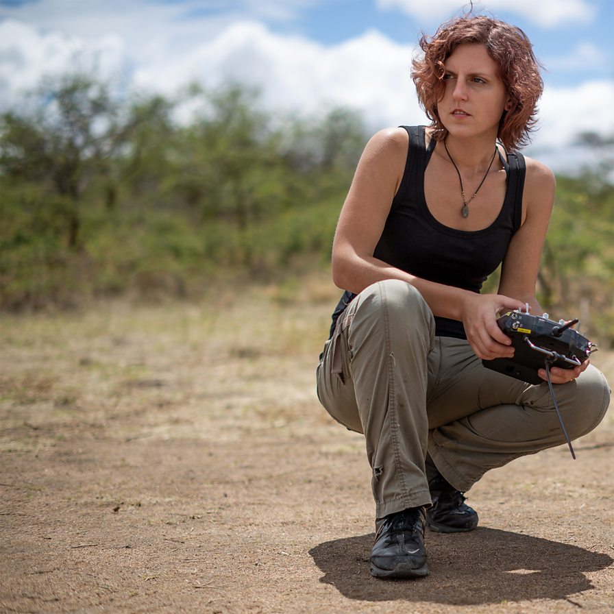
Remote Sensing Scientist, Conservation Technology & Nature Markets @ Fauna & Flora - WILDLABS Geospatial Group Co-Lead

- 34 Resources
- 28 Discussions
- 8 Groups

Aeracoop & Dronecoria
Computer engineer, Drone Pilot, Seed researcher, Wild Tech Maker


- 3 Resources
- 37 Discussions
- 11 Groups

- @Durgananda
- | He
- 0 Resources
- 0 Discussions
- 20 Groups

Earth Logic LLC
- 2 Resources
- 1 Discussions
- 1 Groups

Natural Solutions
- 0 Resources
- 13 Discussions
- 10 Groups

Chartered Geographer and Fellow of the Royal Geographical Society. 35 years in GIS, currently Nature Products Lead at CreditNature. Main interests: biogeography, biodiversity, ecosystem integrity, ecosystem services, rewilding, nature tech, nature fintech.

- 0 Resources
- 1 Discussions
- 3 Groups

- @hjayanto
- | He/Him
KONKLUSI (Kolaborasi Inklusi Konservasi - Yayasan)
Your friendly Indo-Crocky-Croc


- 0 Resources
- 44 Discussions
- 17 Groups

- @MStarking
- | she/her/hers
Ecologist and conservation researcher, currently an Assistant Professor at University of Michigan-Flint, research areas include landscape ecology, forestry and wildlife interactions, wildlife habitat relationships, spatial ecology, GIS.
- 0 Resources
- 1 Discussions
- 15 Groups

- 0 Resources
- 0 Discussions
- 1 Groups

Wildlife Conservation Society (WCS)
I am a devoted conservationist, natural resource management enthusiast interested in Elephant and Pangolin species and passionate about linking communities with environmental conservation
- 1 Resources
- 0 Discussions
- 13 Groups

Software Developer, Teacher and Technical Trainer. Passionate about using tech for good
- 0 Resources
- 7 Discussions
- 7 Groups

Technical Specialist at FFI: loves data management, maps, remote sensing & GIS for conservation


- 2 Resources
- 2 Discussions
- 9 Groups

- @rowan
- | they / them
Octophin Digital
Jack of all Trades. I've been a zoo keeper, a conservation geneticist and a web developer who specialises in conservation projects and orgs.
- 1 Resources
- 5 Discussions
- 15 Groups
Careers
Conservation Technology Specialist

Wildlife Conservation Society (WCS)
WCS is seeking a Conservation Technology Specialist to join their work in the Okapi Wildlife Reserve.
11 August 2023
Careers
Deadline Approaching: GIS Capacity Internship
Meredith Palmer
We're looking for an enthusiastic early career individual looking to develop their GIS, remote sensing, and capacity building skills.
24 July 2023
Article
Conservation StoryMap competition

Adrian Hughes
ESRI and IUCN have teamed up to launch a StoryMap competition. Storytellers are invited to share stories on a range of conservation topics including technological innovation, ecological corridors and initiatives by...
17 July 2023
Link

Here's an interesting new paper in Nature about how new techniques in machine learning and satellite remote sensing are allowing researchers to monitor and count large populations of migratory terrestrial mammals like...
11 July 2023
Link
We've published a paper on the role of low-code Earth observation tools in the sustainability transition. It covers how different roles in a business like analysts and executives can benefit from this tech and how it...
30 June 2023
Careers
Due Diligence Technical Specialist - Climate Impact Partners

Esther Githinji
Climate Impact Partners are looking for a Due Diligence Technical Specialist to join their supply-side team for an opportunity to carry out DD on projects, at a leading provider of high-quality carbon credit programmes.
27 June 2023
Funding

JICA, Japan’s International Cooperation Agency is seeking a digital partner with a proven track record in conservation technology as we launch a pilot project to test technologies to mitigate human-elephant conflict in...
19 June 2023
Careers
GIS Application Specialist in Nairobi, DGB Group
Esther Githinji
If you have a strong background in GIS, a passion for environmental sustainability, and the desire to contribute to the world's carbon neutrality, this is a great opportunity for you!
15 June 2023
Careers
Fisheries Analyst (Pacific)

Global Fishing Watch
With a focus on using and combining vessel tracking data, other satellite derived datasets and big data methods and AI generated estimates related to vessel identity and activity, the Fisheries Analyist with Global...
15 June 2023
Careers

Come work with us! WILDLABS and Fauna & Flora are seeking an intern to help develop the movement ecology content on the Inventory - our wiki-inspired database of conservation technology. Accepting applications until...
6 June 2023
Careers
Natural Capital GIS & Data Administrator
Esther Githinji
The Future Forest Company (FFC) team are looking for an enthusiastic, early career data and GIS administrator to join them. The role will manage spatial and operational data, with a particular focus on carbon from...
31 May 2023
Link

Climasens’ platform is now being used by Australian Councils to support disaster resilience efforts. It’s inaugural product, HeatSens, is being used to bridge the gap between emergency management and climate change...
30 May 2023
June 2025

event

Joel Masselink
October 2025
event

Lacey Hughey and 3 more
November 2025

January 2025
event

Ben Weinstein
December 2024

November 2024
event

Cassie Anderson
126 Products
Recently updated products
| Description | Activity | Replies | Groups | Updated |
|---|---|---|---|---|
| Hi everyone, I’m excited to become a member of Wild Lab! I’m currently working on my master’s thesis, focusing on dormouse conservation. My research explores the behavioral... |
|
AI for Conservation, Animal Movement, Camera Traps, Citizen Science, Community Base, Data management and processing tools, Early Career, Geospatial | 2 months 1 week ago | |
| Hello! I'm wondering whether there's anyone on here who would be able to offer me some guidance on storing spatial data in Microsoft Azure... |
|
Geospatial | 4 months 2 weeks ago | |
| Thank you! I will follow up by email. |
+8
|
Animal Movement, Conservation Dogs, East Africa Community, Geospatial, Sensors, Women in Conservation Tech Programme (WiCT) | 2 months 1 week ago | |
| Thanks @VAR1 great insights! Funny you mentioned the honey thing, @hikinghack said the same in response on the GOSH forum. I think the point I'm trying to make with the vegan... |
|
Open Source Solutions, AI for Conservation, Conservation Tech Training and Education, Ethics of Conservation Tech, Geospatial, Software Development | 2 months 2 weeks ago | |
| How much does it cost to incorporate machine learning into your conservation drone geospatial analysis? How does it speed up your workflow... |
|
Conservation Tech Training and Education, Drones, Geospatial, Open Source Solutions, Sensors, Software Development | 2 months 3 weeks ago | |
| Hi Dan, Not right now but I can envision many uses. A key problem in RS is data streams for validation and training of ML models, its really not yet a solved problem. Any... |
|
Emerging Tech, AI for Conservation, Animal Movement, Build Your Own Data Logger Community, Camera Traps, Connectivity, Conservation Tech Training and Education, Data management and processing tools, Geospatial, Sensors | 3 months ago | |
| And if you are new to GFW...this new glossary that was added recently is very helpful to understand some key terms.Check it out here! |
|
Geospatial | 3 months ago | |
| I agree Adventina. I am also interested in "How has the climate variability affected the trend of BAT species in the ecosystem? and respond on their increase and (or) extinction.... |
|
Climate Change, Community Base, Geospatial, Women in Conservation Tech Programme (WiCT) | 3 months 1 week ago | |
| Kasi, Thanks for sharing the excellent blog on elephant collaring. The map at the end was interesting. Did you do further... |
|
Geospatial | 3 months 3 weeks ago | |
| We're extending the survey deadline! Please don't forget to let us know if you would like to speak about your work at one of the future Geospatial community events. Many... |
|
Geospatial | 3 months 3 weeks ago | |
| @cmwainaina check this out |
|
Drones, Conservation Tech Training and Education, Geospatial | 4 months ago | |
| Thank you David, a phenomenal source! |
+10
|
Drones, Geospatial, Protected Area Management Tools | 4 months 2 weeks ago |


Fellowship Opportunity: Planet Labs and Taylor Geospatial Institute 🚀
11 January 2025 5:37pm
DeepForest Code Walkthrough - Airborne Machine Learning for Biodiversity Monitoring
6 January 2025 3:24pm
Recommended Hardware to stitch together Drone Imagery into Orthomosaics

25 November 2024 6:25am

3 January 2025 3:41am
Hi @willrippon, I've worked with 3D reconstruction systems (software and hardware) for over 10 years now, and lately I've been really pleasantly surprised by Pix4D.
Here is a demo for a landscape survey my company just did.
Here is a 300 MB orthomosaic we just got as well.
Here is the hardware workflow described in detail.
On top of the drone imagery, we did "post-processing kinematics" (PPK) of the drone images (a very important thing to do, otherwise photogrammetry quality really suffers). I'm happy to discuss workflow further, and plan to release open source code and services.
If nothing else, go with Pix4D.

6 January 2025 7:40am
Thank you David, a phenomenal source!
Photogrammetry of Coral Reef Breakwaters

20 December 2024 1:11am

22 December 2024 8:35am
Hi Matthew
Wow, what an amazing project! It is incredible how you have managed to figure out some of the complexities of combining underwater imagery with UAV imagery. I am sure that was a fascinating learning experience.
I cannot help you with Points 1 and 3 but can suggest using Orfeo Toolbox for your segmentation process in Point 2. It integrates with QGIS and is open source. It will work with your UAV ortho maps if there is enough visible detail of the corals. You will be able to build and train your own model in order to accurately segment you reef. It takes a bit of know how to us the Machine Learning algorithms but once you get the hang of it it becomes immensely powerful. I will be building an online course on how to build your own machine learning processing algorithms in 2025 using this brilliant package. Once segmented you can save out the shapefiles and use them to segment and define your 3D point clouds in Agisoft.
Alternatively, look into using Picterra Geospatial AI. It is cloud based and much simpler to use but you may need to compress your imagery or point clouds in order to upload them given the file size you mentioned above. (Although they probable do allow for large uploads these days, I used Picterra in the past and it was brilliant!). Also i am not sure if it works with point clouds directly but have a look
I hope this helps. Great project!
Postdoc on camera trapping, remote sensing, and AI for wildlife studies
18 December 2024 2:14pm
FEISTY Fortran library and R package to integrate fish and fisheries with biogeochemical models
Query Regarding ArcMap
15 November 2024 2:21pm

12 December 2024 1:19pm
Sure
12 December 2024 1:20pm
I'll see that but I actually prefer ArcMap so that's why
12 December 2024 1:22pm
Thankyou so much. I'll definitely apply these solutions
Advancements and Applications of Drone-Integrated Geographic Information System Technology—A Review
Is there relation between Economic GDP and Geospatial tools?
12 November 2024 9:54am
2 December 2024 11:16am
Thank you so much Vance, this is very helpful information.
2 December 2024 11:23am
This's insightful idea, thanks Tim.
2 December 2024 11:23am
Very helpful.
Made 4 Geek
30 November 2024 7:29am
Made 4 Geek - YouTube
My YouTube channel aims to share tutorial videos, to make it easy to understand.

Geospatial Analysis using Python and QGIS Training Workshop

29 November 2024 12:30pm
Basics to Mastery: The Ultimate Course on Statistical Methods in R
27 November 2024 4:17pm
Online Course: Statistical Methods in R
The Ultimate Course to Quickly Master Statistical Methods in R - Instructor: Joachim Schork - Statistics Globe

High-resolution sensors and deep learning models for tree resource monitoring
25 November 2024 9:14pm
High-resolution sensors and deep learning models for tree resource monitoring | Nature Reviews Electrical Engineering
Trees contribute to carbon dioxide absorption through biomass, regulate the climate, support biodiversity, enhance soil, air and water quality, and offer economic and health benefits. Traditionally, tree monitoring on continental and global scales has focused on forest cover, whereas assessing biomass and species diversity, as well as trees outside closed-canopy forests, has been challenging. A new generation of commercial and public satellites and sensors provide high-resolution spatial and temporal optical data that can be used to identify trees as objects. Technologies from the field of artificial intelligence, such as convolutional neural networks and vision transformers, can go beyond detecting these objects as two-dimensional representations, and support characterization of the three-dimensional structure of objects, such as canopy height and wood volume, via contextual learning from two-dimensional images. These advancements enable reliable characterization of trees, their structure, biomass and diversity both inside and outside forests. Furthermore, self-supervision and foundation models facilitate large-scale applications without requiring extensive amounts of labels. Here, we summarize these advances, highlighting their application towards consistent tree monitoring systems that can assess carbon stocks, attribute losses and gains to underlying drivers and, ultimately, contribute to climate change mitigation. Trees are crucial for Earth’s ecosystems, aiding in carbon absorption, climate regulation and biodiversity support. High-resolution satellite sensors and artificial intelligence enable detailed tree monitoring at national and continental levels, simplifying biomass assessment, national reporting and climate change mitigation efforts.

AmazonTEC: 4D Technology for Biodiversity Monitoring in the Amazon (English)
25 November 2024 8:33pm
Technology solutions used by countries in UNFCCC reference levels
25 November 2024 8:11pm

Geospatial Scientist at Treeconomy
18 November 2024 10:02pm
GIS Day
18 November 2024 4:13pm
GIS Day | November 19, 2025
Celebrate GIS excellence on GIS Day. Use our free resources to plan activities that teach, motivate, and inspire others to explore all that GIS can do.

TorchGeo: Deep Learning With Geospatial Data
16 November 2024 5:20pm
[2111.08872] TorchGeo: Deep Learning With Geospatial Data
Abstract page for arXiv paper 2111.08872: TorchGeo: Deep Learning With Geospatial Data

21 December 2024 5:21am
This site may be of use for WebODM and photogrammetry using UAVs, as it focuses purely on processing that type of data and the hardware required. It also covers Conservation and Agriculture analysis and training using open source GIS and 3D point cloud software. Follow the links below:
https://www.geowingacademy.com
Hope this helps.