Group curators

Vance Russell

Ahmed Junaid
- @ahmedjunaid
- | He/His

Elsa Carla De Grandi
Fauna & Flora
Who We Are
Geospatial data and analysis is critical for conservation, from planning to implementation and measuring success. Every day, mapping and spatial analysis are aiding conservation decisions, protected areas designation, habitat management on reserves and monitoring of wildlife populations, to name but a few examples. The Geospatial group focuses on all aspects of this field, from field surveys to remote sensing and data development/analysis to GIS systems.
How to Get Started
Want to learn more about how remote sensing is used in conservation? Check out the first two episodes of this season of Tech Tutors, where our Tutors answer the questions How do I use open source remote sensing data to monitor fishing? and How do I access and visualise open source remote sensing data in Google Earth Engine? You can also check out our Virtual Meetup Archive for a range of panels that overlap with Geospatial topics, or take a look at our Earth Observation 101 lecture series from Dr. Cristian Rossi.
Our Purpose
The WILDLABS Geospatial Group is for conservation practitioners, geospatial analysts, and academics that want to:
- Share geospatial resources, best practices, data, and ideas;
- Network amongst geospatial and data practitioners;
- Create peer learning opportunities;
- Promote the use of free and open-source geospatial software; and
- Improve the use of GIS software and geospatial analyses in conservation management and research.
Group curators

Over 35 years of experience in biodiversity conservation worldwide, largely focused on forests, rewilding and conservation technology. I run my own business assisting nonprofits and agencies in the conservation community


- 5 Resources
- 62 Discussions
- 12 Groups
- @ahmedjunaid
- | He/His
Zoologist, Ecologist, Herpetologist, Conservation Biologist


- 63 Resources
- 7 Discussions
- 26 Groups

Fauna & Flora
Remote Sensing Scientist, Conservation Technology & Nature Markets @ Fauna & Flora - WILDLABS Geospatial Group Co-Lead

- 34 Resources
- 28 Discussions
- 8 Groups

- @ahmed_fuad
- | he/him
CEO & Co-Founder of SpaceIn. Using geospatial data and computer systems to tackle environmental issues.
- 0 Resources
- 0 Discussions
- 3 Groups

- @EllieW
- | She/Her


- 88 Resources
- 123 Discussions
- 14 Groups

Passionate about deciphering patterns from complex datasets, I am a skilled data analyst with a keen eye for detail and a knack for transforming raw information into actionable insights. With a solid foundation in statistical analysis, and data visualization.
- 0 Resources
- 0 Discussions
- 1 Groups

- @billardball8
- | She/Her
- 0 Resources
- 0 Discussions
- 6 Groups

- @Godwin
- | Mr
Student at University of Dar es Salaam Taking Bachelor Degree in Electronics Enginneering
- 0 Resources
- 0 Discussions
- 2 Groups
- @annie2
- | she/her
- 0 Resources
- 0 Discussions
- 16 Groups
- @jahiyaclark
- | she/her
PhD Student at UCSC Ecology and Evolutionary Biology
- 0 Resources
- 0 Discussions
- 6 Groups
- 0 Resources
- 1 Discussions
- 6 Groups
- @Diep
- | Ms


- 8 Resources
- 0 Discussions
- 4 Groups

- @jsevans
- | He, Him
Senior biometrician, with the Nature Conservancy science team, attempting to bring vigor from diverse fields such as landscape ecology, spatial statistics, remote sensing and applied mathematics to answer practical conservation questions.
- 0 Resources
- 0 Discussions
- 7 Groups
- 0 Resources
- 0 Discussions
- 4 Groups

- @shahselbe
- | he/him
Conservify
Conservation Technologist, National Geographic Explorer, and Founder of Conservify and FieldKit
- 0 Resources
- 5 Discussions
- 18 Groups
Link
Collaring Elephants and Post Release Monitoring
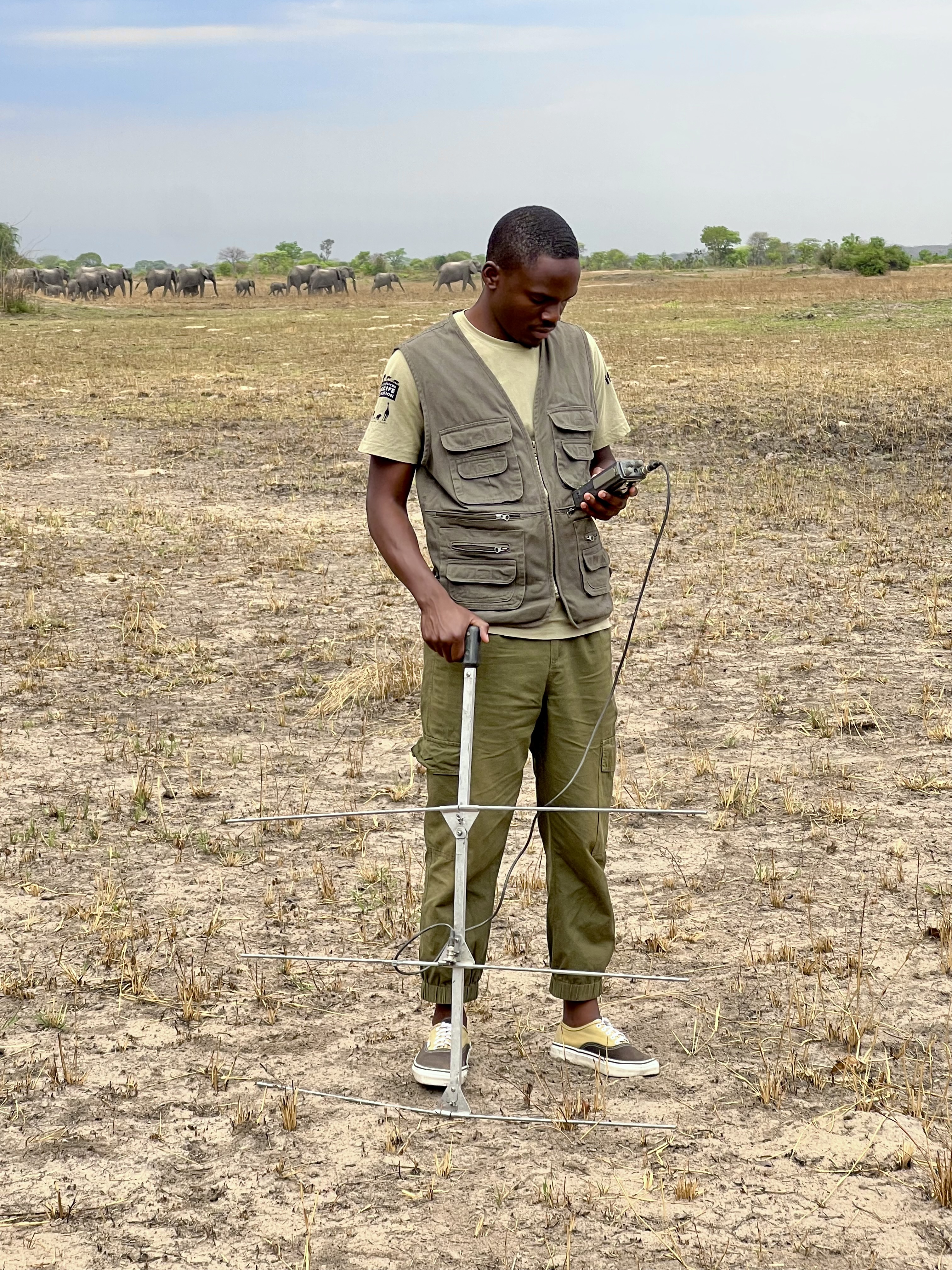
Kasi Amor Kalande
This leads to an exciting blog we did recently, it also includes a spatial map indicating elephant movement tracks of an orphaned elephant who self released himself into the wild (Kafue National Park). Cartography was...
28 January 2025
Careers
Geospatial Guru: Mapping a Better Future

Elsa Carla De Grandi
Remote, United Kingdom
27 January 2025
Link
Early Wildfire Smoke Detection Method Based on EDA

Ahmed Junaid
https://doi.org/10.3390/rs16244684
27 January 2025
https://doi.org/10.1098/rstb.2023.0327
26 January 2025
Link
Nature Climate Change (2025).
26 January 2025
Link

Updated version of the Spatial Database of Planted Trees (SDPT), which differentiates planted forests and tree crops from primary and secondary natural forests. Update has double the number of countries covered
25 January 2025
Link
New Data Provides First Global Annual Picture of Cultivated and Natural Grasslands

Elsa Carla De Grandi
The Land & Carbon Lab developed a new dataset that provides global maps of grassland extent annually from 2000 - 2022 at a 30 m resolution. These maps are critical for tracking changes in grassland ecosystems,...
25 January 2025
Article

Over the years, a large number of developments have gone up in the area that I live in and the municipality is not doing what they should when it comes to upholding the laws that have been put in place to protect the...
20 January 2025
Special Issue: Remote Sensing of Solar Radiation Absorbed by Land Surfaces
19 January 2025
Careers

The Department of Wildlife, Fish, and Environmental Studies (WFE), SLU, Umeå, is looking for a postdoc with strong interests in wildlife conservation technology.
15 January 2025
Link
Google Earth Engine Tutorial-100: Heatwave Mapping
Ahmed Junaid
Google Earth Engine with Amirhossein Ahrari
15 January 2025
June 2025
event

Joel Masselink
October 2025
event

Lacey Hughey and 3 more
November 2025

January 2023
126 Products
Recently updated products
| Description | Activity | Replies | Groups | Updated |
|---|---|---|---|---|
| Hi everyone, I seek your help for the choice of my thesis subject, I hold a Master's degree in Management of protected areas and I have... |
|
Camera Traps, Data management and processing tools, Protected Area Management Tools, Geospatial | 2 years 4 months ago | |
| I just came across this interesting paper in which seismic monotoring of animals like elephants was mentioned. This is the study refered to:Cheers,Lars |
|
AI for Conservation, Camera Traps, Emerging Tech, Ethics of Conservation Tech, Human-Wildlife Conflict, Geospatial, Sensors | 2 years 5 months ago | |
| Hi Steph. Would be interested also. |
|
Animal Movement, Community Base, Connectivity, Data management and processing tools, Emerging Tech, Geospatial | 2 years 5 months ago | |
| Thanks so much!! |
|
Acoustics, AI for Conservation, Animal Movement, Camera Traps, Community Base, Data management and processing tools, Drones, eDNA & Genomics, Emerging Tech, Open Source Solutions, Geospatial, Software Development | 2 years 7 months ago | |
| Hello. I am a PhD candidate at Penn State University. I submitted a post to this group back in March and I am resubmitting... |
|
Community Base, Data management and processing tools, Geospatial, Wildlife Crime | 2 years 8 months ago | |
| HI benard sorry am replying late,and yes i the data was exported as shapefile 2.i used same projection which is 37N WGS 84 on both apps and still the exported shape file... |
|
Geospatial, East Africa Community | 2 years 9 months ago | |
| @gracieermi & I are happy to announce the latest update to the Conservation Tech Directory, bringing our total resources in the... |
|
Acoustics, AI for Conservation, Animal Movement, Camera Traps, Community Base, Data management and processing tools, Drones, eDNA & Genomics, Geospatial, Software Development | 2 years 10 months ago | |
| Hey all! Just thought I would share the link to this wonderful new issue of National Geographic. Very powerful data visualisation of some... |
|
Geospatial | 3 years ago | |
| This earth day 2022 celebration blog recaps some of the available resources from organizations that are partnering with the NICFI Satellite Data Program. The platforms, tools... |
|
Geospatial | 3 years 1 month ago | |
| Can also recommend looking into Argos: https://www.cls-telemetry.com/argos-solutions/argos-services/ The transmitter can send a few messages per day and the messages are... |
+5
|
Geospatial, Connectivity | 3 years 1 month ago | |
| I think it looks like a really interesting technology, but it's still in the realm of research and academia. They're correct in that it demonstrates device miniaturization... |
|
Geospatial | 3 years 7 months ago | |
| Geospatial data engineer at Salo Sciences - https://salo.ai/assets/pdf/Data%20Engineer%20%E2%80%93%20Salo%20Sciences%20(Jul%202021).pdf... |
|
Geospatial | 3 years 9 months ago |