Because connectivity solutions are vital to so much of our conservation tech work, our Connectivity group unites users working across a variety of tech tools. Our community has often flagged connectivity as being extremely important to their work's success, yet the buzzword solutions like IoT and LoRa can be intimidating to conservationists who are new to the topic. In this is the catch-all space for discussing the wide range of communications networks that are becoming increasingly integral to retrieving data in modern conservation tech systems, we welcome beginners, experts, and everyone in between to get involved!
By connecting novices and experts to discuss and demystify connectivity in conservation tech, this group can serve as a place to learn and explore, with spaces to talk about recent progress and developments on the horizon, share resources to help others understand key connectivity issues and why it's relevant to their work, ask questions and troubleshoot, and much more.
Below, you'll find one of our Tech Tutors episodes introducing the subject of connectivity through a tutorial on LoRa:
Sean Sturley: How do I get started with LoRa? Connectivity in conservation
And here you'll find an episode on using satellite IoT:
Alasdair Davies: How do I use satellite IoT to track wildlife and monitor remote equipment?
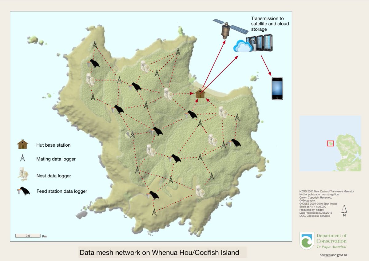
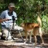
Finally, here's a great example of a multisensor network connecting devices across a landscape in New Zealand, courtesy of Andrew Digby (see original post here)
Header image: Njoroge Nyamu (see original post here)
No showcases have been added to this group yet.

- 0 Resources
- 0 Discussions
- 18 Groups

- @jcolombini
- | he/him
Electrical and Computer Engineer with a Msc in Robotics. Working on edge computing and adhoc networks for urban fauna conservation
- 0 Resources
- 2 Discussions
- 2 Groups

Sustainability Manager for CERES Tag LTD. An animal health company; animal monitoring, conservation, & anti-poaching/ rural crime. Wildlife, livestock, equine & companion. #CeresTrace #CeresWild #CeresRanch


- 2 Resources
- 20 Discussions
- 23 Groups

Universidad San Francisco de Quito
Biologist/Professor focusing on carnivore conservation in Ecuador
- 0 Resources
- 0 Discussions
- 11 Groups
- @johnjoseph
- | He/Him
I am a mechanical engineer with diverse industry experience and a passion for innovative technology. As a technology and engineering entrepreneur, I focus on creating solutions that blend advanced engineering with a commitment to nature and forest conservation.
- 0 Resources
- 0 Discussions
- 10 Groups

- @tkswanson
- | she/her
San Diego Zoo Wildlife Alliance
Research Coordinator II for the Conservation Technology Lab at SDZWA
- 2 Resources
- 2 Discussions
- 7 Groups
- @vfhawkinson
- | she/her
University of Washington
PhD student assessing multi-scalar livestock-wildlife interactions in the American West
- 0 Resources
- 1 Discussions
- 8 Groups
- 0 Resources
- 0 Discussions
- 5 Groups
Scaling biodiversity monitoring, using smart sensors and ai-pipelines
- 0 Resources
- 2 Discussions
- 10 Groups

- @StephODonnell
- | She / Her


- 196 Resources
- 676 Discussions
- 31 Groups

- @DeepakSathyanarayan
- | he/his
Deepak is an experienced professional who has served in multiple leadership roles in technology, science, product development, and engineering programs. He has proven expertise in shaping and executing technology strategies across defense, space, health, and environment sectors.

- 0 Resources
- 5 Discussions
- 7 Groups

Technical Specialist at FFI: loves data management, maps, remote sensing & GIS for conservation


- 2 Resources
- 2 Discussions
- 9 Groups
Careers

If you're a Post-Doctoral Fellow, a PhD student, or a member of the research staff interested in applying your computational skills to support active research publications, please read on to learn about the Cross-...
5 August 2025
Article
Driving off-highway vehicles (OHVs), which contributes to habitat degradation and fragmentation, is a common recreational activity in the United States and other parts of the world, particularly in desert environments...
8 April 2025
Funding

Osa Conservation is launching our inaugural cohort of the ‘Susan Wojcicki Research Fellowship’ for 2025, worth up to $15,000 per awardee (award value dependent on project length and number of awards given each year)....
10 February 2025
Article
INSTANT DETECT 2.0 - ALPHA TESTING

Sam Seccombe
The worst thing a new conservation technology can do is become another maintenance burden on already stretched field teams. This meant Instant Detect 2.0 had to work perfectly from day 1. In this update, Sam Seccombe...
28 January 2025
Article
INSTANT DETECT 2.0 – THE OPTIMISATION YEARS
Sam Seccombe
The Zoological Society of London's Instant Detect 2.0 is the world's first affordable satellite connected camera trap system designed by conservationists, for conservationists. In this update, Sam Seccombe describes the...
21 January 2025
Careers
The Smithsonian’s National Zoo & Conservation Biology Institute is seeking two Post-doctoral Research Fellows to advance research in the spatial ecology and conservation of bustard species with a special focus on...
11 November 2024
Careers
Internship - Predator Monitoring - South Africa

Loveness L Mutungi
Are you an aspiring wildlife conservationist with a passion for apex predators?, BushVeld Biodiversity Research Centre is looking for you!!!
30 July 2024
Careers
Area Manager for Baboon Management in Hermanus, South Africa.
Loveness L Mutungi
Human Wildlife Solutions is looking for you!!!. Send your application materials by 15th August 2024.
30 July 2024
Article
New WILDLABS Funding & Finance group

Frank van der Most
WildLabs will soon launch a 'Funding and Finance' group. What would be your wish list for such a group? Would you be interested in co-managing or otherwise helping out?
5 June 2024
Article

Are you passionate about marine wildlife conservation? Excited to network and collaborate with fellow enthusiasts? Join us in launching the Coastal and Marine Wildlife Working Group within The Wildlife Society!
23 May 2024
Article
Share Your Work in a Conservation Technology Video

Robin Marti Sarasa
Do you have photos and videos of your conservation tech work? We want to include them in a conservation technology showcase video
17 May 2024
Article
The Inventory User Guide

Jake Burton
Read in detail about how to use The Inventory, our new living directory of conservation technology tools, organisations, and R&D projects.
1 May 2024
August 2025
event

Louisa Richmond-Coggan
September 2025
event
Louisa Richmond-Coggan
event
Louisa Richmond-Coggan
October 2025
event

Lacey Hughey and 3 more
January 2025
event

Wildlife Drones
October 2024
| Description | Activity | Replies | Groups | Updated |
|---|---|---|---|---|
| Thank you for your reply, ChadI meant 10 as a whole, indeed. Perhaps you see your post in one group, but since it is tagged for all groups, I assumed you meant 10 in total.In your... |
|
Acoustics, AI for Conservation, Animal Movement, Camera Traps, Citizen Science, Climate Change, Community Base, Connectivity, Drones, eDNA & Genomics, Emerging Tech, Funding and Finance, Geospatial, Human-Wildlife Coexistence, Software Development, Wildlife Crime | 1 month 3 weeks ago | |
| Gina- Sounds like an interesting thesis topic! I work with bioacoustics in offshore waters and I'd be happy to have a chat and provide feedback-- feel free to message me via... |
|
Emerging Tech, Acoustics, Connectivity, Marine Conservation, Sensors | 2 months ago | |
| True, the US ecosystem is a challenging space right now, for basically all sectors. We should not let the US chaos prevent us from engaging with opportunities in other... |
|
AI for Conservation, Camera Traps, Connectivity, Drones, Emerging Tech, Ethics of Conservation Tech, Marine Conservation, Sensors | 3 months 4 weeks ago | |
| I have posted about this in a different group, but I love boosting the impact of my communication through use of visuals. Free graphics relating to conservation technology... |
|
Geospatial, Climate Change, Community Base, Connectivity, Funding and Finance, Open Source Solutions | 3 months 2 weeks ago | |
| Yes, I know about this big limitation,As far as I know they are working to increase the coverage available for this solution.For trusted developers, there are more regions... |
|
Connectivity, Camera Traps | 4 months ago | |
| Hi Dan, Not right now but I can envision many uses. A key problem in RS is data streams for validation and training of ML models, its really not yet a solved problem. Any... |
|
Emerging Tech, AI for Conservation, Animal Movement, Build Your Own Data Logger Community, Camera Traps, Connectivity, Conservation Tech Training and Education, Data management and processing tools, Geospatial, Sensors | 5 months 3 weeks ago | |
| Hi everyone - I would like to announce a new case study paper out at CHI 2025! https://mattziegler.net/papers/Cross-Section-... |
|
Connectivity, Data management and processing tools, Ethics of Conservation Tech | 6 months ago | |
| Hi Simon,We (Reneco International Wildlife Consultants) have an ongoing collaboration with a local University (Abu Dhabi, UAE) for developing AI tools (cameratrap/drone... |
|
Acoustics, AI for Conservation, Animal Movement, Camera Traps, Citizen Science, Connectivity, Drones, Early Career, eDNA & Genomics, Marine Conservation, Protected Area Management Tools, Sensors | 7 months ago | |
| Steve and I are looking to develop a low-cost benthic drift camera with a live video feed. Our hope is to use an acoustic modem to give us a low quality feed for navigation /... |
|
Marine Conservation, Build Your Own Data Logger Community, Connectivity, Emerging Tech, Open Source Solutions | 7 months 4 weeks ago | |
| No problem at all Yu (@JY) and good luck with your studies! Happy to discuss this and any other ideas any time.All the best,Rob |
+10
|
Sensors, Animal Movement, Connectivity, Drones, Open Source Solutions, Emerging Tech | 9 months 2 weeks ago | |
| @cmwainaina please take a look |
|
Animal Movement, AI for Conservation, Camera Traps, Connectivity, Data management and processing tools, East Africa Community, Emerging Tech, Ethics of Conservation Tech, Human-Wildlife Coexistence, Marine Conservation, Protected Area Management Tools, Geospatial, Sensors, Software Development | 1 year ago | |
| Hi everyone, @craig joined last month's Variety Hour to chat about Tagranger, which you can read more about here. A TagRanger®... |
|
Animal Movement, Connectivity, Sensors | 1 year 3 months ago |


Introducing The Inventory!
1 May 2024 12:46pm

23 July 2024 2:05pm
23 July 2024 2:53pm
Program Manager: Integrating movement and camera trap data with international conservation policy
22 April 2024 10:16pm
Postdoc: Biologging & Camera Trap Data Integration
22 April 2024 10:10pm
TagRanger: Redefining animal tracking iwth ad-hoc wireless networks and software-defined technology
17 April 2024 11:22am
European Congress on Orthoptera Conservation

22 March 2024 9:35pm
Recording Orthoptera Sounds: International Workshop (Italy)
22 March 2024 9:25pm
Help us understand the use of ecological connectivity in conservation
20 March 2024 9:33am
Understanding Connectivity
If you are a conservation researcher practitioner, please fill out our survey to better understand how your work relates to concepts of ecological connectivity.

Young Futures - The Lonely Hearts Club Funding Challenge

13 March 2024 10:14am
Here's what you missed at World Wildlife Day 2024

7 March 2024 9:02pm
15 March 2024 2:42pm
Post-doc possition - Field spanning movement ecology, ecology of fear, bio-logging science, behavioral ecology, and ecological statistics
10 February 2024 7:20am
Bio-Logging Science Symposium

9 February 2024 3:59pm
Passionate engineer offering funding and tech solutions pro-bono.

23 January 2024 12:06pm

26 January 2024 3:18pm
Hi Krasi! Greetings from Brazil!
That's a cool journey you've started! Congratulations. And I felt like theSearchLife resonates with the work I'm involved round here. In a nutshell, I live at the heart of the largest remaining of Atlantic forest in the planet - one of the most biodiverse biomes that exist. The subregion where I live is named after and bathed by the "Rio Sagrado" (Sacred River), a magnificent water body with a very rich cultural significance to the region (it has served as a safe zone for fleeing slaves). Well, the river and the entire bioregion is currently under the threat of a truly devastating railroad project which, to say the least is planned to cut through over 100 water springs!
In face of that the local community (myself included) has been mobilizing to raise awareness of the issue and hopefully stop this madness (fueled by strong international forces). One of the ways we've been fighting this is through the seeking of the recognition of the sacred river as an entity of legal rights, who can manifest itself in court, against such threats. And to illustrate what this would look like, I've been developing this AI (LLM) powered avatar for the river, which could maybe serve as its human-relatable voice. An existing prototype of such avatar is available here. It has been fine-tuned with over 20 scientific papers on the Sacred River watershed.
And right now myself and other are mobilizing to manifest the conditions/resources to develop a next version of the avatar, which would include remote sensing capacities so the avatar is directly connected to the river and can possibly write full scientific reports on its physical properties (i.e. water quality) and the surrounding biodiversity. In fact, myself and 3 other members of the WildLabs community have just applied to the WildLabs Grant program in order to accomplish that. Hopefully the results are positive.
Finally, it's worth mentioning that our mobilization around providing an expression medium for the river has been multimodal, including the creation of a shortfilm based on theatrical mobilizations we did during a fest dedicated to the river and its surrounding more-than-human communities. You can check that out here:
Let's chat if any of that catches your interest!
Cheers!
2 February 2024 1:22pm
Hi Danilo. you seem very passionate about this initiative which is a good start.
It is an interesting coincidence that I am starting another project for the coral reefs in the Philipines which also requires water analytics so I can probably work on both projects at the same time.
Let's that have a call and discuss, will send you a pm with my contact details
There is a tech glitch and I don't get email notifications from here.
LoRaWAN IoT gateway, low power and solar cell driven
23 January 2024 7:44pm

24 January 2024 9:21am
Lorawan is a great tech for various applications. In essense, a lorawan gateway communicates with a provider endpoint to send through data that is receives. This can then be received by applications with subscriptions to that data over the Internet. Gateways can be had quite cheaply, Seeed Studios has one for around 100 euros. This is just adding a solar charge unit and there must be some sort of Internet communications, be it cell based or otherwise satellite I guess.
You should aware of all of the profiles of Lora and the constraints, it's intended for low bandwidth data. There are several modes of operation, Lora itself uses spread spectrum transmission with error correction. If you use a high degree of error correction you can transmit successfully longer distances, but with a longer period between allowable transmissins. For example, on spreading factor 12 (SF12) I think you may only transmit again 5 minutes or so later. With SF7, you have less power and less error correction and you can retransmit 5 seconds later.
So think it terms of small amounts of information to be transmitted. It's not a network replacement. The same also applies to zigbee or xbee pro, although they would be more suitable for larger amounts of data and can be used as I understand it as a sort of very, very low bandwidth meshed network. But lorawan is really for individual packets of data.
The Things Network has a lot of information regarding Lorawan in general that's well written I think.
The things network can also be used for free up to a certain number of nodes as a understand it.
25 January 2024 1:12am
Thanks for elaborating Kim! and for the link!
It seems that SenArch has competition, but it is beyond me to compare them.
25 January 2024 6:13am
I’ve used the things network before. It was developed in the Netherlands. The things network can be seen like an ISP. TTN just developed their ISP so to speak.
I'd be happy to chat with you over video to discuss your case and help you with whatever I know if you like.
Wireless communication for Jungle

23 January 2024 1:21pm
Monitoring setup in the forest based on the wifi with 2.4 GHz frequency.

30 December 2023 4:39pm
18 January 2024 8:17pm
Hi Dilip,
I do not have data about signal distortion in a forest area and with the signal you are intended to use.
However, in a savannah environment, when I put a tour on the highest point of the park, Lora signal (avg 900MHz) is less distorted than WiFi signal (2.4GHz). This is normal as a physics law: the frequency determines the wave length, and the less the length (obviously the less the frequency), the less obstructed the signal.
So, without interfering with your design, I would say that in a forest configuration, WiFi will need more access points deployed and may be more costly, and in your context, even when using LoRa, you will need more gateways than I have in a savannah.
To design the approximate number of gateways, you may need to use terrain Visibility analysis.
To design the cameras deployment, you will need to comply with the sampling methods defined in your research. However, if it is on for surveillance reasons, you may need to rely on terrain visibility analysis also.
Best regards.

22 January 2024 6:22pm
I've got quite a lot of experience with wireless in forested areas and over long(ish) ranges.
Using a wifi mesh is totally possible, and it will work. You will likely not get great range between units. You will likely need to have your mesh be fairly adaptable as conditions change.
Wireless and forests interact in somewhat unpredictable ways it turns out. Generally, wireless is attenuated by water in the line-of-sight between stations. From the Wifi perspective, a tree is just a lot of water up in the air. Denser forest = more water = worse communications. LoRa @ 900Mhz is less prone to this issue than Wifi @ 2.4Ghz and way less prone than Wifi @ 5Ghz. But LoRa is also fairly low data rate. Streaming video via LoRa is possible with a lot of work, but video streaming is not at all what LoRa was build to do, and it does it quite poorly at best.
The real issue I see here is to do with power levels. CCTV, audio streaming, etc are high data rate activities. You may need quite a lot of power to run these systems effectively both for the initial data collection and then for the communications.
If you are planning to run mains power to each of these units, you may be better off running an ethernet cable as well. Alternatively, you can run "power line" networking, which has remarkably good bandwidth and gets you back down to a single twisted pair for power and communications.
If you are planning to run off batteries and/or solar, you may need a somewhat large power system to support your application?

23 January 2024 1:19am
UniFi Outdoor WiFi Access Points - Ubiquiti
Deploy WiFi, anywhere. Incredibly versatile access points for extending WiFi over campuses, indoors and outside. Mesh-ready with long-range antenna integration.

I would recommend going with Ubiquity 2.4Ghz devices which have performed relatively well in dense foliage of the California Redwood forests. It took a lot of tweaking to find paths through the dense tree cover as mentioned in the previous posts.
Ignite Labs: Space for Nature & Biodiversity Series
21 January 2024 2:46pm
Apply to Beta test Instant Detect 2.0

11 May 2023 10:55am
21 December 2023 3:48am
Will you accept personal/hobbyist focused on conservation on their small plots of land (10-100 acres)?
I would, and know others, who would happily pay more than the official conservationists rate for the service, which could help to further subsidize the project. (Referring to your statement here: https://wildlabs.net/discussion/instant-detect-20-and-related-cost)
Data Viz Inspo for the Holidays
11 December 2023 8:42pm
Paving the Way for Women: LoRaWAN Technology in Akagera National Park with Clementine Uwamahoro
 Esther Githinji
and 1 more
Esther Githinji
and 1 more
29 November 2023 5:22pm
ICOTEQ launch TAGRANGER® system of products

23 November 2023 1:25pm
Insight; a secure online platform designed for sharing experiences of conservation tool use.

7 November 2023 1:01pm
Mozilla Foundation, funding for nature conservation
4 October 2023 6:30pm
1st Wildlife Scientific Conference 2023
25 September 2023 11:10am
Recommendations for Personnel Trackers in challenging terrain
18 August 2023 2:22pm
22 August 2023 1:31pm
Hi Lisa,
Not my area of expertise either and hopefully I'm not way off base here as it's not a cheap tracker but...have you looked at near vertical incident skywave (NVIS) radio systems? I was trialling them in Nouabalé-Ndoki - we didn't have the terrain issues but we did have vegetation issues - and they worked really well over long distances. Also possible to integrate with Earthranger if I recall correctly.
Hope this is of at least a little help.
Best,
Emma

17 September 2023 1:33pm
Hi Lisa.
Did you ever find a solution for this? Would love to chat more about the use case and requirements.
Akiba

18 September 2023 8:10am
Have you tried or considered Garmin Inreach or Zoleo trackers?
I have experience with Garmin Inreach in relatively rugged terrain in Greenland (probably not as steep as what you have).
They work relatively well. One disadvantage with the early models is that the tracking data can not be downloaded directly from the devices as .gpx but needs to take the detour over the Garmin cloud. The newer models have direct download of tracks available.
I like the fact that the Garmin units are proper standalone handheld GPS units to be used for navigation and waypoint marking and you can also relatively easily share your own location and even points of interest with team members in the field (by sending geotagged messages - not actual waypoints, unfortunately).
Garmin Inreach is listed as an EarthRanger partner at https://www.earthranger.com/partner but I have no idea if there is any possibility of real integration.
Cheers,
Lars
Alibaba Cloud's Geo Fencing System in the Mara
1 September 2023 12:27pm
Interested in being part of the Enduata Emaa CBO's Green Planet Ambassadors Project in Amboseli?
5 July 2023 10:28am
25 July 2023 1:14pm
@richardturere Hello :) and a warm welcome to WILDLABS! Here is the link to @Lekato Samuel Lekato - Founder and Chairman, Enduata Emaa CBO. Sam is interested in conservation technology focused on how to keep wild animals away from community homesteads in Amboseli and I reckon your Lion Lights could help. I'll let you two take on the conversation from here. Thanks!
The Wildlife Society Conference
19 June 2023 5:59am
Big Life Foundation: Improving Connectivity to Fight Wildlife Crime
8 June 2023 10:00am
ICCB 2023 WILDLABS Workshop: Bridging Sectors for Movement Ecology Innovation

9 May 2023 8:37pm
22 July 2024 10:55am