Badges
Editing badges. Drag to reorder.


Groups joined
Discussions started
Discussion Comments
Maggie McGreal added a new Discussion - "Acoustic recording tags for marine mammals (soundscape research)" to Acoustics
Maggie McGreal enrolled on a new course - "Introduction to Conservation Technology"
 4 months ago
Maggie McGreal added a new Discussion - "Tools for animating 3D flight paths from GPS and altitude data" to Animal Movement
Maggie McGreal added a new Discussion - "WILDLABS AWARDS 2024 - Innovative Sensor Technologies for Sustainable Coexistence: Advancing Crocodilian Conservation and Ecosystem Monitoring in Costa Rica" to Animal Movement
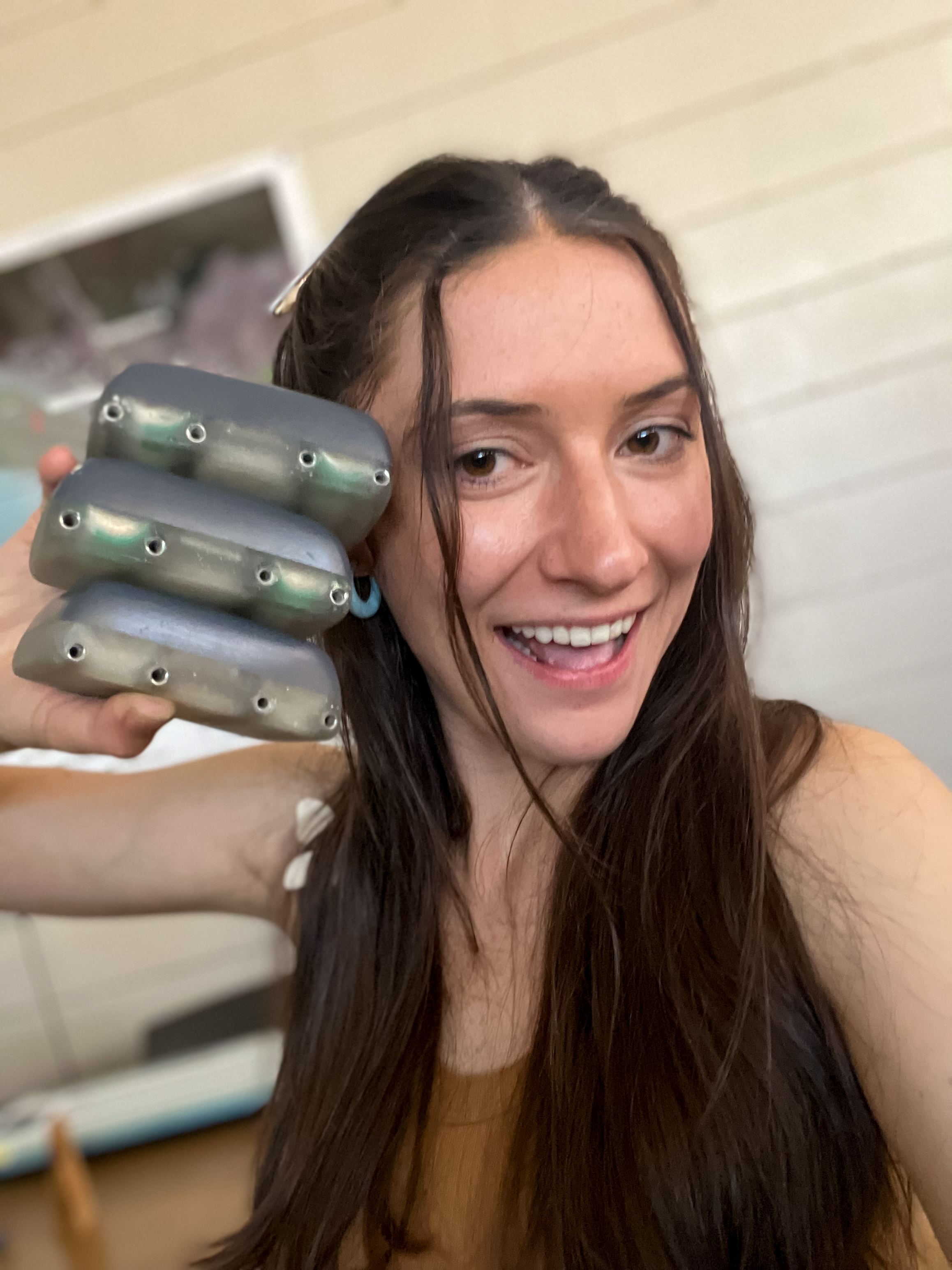
Maggie McGreal contributed to R&D Project - "Crocodilian Monitoring Project"
Maggie McGreal added a new R&D - "Crocodilian Monitoring Project"
Maggie McGreal added a new Discussion - "Seeking advice for remotely retrieving high frequency acceleration data " to Animal Movement
Groups
Group
- Group Stats
-


- 598
- 245
- Latest Discussion
- Apis Nomadica Labs: Mobile Bee-Search for the Future of Food & Medicine
- Latest Resource
- /
- Siguiendo Ballenas: rastreo satelital desde el espacio revela sus rutas migratorias // Tracking right whales from outer space reveals their migratory routes
Un ambicioso proyecto internacional está usando transmisores satelitales para monitorear los viajes migratorios de ballenas francas australes, permitiendo entender sus sorprendentes patrones de desplazamiento en tiempo real. // An ambitious international project is using satellite tags to monitor the migratory journeys of southern right whales, allowing researchers to understand their surprising movement patterns in real time.
Group
- Group Stats
-


- 337
- 33
- Latest Discussion
- DIY: Pressure Chamber
- Latest Resource
- /
- Can CBIs promote coexistence? A Case Study from Northern Tanzania
Can conservation-based incentives promote the willingness of local communities to coexist with wildlife? A case of Burunge Wildlife Management Area, Northern Tanzania
Group
- Group Stats
-


- 442
- 223
- Latest Discussion
- Online Ocean-Focused GIS Course
This is a chance to participate in a short survey about the preferences that conservation practitioners have for evidence. There's a chance to win one of three £20 Mastercard gift cards.
Group
- Group Stats
-


- 436
- 298
- Latest Discussion
- Free online tool to analyze wildlife images
- Latest Resource
- /
- IUCN Red list R client.
Everything you need on the IUCN Red list is now accessible from R, outputted as tibble to facilitate data query, analysis, and visualization.
Group
- Group Stats
-


- 343
- 222
- Latest Resource
- /
- Nature Tech for Biodiversity Sector Map launched!
Conservation International is proud to announce the launch of the Nature Tech for Biodiversity Sector Map, developed in partnership with the Nature Tech Collective!
Group
- Group Stats
-


- 201
- 221
- Latest Discussion
- Support the Cartographer Cause!
- Latest Resource
- /
- MyProgress: Advancing GIS and R programming skills.
A fascinating journey of unleashing my potentials in spatial analysis using ArcGIS Pro and R programming.
Group
- Group Stats
-


- 474
- 162
- Latest Discussion
- Apis Nomadica Labs: Mobile Bee-Search for the Future of Food & Medicine
- Latest Resource
- /
- Zimbabwe Shines: 5 Key Takeaways from Ramsar COP15
Making waves in wetland conservation: Explore the outcomes and insights from Ramsar COP15, a premier global event on wetland protection and sustainability
Group
- Group Stats
-


- 454
- 300
- Latest Discussion
- G-DiNC 2026: Global Drones in Nature Conservation Symposium & Expo
- Latest Resource
- /
- BoutScout – Beyond AI for Images, Detecting Avian Behaviour with Sensors
In this case, you’ll explore how the BoutScout project is improving avian behavioural research through deep learning—without relying on images or video. By combining dataloggers, open-source hardware, and a powerful BiLSTM deep learning model trained on temperature data, the team has reduced the time needed to analyse weeks or even months of incubation behaviour to just seconds. This has enabled the discovery of new patterns in how tropical birds incubate their eggs across different elevations and climates. With tools soon to be released on PyPI, including a no-code platform for behavioural analysis, this work offers a fresh, scalable approach for conservationists and researchers working on breeding data at the tropics.
Group
- Group Stats
-


- 394
- 125
- Latest Resource
- /
- BoutScout – Beyond AI for Images, Detecting Avian Behaviour with Sensors
In this case, you’ll explore how the BoutScout project is improving avian behavioural research through deep learning—without relying on images or video. By combining dataloggers, open-source hardware, and a powerful BiLSTM deep learning model trained on temperature data, the team has reduced the time needed to analyse weeks or even months of incubation behaviour to just seconds. This has enabled the discovery of new patterns in how tropical birds incubate their eggs across different elevations and climates. With tools soon to be released on PyPI, including a no-code platform for behavioural analysis, this work offers a fresh, scalable approach for conservationists and researchers working on breeding data at the tropics.
Group
- Group Stats
-


- 584
- 277
- Latest Discussion
- Free online tool to analyze wildlife images
- Latest Resource
- /
- IUCN Red list R client.
Everything you need on the IUCN Red list is now accessible from R, outputted as tibble to facilitate data query, analysis, and visualization.
Group
- Group Stats
-


- 355
- 151
- Latest Discussion
- G-DiNC 2026: Global Drones in Nature Conservation Symposium & Expo
- Latest Resource
- /
- Siguiendo Ballenas: rastreo satelital desde el espacio revela sus rutas migratorias // Tracking right whales from outer space reveals their migratory routes
Un ambicioso proyecto internacional está usando transmisores satelitales para monitorear los viajes migratorios de ballenas francas australes, permitiendo entender sus sorprendentes patrones de desplazamiento en tiempo real. // An ambitious international project is using satellite tags to monitor the migratory journeys of southern right whales, allowing researchers to understand their surprising movement patterns in real time.
Bookmarks
Keep track of the resources that matter to you! Collections let you save, organise, and share content from all over the WILDLABS community. Create your first collection by clicking on the bookmark icon wherever you see it.
My Courses
These are your in-progress and completed courses. Explore more courses through our catalogue.
To find courses you have created, see your "My Draft Content" or "My Content" tabs.
Settings
Maggie McGreal's Content
Discussion
Does anyone have advice on finding/using commercially available biologgers (or buoy systems) with acoustic sensors for recording sound?We are interested in studying the behavioral...
5 June 2025
Discussion
Does anybody have advice for software or websites that you can simply upload GPS and altitude data to create a 3D animation of an animal's flight path? I'm looking for something...
1 August 2024
Discussion
Hi everyone, it’s time I introduce our project titled “Innovative Sensor Technologies for Sustainable Coexistence: Advancing Crocodilian Conservation and Ecosystem Monitoring...
11 July 2024
Discussion
Hi everyone! I'm currently working with a small team to develop and deploy custom affordable trackers for crocodiles, and I'm wondering if anyone has advice regarding data...
28 January 2024
We are developing and employing multisensor trackers to monitor the movements and behaviors of crocodiles in the wild & generating an acceleration ethogram based on motion data of alligators to develop techniques for the onboard processing of behavior and activity summaries.
Maggie McGreal commented on "WILDLABS AWARDS 2024 - Innovative Sensor Technologies for Sustainable Coexistence: Advancing Crocodilian Conservation and Ecosystem Monitoring in Costa Rica"