Group curators

Talia Speaker
- @TaliaSpeaker
- | She/her
WILDLABS
World Wide Fund for Nature/ World Wildlife Fund (WWF)

Lacey Hughey
- @lhughey
- | she/her
Smithsonian Conservation Biology Institute
Animal movement technologies have already significantly advanced our understanding of the natural world, from uncovering previously mysterious migration patterns and key movement corridors to demonstrating the impacts of anthropogenic pressures and climate change. Continuing advances in the development of technologies for collecting and transmitting bio-logging data, combined with the increased availability of high-resolution environmental data and analytical developments in movement modelling, are opening doors to novel applications. However, there are still major gaps in the space, including mobilizing movement data to translate data from tracking devices into insights for application in policy and practice. This group is a place for the animal movement community to connect and discuss our efforts to advance the field.
Resources for beginners
Learn about WILDLABS Animal Movement research projects
- MoveBON Initiative Announcement
- MoveBON Follow-Up Discussion
- Virtual Meetup Season 4: Tracking Progress (A WILDLABS research project on movement ecology)
Group curators
- @TaliaSpeaker
- | She/her
WILDLABS & World Wide Fund for Nature/ World Wildlife Fund (WWF)
I'm the Executive Manager of WILDLABS at WWF


- 23 Resources
- 64 Discussions
- 31 Groups
- @lhughey
- | she/her
Smithsonian Conservation Biology Institute
I am an ecologist and program manager with experience leading collaborative research projects in international settings. I specialize in the application of animal tracking data to conserve migratory species on a changing planet.


- 6 Resources
- 10 Discussions
- 3 Groups
No showcases have been added to this group yet.

Cellular Tracking Technologies
Biz Dev at Cellular Tracking Technologies


- 5 Resources
- 76 Discussions
- 4 Groups

- @Paladitya
- | He/His
Conservation biologist from Nepal and the founder of the Nature Conservation and Research Committee. He spearheads initiatives like the Bengal Florican Project, Birders of Nepal podcast, Wild Chapter, and The Ornithology, all aimed at advancing grassroots across South Asia.
- 0 Resources
- 1 Discussions
- 5 Groups

- @ahmedjunaid
- | He/His
Zoologist, Ecologist, Herpetologist, Conservation Biologist


- 74 Resources
- 7 Discussions
- 25 Groups


- 0 Resources
- 0 Discussions
- 2 Groups
- @LisaHein
- | She/her
Conservationist with a focus restoration ecology/rewilding and botany, a keen birder and currently working in the Seychelles with giant tortoises


- 0 Resources
- 14 Discussions
- 6 Groups
- @PhilAtkin
- | He/Him
Embedded software developer of 40+ years experience, hardware designer.


- 3 Resources
- 22 Discussions
- 6 Groups
Aquaculture expert and social entrepreneur passionate about fish welfare and conservation. Founder of iCAREFISH, working with African riverine communities to improve wild and farmed fish welfare through innovation, advocacy, and training.
- 0 Resources
- 0 Discussions
- 3 Groups
PhD student
- 0 Resources
- 0 Discussions
- 8 Groups

- @Dauson_M
- | Mr
Dauson Msumange is a social enterpreneur, founder and director of Tanzania Eco-Tech And Conservation Hub (TEACH).
- 0 Resources
- 1 Discussions
- 23 Groups

- @nazarioe11
- | She/Her
University of California Santa Cruz
Graduate student interested in marine predator physiology, biogeography, and conservation.
- 0 Resources
- 0 Discussions
- 4 Groups

- @Freaklabs
- | He/Him
Freaklabs
I'm an engineer and product designer working in conservation technology. I specialize in technology for landscape restoration and wildlife behavioral ecology.

- 1 Resources
- 307 Discussions
- 20 Groups
African Parks
- 0 Resources
- 0 Discussions
- 10 Groups
Careers
Mobile App. Developer / Gibbon Research

Kyle Winney
Can you create an ecological data collection application on Android for Gibbon and Biodiversity Research. Check out this opportunity with us!
24 August 2023
Article
Rewildology Podcast - Wildlife Tracking

Wildlife Drones
An engaging conversation about wildlife drones
21 August 2023
Article
MoveApps: A Digital Home for Tracking Data Analysis

Max Planck Institute of Animal Behavior
In this Conservation Tech Showcase case study from 2022 Conservation Tech Award winner MoveApps, you’ll learn how they’re breaking new ground in animal movement research with tracking data analysis tools hosted by the...
17 August 2023
Careers
Conservation Technology Specialist

Wildlife Conservation Society (WCS)
WCS is seeking a Conservation Technology Specialist to join their work in the Okapi Wildlife Reserve.
11 August 2023
Article
SensorDrop

Lars Holst Hansen
A[n open source] system to remotely detach individual sensors from wildlife tracking collars
11 August 2023
Link
Firetail 11 released - for GPS and sensor analysis

Tobias Petri
I wrote a short article on new features in Firetail 11. The most recent version (11.0.3) features some great performance improvements and also fully enables the new reporting module. see also: https://wildlabs.net/...
10 August 2023
Article
#Tech4Wildlife Photo Challenge: Judges' Panel Honorees

WILDLABS Team
Please join us in celebrating this year’s top #Tech4Wildlife Photo Challenge Honorees as chosen by our panel of leading conservation organization judges, and enjoy the story contained within these entries about how our...
4 August 2023
Article

Join us as we count down the WILDLABS community's honorees in the first-ever #Tech4Wildlife Community Choice Awards!
3 August 2023
Article
"We integrated a Kinetron MSG32 microgenerator and a state-of-the-art lithium-ion capacitor (LIC) into a custom GPS-enabled tracking device that is capable of remotely transmitting data via the Sigfox ‘Internet of...
13 July 2023
Article
ICARUS flies faster, further
Lars Holst Hansen
The tracking system has begun testing its new satellite receiver that will continue uninterrupted tracking of animals from space
13 July 2023
Careers
Postdoc for electrical engineering at NASA
Roland Kays
Spaceborne Satellite-tag RF Systems to Measure Spatiotemporal Patterns of Wildlife
12 July 2023
Article

In this article from Alasdair Davies, he discusses how marine tracking's unique challenges could impact its potential for sustainability in the future.
12 July 2023
August 2025
event

Louisa Richmond-Coggan
September 2025
event
Louisa Richmond-Coggan
event
Louisa Richmond-Coggan
October 2025
event
Lacey Hughey and 3 more
November 2025
event

Brigitta Keeves
February 2025
event
Wildlife Drones
event
Talia Speaker and 1 more
January 2025
event

Talia Speaker and 1 more
event
Wildlife Drones
100 Products
Recently updated products
| Description | Activity | Replies | Groups | Updated |
|---|---|---|---|---|
| Hi everyone,I want to use this platform to spread the word about AfriMove, a collaborative initiative to share movement data collected from... |
|
Animal Movement | 5 months 1 week ago | |
| The application deadline for the AniMove Workshop 2025 in Costa Rica is the 31st of May 2025. Hurry and sign up here |
|
Animal Movement, Conservation Tech Training and Education, Data management and processing tools, Geospatial, Software Development | 2 months 2 weeks ago | |
| Hi Vivian,Thank you so much for your reply! I appreciate the pointers on species mixing, to clarify: I have been experimenting with deer data, but for once the project is underway... |
|
Animal Movement | 2 months 3 weeks ago | |
| Hi Ethan, It's indeed a competitive area. My advice for you (and anybody else seeking a PhD supervisor)...Do background research on each individual potential supervisor and always... |
|
Early Career, AI for Conservation, Animal Movement, Climate Change | 2 months 4 weeks ago | |
| We are please to inform that we have implemented the point 1 and 4 and with this have finalized the project. The latest improvements:Improvement in findability of help... |
|
Animal Movement, Data management and processing tools, Software Development | 3 months ago | |
| Hello everyone!My collaborators and I are trying to assess the extent to which animal movement ecology is currently being integrated into... |
|
Animal Movement | 3 months ago | |
| My name is Frank Short and I am a PhD Candidate at Boston University in Biological Anthropology. I am currently doing fieldwork in Indonesia using machine-learning powered passive... |
|
Acoustics, AI for Conservation, Animal Movement, Data management and processing tools, Early Career, Emerging Tech, Ethics of Conservation Tech, Protected Area Management Tools, Software Development | 3 months 1 week ago | |
| Thanks Phil - I have e-mailed you.Peter |
|
Animal Movement, Sensors | 3 months 2 weeks ago | |
| Hi, we've gotten more than 20 replies until now so thank you if you took the time to answer.And we would really appreciate if you could spare a few minutes to answer if you haven'... |
|
Emerging Tech, Animal Movement, Build Your Own Data Logger Community | 4 months ago | |
| Reopenning this discussion again in case there is some news! |
+25
|
Animal Movement | 4 months 2 weeks ago | |
| Good morning JocelynThank you very much for your comment, this is proving to be very useful advice and thank you so much for setting me on the right path!! This is very exciting!!... |
|
Animal Movement, Citizen Science, Human-Wildlife Coexistence, Marine Conservation, Drones, Community Base, Geospatial | 4 months 3 weeks ago | |
| Hi Nikita, If you haven't already, I'd recommend reaching out to the folks at the Cornell Ornithology lab. They're really glued into all things bird. In particular, I... |
|
Animal Movement, Drones, Emerging Tech, Human-Wildlife Coexistence | 4 months 3 weeks ago |


Webinar: Wildlife Drones’ Dragonfly – Revolutionizing VHF Tracking Technology
3 February 2025 4:31am
The transmission range of animal tracking tags.
16 December 2024 1:13pm
10 January 2025 4:06pm
Hi Chittakon,
I think an 'ideal' optimization between transmission interval and battery life would depend on the application. As I think Peter has indicated, longer transmission intervals could make it very difficult to determine direction, particularly on a moving animal. If you were not trying to find direction and/or locate the transmitter - maybe just detecting presence or absence - then a longer interval could work. cheers
29 January 2025 10:43pm
Choice of pulse interval on VHF transmitters really comes down to how mobile your study animal is and how complex the tracking environment is.
I have used pulse intervals down to 2 seconds on animals that spend a lot of time sitting still. This does save on power but if you are used to a faster pulse interval, it can be a real lesson in patience when you are trying to get an accurate bearing on the transmitter. For animals that are constantly on the move, don't even think about going slower than 1 second, particularly if the transmitter is likely to be intermittently blocked by habitat features.
Other ways of saving power can be to have periods when the transmitter is scheduled to sleep (when you are unlikely to be tracking) or to have bursts of pulses (say 1 minute on, one minute off).
Another important feature to consider is ensuring that the transmission has a stable pulse strength and frequency. There is nothing as frustrating as a transmitter that fluctuates in signal strength.
Collaring Elephants and Post Release Monitoring

28 January 2025 3:16pm
Collaring elephants and post-release monitoring
In Post Release Monitoring (the monitoring of animals after release back into the wild), the invaluable insights that we gain from GPS-enabled collars help us to:

CCTV or camera trap for 24/7 video recording
8 January 2025 12:01pm

11 January 2025 4:30pm
BTW, on this subject. I've developed the 24/7 video recorder part for this now. It works really well. It saves as .mov files that play on all platforms, Linux, Mac and Windows.
13 January 2025 6:21pm
The thermal recordings in this video were recorded with it
24 January 2025 12:34pm
Hi,
I am using these for my current project:
PHILIPS Outdoor Weatherproof WiFi CCTV Camera for Home | Pan Tilt Zoom, Color Night Vision, 2-Way Talk, AES-128bit Encryption| HSP3800 | 360Degree Surveillance (White) : Amazon.in: Electronics
PHILIPS Outdoor Weatherproof WiFi CCTV Camera for Home | Pan Tilt Zoom, Color Night Vision, 2-Way Talk, AES-128bit Encryption| HSP3800 | 360Degree Surveillance (White) : Amazon.in: Electronics

PHILIPS 5000 Series Wi-Fi 360 Degree Camera | AI-Enhanced CCTV Camera for Home & Outdoor | 2K(3MP) Resolution, Privacy Shutter, Pan Tilt Zoom, 2-Way Talk, DIY Installation | HSP5500 : Amazon.in: Home Improvement
PHILIPS 5000 Series Wi-Fi 360 Degree Camera | AI-Enhanced CCTV Camera for Home & Outdoor | 2K(3MP) Resolution, Privacy Shutter, Pan Tilt Zoom, 2-Way Talk, DIY Installation | HSP5500 : Amazon.in: Home Improvement
They seem to be of good quality and support offline SD card storage. These run on 5V/1A. You should be able to run them for about two days on a 45 or 50,000mAh powerbank.
There should be UK versions of these.
However, like all CCTV manufacturers (atleast the ones i checked), downloading the continuous recordings isn't as easy as plugging in the SD card into your computer and copying the files. The video files are deliberately made hard to read. Everything is through their app. You can download events (movement/sound) captured by the cameras though.
WILDLABS Behind the Buzz: Translating Science to Policy
Talia Speaker
and 1 more
22 January 2025 12:35am
Data science/analyst interested in volunteering for research or app development

17 January 2025 5:28am
PhD Position in Movement Ecology of Forest Elephants

15 January 2025 8:43pm
Master Project: Individual Differences in Movement Strategies of Captive-bred and Wild-born North African Houbara Bustards
15 January 2025 10:10am
Thesis Collaboration

4 January 2025 5:15pm

7 January 2025 12:32pm
Hi Simon,
Did you already contact INBO? Both biologging and citizen science are big themes at INBO. Last year we had a master thesis on camera trapping invasive muntjac. You can send me a private message for more info!

14 January 2025 3:30pm
Hi Simon,
We're a biologging start-up based in Antwerp and are definitely open to collaborate if you're interested. We've got some programs going on with local zoo's. Feel free to send me a DM if you'd like to know more.
15 January 2025 8:30am
Hi Simon,
We (Reneco International Wildlife Consultants) have an ongoing collaboration with a local University (Abu Dhabi, UAE) for developing AI tools (cameratrap/drone images and video analyses) and biomimetic robots applied to conservation (e.g https://www.sciencedirect.com/science/article/pii/S1574954124004813 ). We also have a genetic team working on eDNA. Field experience could be possible, in UAE or Morocco.
Feel free to write me back if you may be interested and would like to know more
Webinar: Drone-based VHF tracking for Wildlife Research and Management

9 January 2025 11:45pm
WILDLABS Behind the Buzz: Key Policy Frameworks
Talia Speaker
and 1 more
7 January 2025 11:17pm
Behind the Buzz Season 1: From Data to Decisions
Talia Speaker
and 1 more
7 January 2025 11:15pm
Video evidence for the evaluation of behavioral state predictions
17 December 2024 11:02am
19 December 2024 11:53am
Currently, the main focus is visual footage as we don't render audio data in the same way as we do for acceleration (also: the highly different frequencies can be hard to show sensibly side by side).
But In this sense, yes, the new module features 'quick adjust knobs' for time shifts: you can roll-over a timestamp and use a combination of shift/control and mouse-wheel to adjust the offset of the video by 1/10/60 seconds or simply enter the target timestamp manually down to the millisecond level. This work can then and also be saved in a custom mapping file to continue synchronisation work later on.

19 December 2024 12:59pm
but no "time scaling" adjustments to adjust a too "slow" or too "fast" video ?
19 December 2024 4:07pm
No, not yet. The player we attached does support slower/faster replay up to a certain precision, but I'm not sure that this will be sufficiently precise for the kind of offsets we are talking about. Adding an option on the frontend to adjust this is quite easy, but understanding the impact of this on internal timestamp handling will add a level of complexity that we need to experiment with first.
As you said, for a reliable estimate on this kind of drift we need at least 2 distinct synchronized markers with sufficient distance to each other, e.g. a precise start timestamp and some recognizable point event later on.
I perfectly agree that providing an easy-to-use solution does make perfect sense. We'll definitely see into this.
Firetail 13 - now available
10 December 2024 10:55am

13 December 2024 3:31am
Thank you so much for looking into this issue quickly! Much appreciated.
17 December 2024 10:40am
I promised to keep you updated, and the article is now available here:

17 December 2024 10:42am
and a short contribution in this e-obs setup, where we used Firetail VideoSync to analyze motion-triggered camera footage:

Integrating wildlife tracking with other technologies
7 January 2016 12:21pm

27 June 2016 3:59pm
Hi Paul,
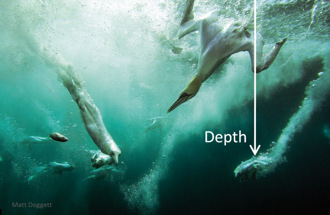
I just remembered another one for the list. @BethClark is taking some really cool environmental readings for seabirds - Gannets - basically to build a picture of their lives in 3D. She talks about it on her blog here.
A few excerpts:
Electronic devices are attached onto the birds to record their behaviour: GPS, altimeters, accelerometers and dive recorders. The key will be to use multiple loggers on the same bird to record their flights in great detail. The GPS tracking project has been going on Grassholm for a few years now and we are building up a good picture of where they tend to forage.
The altimeters show the height above the sea, which gives us 3D tracks of the birds’ movements – very cool! The higher you are, the further you can see, but the more difficult it is to pick up scents from the sea. We will find out if these 3D help us pick out foraging behaviour and see how they actually find fish (and fishing boats) in a huge and seemingly featureless ocean.
Dive recorders show the timing and depth of the famous torpedo plunge dives, which will let us know when the birds have successfully found a fishing ground.
The accelerometers measure acceleration in 3 directions, showing even a single wing flap. This will help us to measure how much effort the bird are putting in when they travel and forage, which is very important for trying to figure out how they decide where to go. We will also be able to identify other behaviours, such as telling apart high-speed plunge diving from a slower dive made from the surface.
I think altimeters and dive recorders might be new ones for your list. Beth's here on WILDLABS.NET (and has promised a nice case study for our Resources area), so I think she'd be delighted to answer any questions you might have.
Cheers,
Steph
16 August 2016 10:37am
Hello again!
An interesting paper exploring the new technologies being used to study cetaceans has a section devoted to what they term high-resolution multisensor tags (page 4).
As with @BethClark 's work above, the questions that arise when studying marine mammals bring another dimension into what information we might require sensors to collect. For example:
Among cetaceans, there are two suborders: Odontocetes (toothed-whales) and Mysticetes (baleen whales). In general, toothed whales and dolphins use high-frequency acoustics for interanimal communication and feeding. In the marine environment, where sight is limited, sound propagates extremely well and all marine mammals communicate primarily through acoustic cues. Similar to bats, toothed whales and dolphins feed via high-frequency sound production known as echolocation, where acoustic signals reflect off of targets and the returning echoes can be translated into information on the environment or potential prey. For many years, independent passive acoustic recorders have been used to study the vocalizations of marine mammals. However, the incorporation of acoustic recorders (hydrophones) into animal-borne tags has only occurred in the past 20 years (Fletcher, Le Boeuf, Costa, Tyack, & Blackwell, 1996). The information that is recorded on the sensors in these tags (e.g. acoustic, movement) can be used to determine the frequency and acoustic structure of vocal behaviours that occur concomitant with motor behaviour, for example, echolocation signals during feeding events (Madsen, De Soto, Arranz, & Johnson, 2013) or contact calling while diving ( Jensen, Marrero Perez, Johnson, Aguilar Soto, & Madsen, 2011). Echolocation ‘clicks’ and ‘buzzes’ have been used from animal-borne tags to study the foraging behaviour of a wide range of odontocetes, from the small harbour porpoise, Phocoena phocoena, to the largest, the sperm whale (Fais et al., 2015; Wisniewska et al., 2015). This information has provided critical data on the feeding depths, frequency, timing and prey types targeted by different species and the behaviours associated with foraging (Johnson, de Soto & Madsen, 2009). These insights into feeding behaviour have recently been used to help determine foraging performance and foraging ecology (Watwood, Miller, Johnson, Madsen, & Tyack, 2006), as well as the energetic consequences of disturbing this behaviour (Miller et al., 2009). These new data products are ripe for linking to conservation efforts such as the individual and population consequences of human activities disrupting these behaviours (e.g. the use of naval sonar and seismic surveys). We explore below the tools produced, as well as new ones in development, to forge these links.
You have already identified sound in your original list, but I think the use of hydrophones with tags is an interesting addition - an example that didn't immediately spring to mind (at least for me), when I thought about the list.
Cheers,
Steph
In Press: Nowacek, D. P., et al., Studying cetacean behaviour: new technological approaches and conservation applications, Animal Behaviour (2016), http://dx.doi.org/10.1016/j.anbehav.2016.07.019

14 December 2024 12:18am
Hi Both of you,
Just a quick note now. Very interesting articles and topics found and discussed here. In my work with biophysical aspects of cheetahs I will review these things you have written. Thank you very much. Followed here from the sidelines
BR Henrik
Human mobility data
13 December 2024 4:09pm
Tracking orangutans

29 October 2024 3:15pm
6 December 2024 12:59pm
Depending on what you really need, you might have different options. I don't think collar/bracelet for great apes is currently resolved reliably, and could pose risks to the animals. Implantable transmitters are one option but more invasive. I think Chris Walzer (currently at WCS) has done some initial work on implanting orangutans (or gibbons), but that was quite some years ago. Others might have done it since as well. FWIW we have implanted captive chimpanzees with subcutaneous transmitters for other reasons and some have removed/damaged it, so that's a risk. Intraabdominal might be another (though even more invasive) option.
Is visual observation an option? This is well used in many species, though might be very costly/labour intensive. I have been involved in a project with howler and spider monkey where this has been used successfully, happy to put you in touch with them.
If your questions is primarily absence/presence of certain individuals, you could also try DNA based methods? And someone suggested below individual ID from video/pictures, this has been done in captive great apes, so it is an option, but you still need to get the shots in the first instance, so probably not many advantages over manual monitoring methods.

10 December 2024 6:46am
Our city-neighbours Robotto are a Drone AI-software company and have an ongoing animal tracking projects in Thailand, Australia, and Greenland (probably more by now) in co-op with WWF, using drones.
Give them a look! I know Kenneth, their CEO, pretty well so can match you two.
A rough explanation of how the tracking process happens is:
A forest ranger brings a suitcase with a drone to a watchpoint, pilots the drone around the area for 30-50 minutes while monitoring detections real-time on the provided screen.
Have seen it live in Thailand, it was impressive! :)

13 December 2024 3:44am
In a recent call with researchers in Thailand. They have mentioned that they use passive chip readers to log data about chipped animals as they pass by.
Looking for advise on a suitable VHF receiver

25 November 2024 7:52pm
2 December 2024 10:13pm
Thanks so much Robin for the contact information. Very useful!
Ravi
3 December 2024 5:35am
Hello @robbiemp
My method may not be the best at the moment, but I’ll share the results from my previous tests. Here’s what I’ve tested: “DIY using SDR connected to a smartphone as a radio telemetry receiver.”
I have a VHF receiver that works with SDR and an Android smartphone. I’ve tested it with a VHF tag that I built myself, "My VHF Telemetry Tag Building Project From Scratch."
It depends on whether you need data or just audio. If you need data, SDR may not perform very well. But if you’re just after audio signals, it can work similarly to a regular VHF receiver. By using a Yagi antenna and connecting the SDR to the smartphone, it can work for any frequency range you want. I used 148-151 MHz, but you can use more than that.
Please understand that it works similarly to a commercial VHF receiver, but it may not be as good as the ones available in the market due to various limitations. However, it can still be used. I tested it with a Yagi antenna that I made myself (but if you already have an antenna, you can use it too), and I was able to detect my VHF tag from a distance of about 1.2 kilometers and 800 meters for the VHF tag I received from @Rob_Appleby . This is just a rough test.
If you need a receiver that can operate across a wide range of frequencies, I think the RTL-SDR would be a good option as well.
This may not be the best method, but it works just fine. Thank you, and if you have any questions, don’t hesitate to ask me.
10 December 2024 10:07am
Thanks so much Chittakon. I have ordered the parts, and will be trying the phone method.
My VHF Telemetry Tag Building Project From Scratch
15 September 2024 2:32pm
14 October 2024 9:12am
Hi, I understand the Notch filter, I confirm there is no hardware modification, and this is the module I am using.I just set the module to work at the frequency I want to use, to test it. I think in real use, you can advise everyone better.
https://www.nicerf.com/fsk-front-end-module/433mhz-rf-module-rf4463pro.html
I only modified the start frequency. You may be able to give a better answer than me. You can access the entire project on my drive.
https://drive.google.com/drive/folders/1jX0e9Ul5pmmnUhKd2L4jNMg8V0WxpFaG?usp=drive_link
28 November 2024 7:20am
@jcturn3 I’ve added the details for creating the tags, and I hope it will be helpful to you.

30 November 2024 11:05pm
Wonderful thank you! I'll look into it shortly.
Recovery Ecology Post Doctoral Associate - San Diego Zoo Wildlife Alliance
26 November 2024 11:47pm
Two Postdoctoral Fellowships on the Spatial Ecology of Bustard Species
11 November 2024 2:45pm
LoRa GPS monitoring
4 November 2024 2:54pm

6 November 2024 11:54am
Hi @ONCA
LoRaWAN can be used very successfully in the applications you have mentioned!
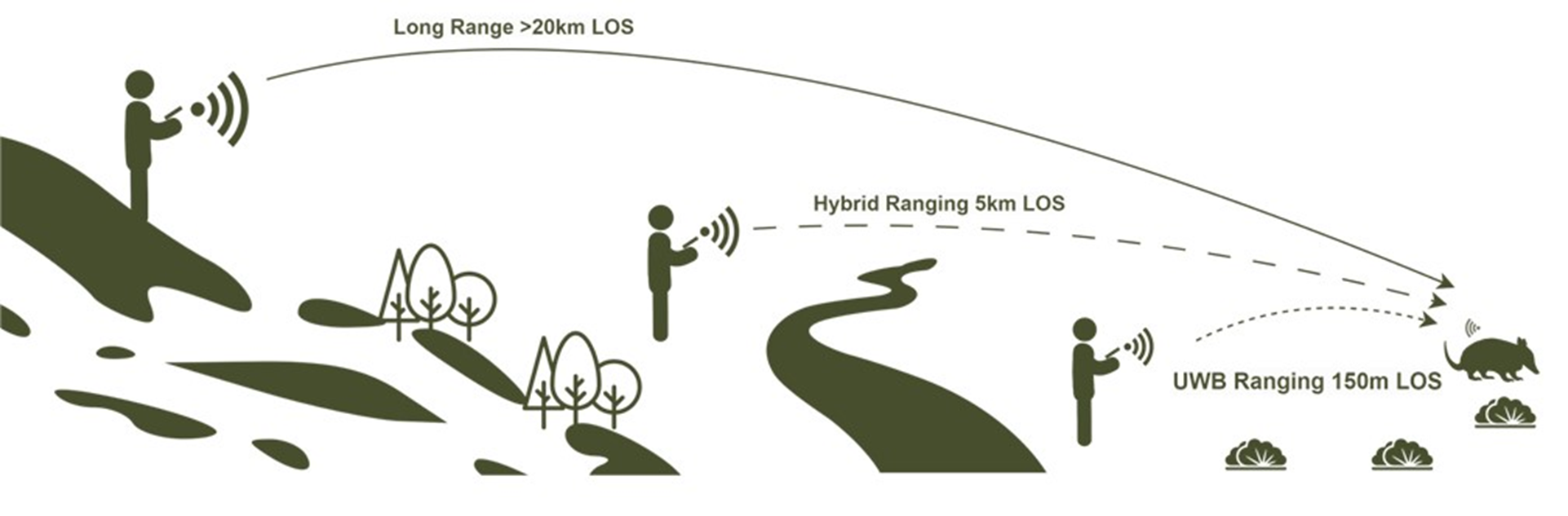
Our TagRanger system is based around LoRaWAN and we've done a lot of range testing in various environments to assess performance.
LoRaWAN has various 'spreading factors' which govern not only potential range, but also how often you can transmit. The lowest (SF7) has the shortest range but you can transmit very often, while the highest (SF12) has the longest range but you are more limited in how often you can transmit.
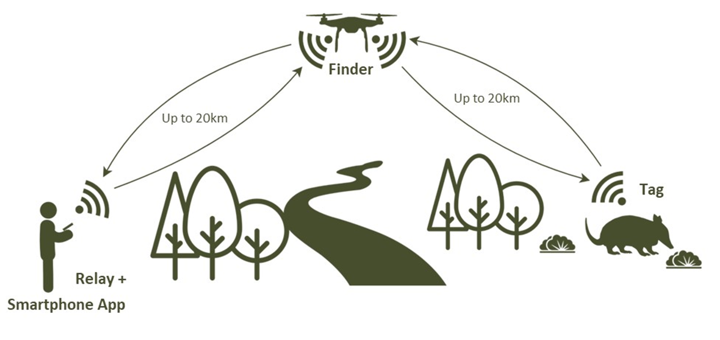
TagRanger can use a fixed LoRaWAN network installation, but we also have a 'Finder' device which acts as a LoRaWAN Gateway and attaches to your phone providing your own mobile LoRaWAN gateway you can pop up anywhere. This gives great mobilty and we've also added special features such as remote Tag wake-up which you don't get with LoRaWAN networks.
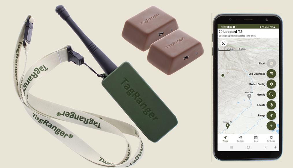
We've tested range using a Finder communicating with our standard Tag which has an integrated antenna in a number of scenarios. We had robust communications at 21km with a line of sight connection at which point we ran out of space! We could see from the LoRaWAN transmit/receive metrics that there was still plenty of headroom left to go even further, estimating >30km. As an aside, we've also had a turtle tracking version of our TagRanger Tag using an external wire antenna communicating at 48km.
We've also tested in a dense pine forest, in the rain (which makes things worse). We made sure the line of sight was through all the trees and could reliably connect over 1km away (before running out of room again) and this was approaching the limit.
Understanding that there are limits to LoRaWAN range, we also provide a 'Relay' capability with our TagRanger system. This allows you to effectively double the range between you and your Tag by putting the Finder on a drone, mast, balloon or strategic mountain top and hopping the connection from the Relay, to the Finder and on to the Tag.
The biggest advantage of using the Relay though, is that you can look down through a canopy (or into a valley) and mitigate issues with signal propagation through a load of trees.
Hope that helps for now, let me know if you would like any further information!
https://www.tagranger.com
Craig

11 November 2024 7:19am
I agree. With clear line of sight you can get really good coverage (High antenna on a hill or building and sensors/antenna within line of sight).
I have worked in Bolivia and the topography, vegetation cover and moving species in your area are very hard to work with. Also I can second @craig with humid forest in the rain reaching it´s max distance at about 1000m. Moving anmials make it much harder. I´m still a big fan of LoRa also beeing amazed by the fast pace of Meshtastic in recent weeks. Im really hoping for more LoRa over satellite solutions. This will hopefully solve lots of these issues.
Greetings from the Austrian (Rain) forest,
Robin

11 November 2024 8:25am
Hi @ONCA ,
Good to know you are looking into this. I have checked our email, but can not find any request for information or contact. Please reach out to me personally at tim@smartparks.org
15km range with any terrestrial wireless connectivity in the forest is not realistic, this has nothing to do with LoRa/LoRaWAN specifics, but with radio in general. The signals will be absorbed by the vegetation. Therefore you need to looks at different strategies then tracking wildlife in the savanna or desert. Bear in mind that also the GNSS (GPS) signals coming from the satellites will have the same issue.
Possible strategies:
- Using Mesh/Relay networks in increase network density
- Using "contact tracing"
- Using LoRaWAN to satellite
- Using downloading of "logs" at fixed locations in the forest
Happy to discuss further.
Building a flexible and detachable Yagi antenna
2 November 2024 9:16am
Can wireless charging technology be used for animal sensors?
17 October 2024 7:03am
23 October 2024 3:43pm
The results in the paper you mentioned are really exciting technology. It can really do a lot of things.
Thanks for your reply!
23 October 2024 4:00pm
Although this technology may not be mature now, and there are still many problems to be discussed and solved, I think it will have good application prospects.
Unfortunately, I am just an undergraduate student in China, and what I can do is very limited. Maybe in the future I can also do some similar research or what I want to do. Just like you, I am studying hard now.
Thank you very much for this forum and the professionals who responded to me. You have allowed me to see more perspectives and many things I didn't realize. Thank you very much!
28 October 2024 3:13pm
No problem at all Yu (@JY) and good luck with your studies! Happy to discuss this and any other ideas any time.
All the best,
Rob
COP16 Event: Harnessing Animal Movement Data to Meet Biodiversity Goals
21 October 2024 6:14pm
Roe deer protection needed in Hungary, national government should stop funding hunting organizations - call for international support

7 October 2024 11:58am
14 October 2024 12:41pm
Really? Can you share where its written.
Annex III: protected fauna species, do you need a glass?
14 October 2024 1:33pm
A quick search comes up with the following answer. Let us know if that helps.
Annex III of the European Environmental Agency (EEA) does not directly regulate the protection or hunting of specific species. Instead, it's important to look at Annexes II and IVof the EU Habitats Directive (Directive 92/43/EEC) for species protection and hunting regulations in the European Union.
Roe deer (Capreolus capreolus) is not listed in Annex IV (which covers strictly protected species), meaning it is not afforded the strictest protection that prevents all forms of exploitation. However, Annex III of the Bern Convention, which relates to species that may be exploited but require careful regulation, includes species like roe deer.
In many European countries, roe deer hunting is permitted under specific regulated conditions. These regulations aim to ensure sustainable hunting practices and maintain healthy population levels, with hunting seasons and quotas determined based on local wildlife management policies.
In summary, roe deer are generally not strictly protected across the EU, and hunting is allowed under regulation, though specific conditions depend on national and regional legislation.
Disclaimer: I can't guarantee that the above is not a hallucination :-)
15 October 2024 11:24am
Thanks, we know they are breeding these animals here, I asked, since it's seems to be an expensive hobby, we need to allocate more funding for rural women in entrepreneurship and access to technologies, reduce poverty in Hungary No1 priority.
That's the problem local peoples can not afford buying wild meat from the "local shop"
Fully uncontrolled activites in Hungary
MS and PhD Opportunities in Ocean Engineering and Oceanography

6 October 2024 9:44am
Calling for applications for Round 3 of our Satellites for Biodiversity Award Grant
30 September 2024 5:22pm
EarthRanger and Skylight for improving protected and conserved area effectiveness
23 September 2024 1:30pm
10 January 2025 1:41pm
There was research on this in the very early days of VHF radio tracking. I presume what you are interested in is the period between audible bleeps vs the easeof detecting a mximum as an antenna is rotated to get a directional fix. If memory serves the optimum between battery life and ease of use was either an interval of 0.8s or a frequency of 0.8 Hz (so an interval of 1.2 s). The low end of your adjustment range would be midway between those two - the res tof the range would be very hard to use.