Animal movement technologies have already significantly advanced our understanding of the natural world, from uncovering previously mysterious migration patterns and key movement corridors to demonstrating the impacts of anthropogenic pressures and climate change. Continuing advances in the development of technologies for collecting and transmitting bio-logging data, combined with the increased availability of high-resolution environmental data and analytical developments in movement modelling, are opening doors to novel applications. However, there are still major gaps in the space, including mobilizing movement data to translate data from tracking devices into insights for application in policy and practice. This group is a place for the animal movement community to connect and discuss our efforts to advance the field.
Resources for beginners
Learn about WILDLABS Animal Movement research projects
- MoveBON Initiative Announcement
- MoveBON Follow-Up Discussion
- Virtual Meetup Season 4: Tracking Progress (A WILDLABS research project on movement ecology)
Group curators
- @TaliaSpeaker
- | She/her
WILDLABS & World Wide Fund for Nature/ World Wildlife Fund (WWF)
I'm the Executive Manager of WILDLABS at WWF



- 23 Resources
- 64 Discussions
- 31 Groups
- @lhughey
- | she/her
Smithsonian Conservation Biology Institute
I am an ecologist and program manager with experience leading collaborative research projects in international settings. I specialize in the application of animal tracking data to conserve migratory species on a changing planet.


- 6 Resources
- 10 Discussions
- 3 Groups
No showcases have been added to this group yet.
Field-based ecological engineer and naturalist with a special interest in data science and a strong passion for innovation in biodiversity monitoring.
- 0 Resources
- 2 Discussions
- 6 Groups
Machine learning & data science specialist. Passionate about oceans, data and impact.
- 0 Resources
- 4 Discussions
- 5 Groups
Conservationist | Ecologist| Geospatial Scientist
- 0 Resources
- 1 Discussions
- 12 Groups
Movement ecologist using conservation technology to study the behaviors of animals in the wild to understand how they cope with change and most effectively address conservation- and conflict-related issues.


- 0 Resources
- 10 Discussions
- 11 Groups
- @tobiaspetri
- | he/him
Schäuffelhut Berger GmbH
data science & algorithmic development for movement ecology


- 11 Resources
- 33 Discussions
- 10 Groups
I'm a PhD student at UW working with the Smithsonian and Center for One Health Research. I develop models to predict and explain zoonotic disease patterns, with a strong emphasis on how these diseases impact wildlife populations and communities sharing the same landscape.


- 0 Resources
- 13 Discussions
- 12 Groups
Forester/ Ecologist with a Master’s Degree in the department of Range science - Wildlife and Fresh water fisheries.
- 0 Resources
- 0 Discussions
- 11 Groups
- @Ilenia
- | She/her
I'm a PhD student focusing on communication in canids. I'm interested in animals' social behavior and cognition.
- 0 Resources
- 2 Discussions
- 5 Groups
- @Pooja_Lama
- | She/Her
I am an early career researcher who is interested in contributing to wildlife conservation.
- 0 Resources
- 0 Discussions
- 9 Groups
- 0 Resources
- 0 Discussions
- 8 Groups
- @MandyEyrich
- | She/Her
University of Florida (UF)
Bridging industries with 15+ years of cross-sector expertise specializing in user-centric technology and product strategy, UX research, UX/UI design, process optimization, and end-to-end agile product development moving from ideation to iteration.
- 0 Resources
- 0 Discussions
- 26 Groups
- @lhughey
- | she/her
Smithsonian Conservation Biology Institute
I am an ecologist and program manager with experience leading collaborative research projects in international settings. I specialize in the application of animal tracking data to conserve migratory species on a changing planet.


- 6 Resources
- 10 Discussions
- 3 Groups
Un ambicioso proyecto internacional está usando transmisores satelitales para monitorear los viajes migratorios de ballenas francas australes, permitiendo entender sus sorprendentes patrones de desplazamiento en tiempo...
7 August 2025
If you're a Post-Doctoral Fellow, a PhD student, or a member of the research staff interested in applying your computational skills to support active research publications, please read on to learn about the Cross-...
5 August 2025
Each quarter, Holohil will be supporting projects by donating up to CAD$2,500.00 toward the purchase of Holohil transmitters. We will also pay all shipping charges (Note: importation duties and taxes are the receiver’s...
4 August 2025
The Marine Innovation Lab for Leading-edge Oceanography develops hardware and software to expand the ocean observing network and for the sustainable management of natural resources. For Fall 2026, we are actively...
24 July 2025
Link
Firetail now features a fresh account over at Bluesky - follow us for updates on animal tracking, bio-logging and, of course, upcoming releases and features!
26 June 2025
Hi together, I am working on detecting causalities between land surface dynamics and animal movement by using satellite-based earth observation data. As this is might be your expertise I kindly ask for your support...
8 May 2025
A Post-Doc position is available to join the team coordinating the Urban Exploration Project – a collaborative initiative in partnership between the University of St. Andrews and the National Geographic Society.
2 May 2025
The Convention on the Conservation of Migratory Species (CMS) is seeking information on existing databases relevant for animal movement. If you know of a database that should be included, please complete the survey to...
30 April 2025
We are hiring for a customer support / marketing specialist.
20 February 2025
We look for a person with programming skills in R and/or Python.
4 February 2025
Are you interested in developing new 3D motion capture techniques to for measuring super fast wildlife like cheetahs? Are you interested in working with fusing exciting technologies such as event cameras, audio and...
3 February 2025
This leads to an exciting blog we did recently, it also includes a spatial map indicating elephant movement tracks of an orphaned elephant who self released himself into the wild (Kafue National Park). Cartography was...
28 January 2025
August 2025
event
September 2025
event
event
October 2025
event
November 2025
event
October 2024
event
event
100 Products
Recently updated products
| Description | Activity | Replies | Groups | Updated |
|---|---|---|---|---|
| Thanks Adrien, I have reached out to Rob |
|
Animal Movement | 9 hours 11 minutes ago | |
| Hi thereI am working with a small dendrobatid amphibian population living in tree tops in Panama, less than 30 mm SVL, and I want to... |
|
Animal Movement | 2 days 4 hours ago | |
| 🐝 Apis Nomadica Labs: Mapping Royal Jelly Terroir Through Mobile Bee BiotechAbout Us:Apis Nomadica Labs is a mobile apiary research... |
|
Acoustics, Conservation Tech Training and Education, Animal Movement, Human-Wildlife Coexistence | 1 week 1 day ago | |
| You could just throw out that data, but I think you'd be doing yourself a disservice and missing out on some interesting insights. Are you training the AI with just pre-COVID... |
|
AI for Conservation, Animal Movement, Data management and processing tools, Human-Wildlife Coexistence | 1 week 6 days ago | |
| Wonderful video! Really impressive :) |
|
Animal Movement, Human-Wildlife Coexistence, Latin America Community | 6 months 1 week ago | |
| Thank you. A couple of things I've done in getting a completely different GPS logging system running.I do use a local clock to keep local time when the GPS is off. ... |
|
Animal Movement | 2 weeks 4 days ago | |
| Thanks @Adrien_Pajot, we are! Also buoys! |
|
Acoustics, Animal Movement | 1 month 1 week ago | |
| I create ocean exploration and marine life content on YouTube, whether it be recording nautilus on BRUVs, swimming with endangered bowmouth... |
|
Acoustics, AI for Conservation, Animal Movement, Camera Traps, Citizen Science, Drones, Emerging Tech, Marine Conservation, Sensors, Sustainable Fishing Challenges, Wildlife Crime | 1 month 2 weeks ago | |
| Hi Craig, I have had the chance to look more closely into your TagRanger product and the information that is available also here on WildLabs. I would definitely be interested... |
+10
|
Animal Movement | 1 month 2 weeks ago | |
| Thank you for your reply, ChadI meant 10 as a whole, indeed. Perhaps you see your post in one group, but since it is tagged for all groups, I assumed you meant 10 in total.In your... |
|
Acoustics, AI for Conservation, Animal Movement, Camera Traps, Citizen Science, Climate Change, Community Base, Connectivity, Drones, eDNA & Genomics, Emerging Tech, Funding and Finance, Geospatial, Human-Wildlife Coexistence, Software Development, Wildlife Crime | 1 month 3 weeks ago | |
| Thanks Fadhilla! I met with your colleague Henrick at the booth. :-) |
|
AI for Conservation, Animal Movement, Camera Traps, Citizen Science, Community Base, Data management and processing tools, Early Career, Geospatial | 1 month 3 weeks ago | |
| Hi everyone,I am working in a national park where a local NGO is soon to be setting up a LoRaWan gateway mainly for monitoring animal... |
|
Animal Movement | 2 months 1 week ago |
WILDLABS AWARDS 2024 - Underwater Passive Acoustic Monitoring (UPAM) for threatened Andean water frogs
30 March 2024 3:54pm
7 April 2024 6:09pm
This is so cool @Mauricio_Akmentins - congrats and look forward to seeing your project evolve!
1 May 2024 5:17pm
Congratulations! My first hydromoth was just arrived yesterday and so excited! Looking forward for the update from your project!!!
The Inventory User Guide
1 May 2024 12:46pm
Introducing The Inventory!
1 May 2024 12:46pm
22 July 2024 10:55am
23 July 2024 2:05pm
23 July 2024 2:53pm
Program Manager: Integrating movement and camera trap data with international conservation policy
22 April 2024 10:16pm
Postdoc: Biologging & Camera Trap Data Integration
22 April 2024 10:10pm
Waterproofing DIY VHF transmitter
27 March 2024 8:57am
21 April 2024 9:27am
That's my kinda crazy @Rob_Appleby. Reminds my of a concept from my last job where they were trying to create strain gauge power meters that customers could self apply to their bikes. Normally this process was done in factory using special CA glue cured in 50-90c ovens. For the self applying version they were experimenting with an adhesive that had tiny metal beads in it that would heat up when a current was applied to self cure if I remember correctly.
22 April 2024 2:44pm
Now I want to be able to drop it from a drone and have it glue itself to the fur of a deer or wild hog. I am designing that now, it will have a detachable lawn dart that drops from a drone and lands on a target animal. That lawn dart delivers the payload, either a tracker or a dose of contraceptives. Then the drone comes and picks up the lawn dart again for reloading.
So the lawn dart has a small compressed air cylinder and some pneumatic style switches. When it touches down the switch actuates and the compressed air energy is used to deliver a dose of drugs and or spray some glue and ink. That can be reloaded with a bike pump and hypodermic.
22 April 2024 2:51pm
I am working on that too haha. So in my design you load the glue gun with two part Loctite, it has two separate metal rings. Glue and hardener in each ring. Then each ring has a few tiny holes drilled, and you fill the holes with a disposable plug.
When the switch is actuated the pressure inside the metals rings goes from atm to 100kPa, and sprays the glue and hardener together as the plugs blow out. The transmitter is attached to the plugs, so it is left behind and glued in place with one switch. That loctite glue is basically instant. The whole thing would not even be that traumatic to the animal. When you score a hit, you find the lawn dart glue gun again and pick it up with the drone.
TagRanger: Redefining animal tracking iwth ad-hoc wireless networks and software-defined technology
17 April 2024 11:22am
Lotek Telemetry Talks Presents: Tagging Owls – Tips & Tricks from the Experts
16 April 2024 8:26pm
WILDLABS AWARDS 2024 - TimeLord: A low-cost, low-power and low-difficulty timer board to control battery-powered devices
5 April 2024 3:29pm
16 April 2024 9:34am
Thanks @Freaklabs, I think you'll really enjoy getting involved with this too as we're looking for input from makers in the community to get the most from the approach and to capture features and usability ideas from a large number of people.
I've a new modular drop-off tag build using @Rob_Appleby's original SensorDrop board that I think would be great for this project too to see if we can drop different compartments, or do various different timed events with the one TimeLord board.
Most importantly, we have to make it play a MIDI version of the DoctorWho theme song when you arm the device. That has to be the #1 feature if you ask me!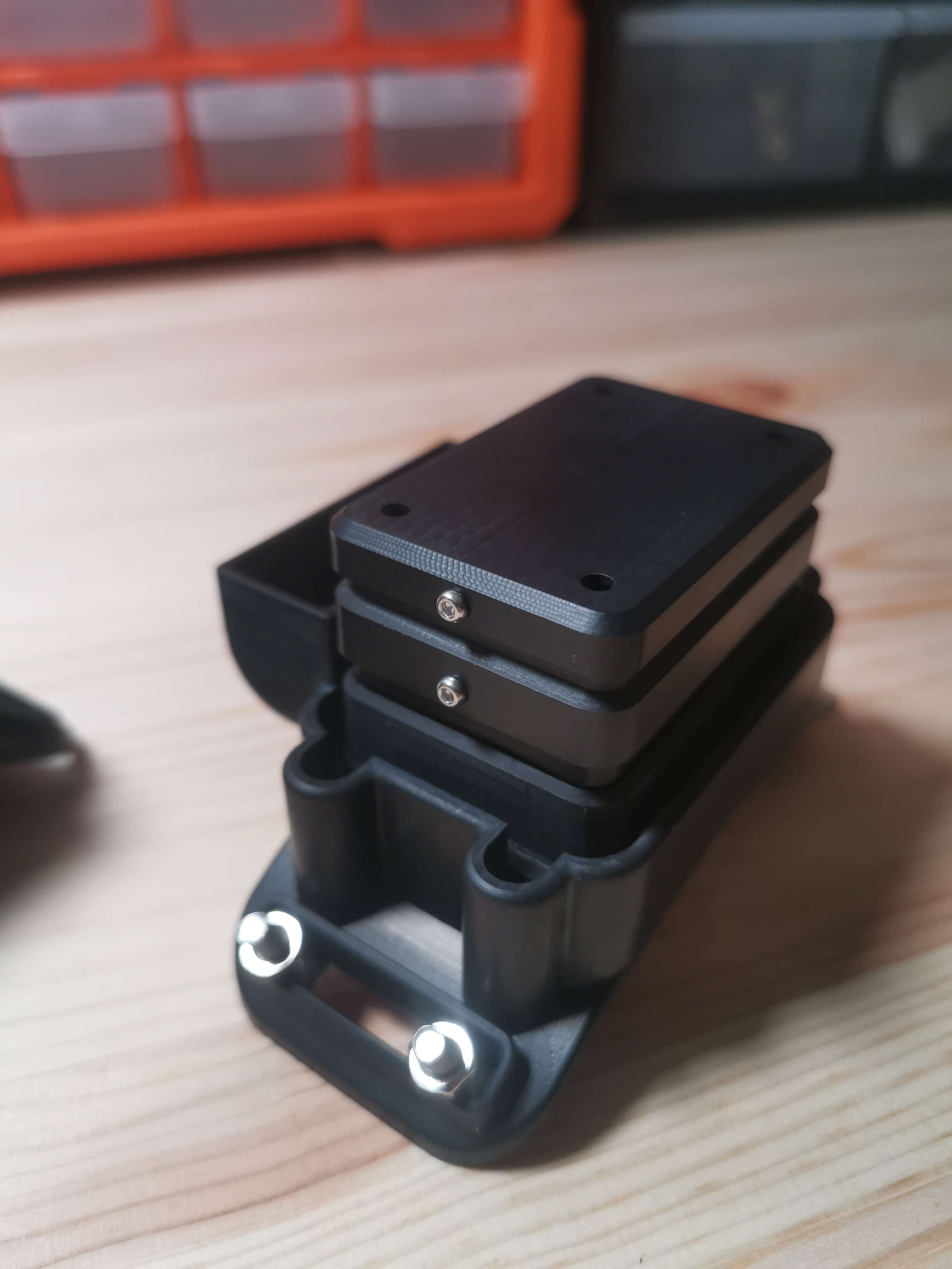
16 April 2024 9:35am
Reminds me that we should look at both terrestrial and marine applications when we get stuck in to the demo builds to make sure we cover use cases
16 April 2024 10:22am
'Most importantly, we have to make it play a MIDI version of the DoctorWho theme song when you arm the device. That has to be the #1 feature if you ask me!'
Seconded!
DIY VHF receivers?
12 March 2024 2:51pm
29 March 2024 4:32pm
Hi Brandon,
I agree and think VHF will always have better range than UHF. Given how commonly it's used in wildlife tracking, it also makes perfect sense to use it if possible. The trade-off for us was to go for lower cost and higher availability parts. This is particularly a problem for VHF receivers, as you mentioned in your original message. But, SDR is good option potentially for VHF (and UHF), especially given the success of MOTUS.
Range of our 433MHz UHF tags was usually around 250m (up to 500m) LOS, using an external antenna and a high transmission power. We also used high gain, omnidriectional antennas on the receiver end. Tags were triggered by an accelerometer threshold so that they'd save a bit of power whilst animals were resting.
More than happy to discuss further and help if I can.
Cheers,
Rob
3 April 2024 5:04am
Hi Brandon,
This is hard for me to write, because I don't have good news for you. You can find many receivers and transmitters for 433MHz that are used for remote control, such as wireless doorbells, garage door openers, lost model locators, etc. These are extremely cheap, a couple of dollars literally. While this tech can be modified to operate with wildlife tags (around 150MHz), we are talking about hacking RF, not to be approached lightly.
If you really need to DIY, I see 2 options: migrate to 433MHz and build/rebuild all your kit (tags, collars, receivers, locators). Commercial solutions are cheap and available, the work remaining is not much above handyman level. But it is work, and not just work but also testing.
The other option is to remain with 150MHz (although you can make your own tags) and modify an aviation receiver (it lets you listen in to aircraft talking to each other or to the airport). These receivers operate at 130MHz, which puts it in spitting range of 150MHz wildlife tags (this matters). This is the option I'd go for, just because I know it can be done, and I have less sense than curiosity.
4 April 2024 9:05pm
You mention you're working with an engineer, here are a couple of pointers:
- with an SDR (the "digital USB receivers" you mention) you can scan some bandwidth to detect radio pulses. I'm only familiar with the Lotek coded VHF transmitters but they can be received as in the Motus Sensorgnomes. I can point you at the code used there, it does involve a good amount of digital signal filtering/analysis code. One issue with the SDRs is that they're pretty power hungry so you need to plan on more solar panel and battery than you may like, e.g. even rPi Zero + SDR is probably >300mA. Another issue can be interference in that SDRs have a very wideband front-end and so TV, radio, and other stuff can desensitize the front-end.
- there are integrated receivers (ICs) that can be tuned to 150Mhz and can detect VHF transmissions, it's easy for non-coded ones, a bit more involved for coded ones. Specifically, the Semtech sx1231 or sx1276 series are widely available (often called Hope RF69 or RF96, which are modules with those chips). You need someone comfortable writing a customized driver that uses OOK mode or RSSI detection. The other issue is that while there are many suitable boards available for 433/868/915Mhz (e.g. Adafruit, Sparkfun, LilyGo, and many others) you most likely won't find one for 150Mhz. However, for RX-only the matching isn't so super important if you have a good antenna and the signal isn't crazy weak. From a power point of view these can sip power so you can run one on an 18650 for days and a small 1W-5W solar panel is most likely all you need.
Hope this helps...
How does behavior influence the use of technology for animal detection ?
22 March 2024 7:49pm
The Variety Hour: 2024 Lineup
22 March 2024 4:30pm
extending battery life with solar panels
27 February 2019 7:47am
12 January 2023 1:56pm
Hi Peter, we manufacture solar powered Iridium trackers for birds, crocs/alligators and collars for various species. Our longest standing unit is a 55g unit on a Vulture and has been going for 4 years, providing data on an hourly basis. Our croc units include a pressure/depth sensor and provide details of depth and time at depth. Most of our devices include a VHF transmitter which is fully configurable over the air (you can change frequency, pulse duration, pulse interval and operation times - good for security).
12 January 2023 3:08pm
Hi Greg! Your Iridium tags sounds really interesting. I tried looking you up on
but there is not much to be found. Can you provide more details and images of your tags?
Cheers, Lars
22 March 2024 3:12pm
Hello Peter,
Have you find a solution ? I will be happy to discuss with you about your project and field challenges ?
Best,
Virginie
Catch up with The Variety Hour: March 2024
21 March 2024 7:39pm
21 March 2024 9:48pm
30 March 2024 3:08pm
31 March 2024 12:43pm
Leveraging Actuarial Skills for Conservation Impact
15 March 2024 12:31pm
19 March 2024 6:35pm
Thank you for your response Akiba. I will have a look. 👏🏻
19 March 2024 7:52pm
I would look into the TNFD (Taskforce on Nature-Related Disclosures), Finance for Biodiversity, Accounting for Nature, etc. which are all focusing on how to incorporate nature risk into corporate reporting and sustainability frameworks!
20 March 2024 3:48pm
Thank you Carly, I will definitely take a look.
Senior Post-doctoral Researcher/Senior Research Associate Opportunity: Movement ecology of Greenland halibut
13 March 2024 2:00pm
IMU and orientation data for marine species
13 March 2024 9:12am
Here's what you missed at World Wildlife Day 2024
7 March 2024 9:02pm
15 March 2024 2:42pm
Need tips on best practices tracking turtles
4 March 2024 12:52pm
6 March 2024 1:24pm
Hi Gabriel,
Our TagRanger Tags can be used for tracking turtles, we already have a tracking project commencing soon in South America for ~40 turtles...
https://www.tagranger.com/
The Tags use LoRaWAN allowing you to communicate with your Tags in real time. As well as requesting current GPS locations from long distances away (20km Line of Sight) you can also use the integrated ranging tools which give you distance to your Tag in metres when you get closer.
Key features:
LoRaWAN (tested > 20km line of sight). Use a 'Finder' which is a handheld gateway or you can also use your own LoRaWAN network.
UWB ranging gives distance (in metres) to the Tag up to 150m away
Hybrid Ranging combines the equivalent of a VHF pinger from a few km away (line of sight) with the UWB ranging when you get closer
Log Download remotely using UWB radio
The Tag can last for very long lifetimes depending on how you configure it
Please drop me a line if you are interested in hearing more about this and how we could configure it best for your application.
Craig
Firetail - updated price model from 03/2024
4 March 2024 11:06am
Data Logger Suggestions
31 January 2024 1:42pm
10 February 2024 2:19am
Hi Andrea,
The OpenLog Artemis might be an option. I haven't used one of these yet, but its what I immediately thought of. Built in real time clock and IMU that records to microSD. It has four 14-bit ADCs and I2C connectors for the 'Qwiic' or 'grove' sensor boards. I'm not sure if it has programmable on/off cycles with the clock but you may find an existing project that does this.
SparkFun OpenLog Artemis - SparkFun Electronics
We have stock of a new OpenLog Artemis (without IMU) available now! Notice: Supply chain constraints have made the on-board ICM-20948 IMU very difficult to source. That said, we have a new version of the OpenLog Artemis available now with the IMU re
13 February 2024 4:29pm
Thank you for the help!
Seeking doctoral student to Join Move.inFormation research group for Andean condor biologging
12 February 2024 8:01pm
Wildlife Drones will be hosting in-person demos in the U.S.
12 February 2024 3:32am
Seeking advice for remotely retrieving high frequency acceleration data
28 January 2024 1:26am
28 January 2024 9:42am
Hi Maggie!
This sounds like a really interesting - and challenging project!
UHF is used for tranfer of acceleration data (along with other stuff like magnetometry and GNSS locations) by systems developed by companies like Milsar and TechnoSmart.
Ceres Wild uses satellite transfer over the GlobalStar but no raw acceleration data is transmitted.
I would fear the bandwidth would be too restrictive if you insist in using satellite based transfer of accelerometry.
Cheers,
Lars
29 January 2024 5:19pm
This sounds like a lot of fun!
The lowest cost satellite comm I know of is https://swarm.space/. It's pretty cool tech, but the data rates are quite low.
Do you have any idea how much data you need to move per day on average?
Perhaps LoRa would be an option? Here is an example of a LoRa device https://www.adafruit.com/product/4284
LoRa is not satellite, but it has quite a long range which may suffice? It is also pretty low data rate, but it is a good deal better than Swarm. The best thing about LoRa is that the end-point can be very low power, so battery life can be quite good.
If you know somewhere the crocs frequent, you might also be able to work something out with Bluetooth LE? Both LoRa and Bluetooth would require the installation of at least one base station. Lora's base station could be substantially further way.
11 February 2024 2:33am
I have a few suggestions Maggie. Hopefully one or more will be useful.
Preprocessing - Compressing the data before transmission will reduce file size and reduce transmission time.
Reduce data volume - I guess the animals are only active for some periods and a lot of the time are just "cruising along". So a useful strategy could be to only start recording when a certain threshold of acceleration occurs. And if you also buffer the data for say 10 seconds, you will get info about what's leading up to the activity. And adding a GPS module you will get some info on where the activity occurred plus movements prior. This will of course increase the data volume but only recording the most recent location will probably suffice as the location of the previous activity will tell you how far the animal moved.
Use LoRa instead of satellite - LoRa is well suited to this type of application. I saw in
that the home range of crocodiles is relatively small so although a forested area will limit LoRa performance, the range should be sufficient. You could also use multiple base stations if needed.
Of course eventually the data that has been recorded at the LoRa base station(s) will need to be collected. You could add a long range radio to the base station, or just collect the data 'manually'.
Hope this helps
PhD position: Foraging in the landscape of peril
10 February 2024 7:27am
Post-doc possition - Field spanning movement ecology, ecology of fear, bio-logging science, behavioral ecology, and ecological statistics
10 February 2024 7:20am
Bio-Logging Science Symposium
9 February 2024 3:59pm
Conservation Technology Intern - The Wildlife Restoration Foundation
8 February 2024 7:52pm
Passionate engineer offering funding and tech solutions pro-bono.
23 January 2024 12:06pm
26 January 2024 3:18pm
Hi Krasi! Greetings from Brazil!
That's a cool journey you've started! Congratulations. And I felt like theSearchLife resonates with the work I'm involved round here. In a nutshell, I live at the heart of the largest remaining of Atlantic forest in the planet - one of the most biodiverse biomes that exist. The subregion where I live is named after and bathed by the "Rio Sagrado" (Sacred River), a magnificent water body with a very rich cultural significance to the region (it has served as a safe zone for fleeing slaves). Well, the river and the entire bioregion is currently under the threat of a truly devastating railroad project which, to say the least is planned to cut through over 100 water springs!
In face of that the local community (myself included) has been mobilizing to raise awareness of the issue and hopefully stop this madness (fueled by strong international forces). One of the ways we've been fighting this is through the seeking of the recognition of the sacred river as an entity of legal rights, who can manifest itself in court, against such threats. And to illustrate what this would look like, I've been developing this AI (LLM) powered avatar for the river, which could maybe serve as its human-relatable voice. An existing prototype of such avatar is available here. It has been fine-tuned with over 20 scientific papers on the Sacred River watershed.
And right now myself and other are mobilizing to manifest the conditions/resources to develop a next version of the avatar, which would include remote sensing capacities so the avatar is directly connected to the river and can possibly write full scientific reports on its physical properties (i.e. water quality) and the surrounding biodiversity. In fact, myself and 3 other members of the WildLabs community have just applied to the WildLabs Grant program in order to accomplish that. Hopefully the results are positive.
Finally, it's worth mentioning that our mobilization around providing an expression medium for the river has been multimodal, including the creation of a shortfilm based on theatrical mobilizations we did during a fest dedicated to the river and its surrounding more-than-human communities. You can check that out here:
Let's chat if any of that catches your interest!
Cheers!
2 February 2024 1:22pm
Hi Danilo. you seem very passionate about this initiative which is a good start.
It is an interesting coincidence that I am starting another project for the coral reefs in the Philipines which also requires water analytics so I can probably work on both projects at the same time.
Let's that have a call and discuss, will send you a pm with my contact details
There is a tech glitch and I don't get email notifications from here.




















5 April 2024 12:13pm
Congratulations, very exciting! Keep us updated!