Group curators

Vance Russell
3point.xyz

Ahmed Junaid
- @ahmedjunaid
- | He/His

Elsa Carla De Grandi
Fauna & Flora
Who We Are
Geospatial data and analysis is critical for conservation, from planning to implementation and measuring success. Every day, mapping and spatial analysis are aiding conservation decisions, protected areas designation, habitat management on reserves and monitoring of wildlife populations, to name but a few examples. The Geospatial group focuses on all aspects of this field, from field surveys to remote sensing and data development/analysis to GIS systems.
How to Get Started
Want to learn more about how remote sensing is used in conservation? Check out the first two episodes of this season of Tech Tutors, where our Tutors answer the questions How do I use open source remote sensing data to monitor fishing? and How do I access and visualise open source remote sensing data in Google Earth Engine? You can also check out our Virtual Meetup Archive for a range of panels that overlap with Geospatial topics, or take a look at our Earth Observation 101 lecture series from Dr. Cristian Rossi.
Our Purpose
The WILDLABS Geospatial Group is for conservation practitioners, geospatial analysts, and academics that want to:
- Share geospatial resources, best practices, data, and ideas;
- Network amongst geospatial and data practitioners;
- Create peer learning opportunities;
- Promote the use of free and open-source geospatial software; and
- Improve the use of GIS software and geospatial analyses in conservation management and research.
Group curators
3point.xyz
Over 35 years of experience in biodiversity conservation worldwide, largely focused on forests, rewilding and conservation technology. I run my own business assisting nonprofits and agencies in the conservation community


- 7 Resources
- 69 Discussions
- 12 Groups
- @ahmedjunaid
- | He/His
Zoologist, Ecologist, Herpetologist, Conservation Biologist


- 75 Resources
- 7 Discussions
- 16 Groups
Fauna & Flora
Remote Sensing Scientist, Conservation Technology & Nature Markets @ Fauna & Flora - WILDLABS Geospatial Group Co-Lead

- 42 Resources
- 49 Discussions
- 9 Groups
No showcases have been added to this group yet.

- 1 Resources
- 0 Discussions
- 1 Groups
- 0 Resources
- 0 Discussions
- 16 Groups

Cambridge based freelance geographer working on geospatial projects in conservation and humanitarian response, locally and globally.
- 0 Resources
- 1 Discussions
- 2 Groups
I am a dedicated professional with a bachelor of science in Wildlife management. I have extensive experience working in research as a Research Assistant and currently serve as a Human-Wildlife Conflict Mitigation Supervisor.


- 0 Resources
- 4 Discussions
- 5 Groups

GIS Developer
- 0 Resources
- 0 Discussions
- 2 Groups

- @Gathoni
- | Her/she
PhD Candidate at Nottingham Trent University, UK. Ecologist with a passion for wildlife conservation and conservation technology with foundational training in BSc and MSc Rangeland Management (Ecology option). Current project: Use of acoustics to monitor ecosystem restoration.
- 5 Resources
- 8 Discussions
- 8 Groups
Biologiste
- 0 Resources
- 0 Discussions
- 12 Groups
- @parlaynu
- | he/him
software engineer
- 0 Resources
- 0 Discussions
- 13 Groups

- 0 Resources
- 0 Discussions
- 11 Groups
- @miasjien
- | she/her
University of Canterbury & University of Pretoria
Marine predator ecologist using biologging, remote sensing to understand species movements and the effects on populations. Mainly working in the Southern Ocean and Antarctic currently.
- 0 Resources
- 0 Discussions
- 9 Groups

Senior web developer and ML practitioner
- 0 Resources
- 0 Discussions
- 6 Groups

Greenhood Nepal
- 0 Resources
- 0 Discussions
- 5 Groups
Article
Icarus Starts First Global Research Project

Max Planck Institute of Animal Behavior
We've got exciting news from the Icarus project, a satellite-based animal monitoring system: following a successful test phase this year, the first cross-continental scientific pilot project is set to begin this...
15 September 2020
Funding
Argos Satellite Tag Open-Source Grant

Thomas Gray
WILDLABS community member Thomas Gray from Argos has given us a preview of an upcoming grant program to develop open-source tags. Three years ago, Argos worked with the Arribada Initiative to develop an open-source...
17 August 2020
Article
Sustainable Fishing Challenges: Fishing Vessels of the Future

Daniel Steadman
As we launch our new Sustainable Fishing Challenges group in the WILDLABS community, we are excited to welcome Daniel Steadman, the group manager, to give us an overview of three major areas in which #tech4wildlife...
4 August 2020
Article
Era of the Condor: A Species' Future in Recovery

Ellie Warren
In this three-part WILDLABS feature article, we'll take a look at the various technologies used to fight the greatest threat to endangered condors, explore the innovations that may change the way we study and understand...
5 May 2020
Article
Talking Tracking with Xerius
Ellie Warren
How does tracking technology meet the many challenges specific to monitoring birds within their home ranges and over long distances during migration? WILDLABS community member Virginie Perilhon from Xerius Tracking...
23 April 2020
Article
WILDLABS Tech Hub: WWF PandaSat

WILDLABS Team
At the 2018 London Illegal Wildlife Trade Conference, we announced the WILDLABS Tech Hub, an accelerator programme created to support the development and scaling of groundbreaking technological solutions addressing the ...
13 April 2020
Community Announcement
WILDLABS Community Call Recording: Rainforest X-PRIZE

WILDLABS Admin
Our second WILDLABS Community Call took place on April 1st to continue the discussion started by Ben Tregenna in our Data Science group, in which he suggested the idea of submitting a collaborative entry to the X-Prize...
30 March 2020
Funding
Competition: Plastic Data Challenge

Ellie Warren
Are you ready for the Plastic Data Challenge? This global contest wants your innovative ideas for improving the plastic waste management and recycling chain in South and Southeast Asia. Participants can consider...
3 March 2020
Article
Instant Detect 2.0 emerges

Sam Seccombe
In the past six months Instant Detect 2.0 has physically emerged, with the first prototype systems built and ready for testing at the start of April. The ZSL team is now well into their optimisation and hardening phase...
3 September 2019
Funding
ESA Kickstarter: Environmental Crimes

European Space Agency (ESA)
The European Space Agency’s “Environmental Crimes” thematic call offers support and funding of up to €60,000 per activity to companies looking to develop services tackling illegal water, air and land polution using...
22 August 2019
Article
The WILDLABS TECH HUB is supporting technology solutions tackling the illegal wildlife trade, in collaboration with the Foreign & Commonwealth Office, Digital Catapult, Satellite Applications Catapult, Amazon Web...
4 June 2019
Article
Meet the WILDLABS TECH HUB Winners
WILDLABS Team
In February, we released an open call for the WILDLABS TECH HUB, offering 3 months of support for solutions using technolgy to tackle the illegal wildlife trade. We were overwhelmed by an incredible 37 submissions,...
13 May 2019
September 2025
event

Ideal Workplace Solutions
October 2025
event

Lacey Hughey and 3 more
November 2025

event

Brigitta Keeves
March 2026

November 2023
event

Stephanie O'Donnell
event

Cassie Anderson

131 Products
Recently updated products
| Description | Activity | Replies | Groups | Updated |
|---|---|---|---|---|
| Support the Cartographer Cause! Hi there,I am on a mission to empower children and communities through maps, GIS — helping people better... |
|
Climate Change, Community Base, Conservation Tech Training and Education, East Africa Community, Geospatial | 2 months ago | |
| Thank you for your reply, ChadI meant 10 as a whole, indeed. Perhaps you see your post in one group, but since it is tagged for all groups, I assumed you meant 10 in total.In your... |
|
Acoustics, AI for Conservation, Animal Movement, Camera Traps, Citizen Science, Climate Change, Community Base, Connectivity, Drones, eDNA & Genomics, Emerging Tech, Funding and Finance, Geospatial, Human-Wildlife Coexistence, Software Development, Wildlife Crime | 2 months 1 week ago | |
| Thanks Fadhilla! I met with your colleague Henrick at the booth. :-) |
|
AI for Conservation, Animal Movement, Camera Traps, Citizen Science, Community Base, Data Management & Mobilisation, Early Career, Geospatial | 2 months 1 week ago | |
| Thank you for your comment Chris! Using these tools has made a huge difference in the way we can monitor and manage Invasive Alien Vegetation. I hope you are able to integrate... |
|
AI for Conservation, Citizen Science, Conservation Tech Training and Education, Drones, Geospatial, Human-Wildlife Coexistence, Open Source Solutions | 2 months 1 week ago | |
| that's really useful! thanks for flagging that :) |
|
Geospatial | 2 months 1 week ago | |
| Hi Geospatial Group, I'd love to hear if anyone has been using the HLSS30: HLS Sentinel-2 Multi-spectral Instrument Surface... |
|
Geospatial | 2 months 2 weeks ago | |
| p.s. https://environmentjob.co.uk/jobs has internships searchable for any location, not just UK. |
|
Geospatial, Early Career, Marine Conservation | 2 months 4 weeks ago | |
| Hi @iainmcnicol , welcome to WILDLABS! Thanks for posting this on here. I have shared with my colleagues at Fauna & Flora who have some experience (especially with the... |
|
Community Base, Geospatial, Protected Area Management Tools, Wildlife Crime | 4 months 2 weeks ago | |
| The application deadline for the AniMove Workshop 2025 in Costa Rica is the 31st of May 2025. Hurry and sign up here |
|
Animal Movement, Conservation Tech Training and Education, Data Management & Mobilisation, Geospatial, Software Development | 3 months ago | |
| Hi all! I recently did a little case study using RGB drone data and machine learning to quantify plant health in strawberries. I wanted to... |
|
Citizen Science, Conservation Tech Training and Education, Drones, Geospatial | 3 months 2 weeks ago | |
| I have posted about this in a different group, but I love boosting the impact of my communication through use of visuals. Free graphics relating to conservation technology... |
|
Geospatial, Climate Change, Community Base, Connectivity, Funding and Finance, Open Source Solutions | 4 months ago | |
| One of our goals with explorer.land is to bridge satellite data and on-the-ground perspectives — helping teams combine field updates,... |
|
AI for Conservation, Geospatial, Open Source Solutions, Sensors | 4 months 1 week ago |


Is anyone using off-the-shelf GIS data collection apps? e.g. Collector for ArcGIS
8 March 2018 5:11pm
28 March 2018 12:40pm
Hi Steve,
Over on Twitter, @RLong has a suggestion that might be useful?
Dave Moskowitz https://t.co/ZJhAPTgzyx has developed some @ESRI Collector workflows for his work with @ConservationNW. You might get in touch with one of them for advice.
— Robert Long (@RLongEco) March 28, 2018
James Bevan also has some feedback:
I’ve used iGIS quite a bit to map points, lines and polygons. Created shapefiles can be emailed or stored in Dropbox and transferred to ArcGIS. The paid version also can calculate area and distance. Cons: somewhat fiddly to use.
— James Bevan (@JamesRBevan) April 9, 2018
Cheers
Steph

24 August 2018 5:18pm
Hi Steve,
I have used GIS Pro by Garafa on an iPad. I found it was one of the only apps that allowed importing of custom raster images. This feature has allowed me to take an image into the field, and ditize on it directly. I am mapping individual trees in airborne remote sensing data, so accurate digitizatoin with reference to my specific image is a must.
Other useful features are that you can create and edit vectors (points, lines, and polygons) and you cache basemaps (Google, Bing...) to work offline.
Happy to talk more about my application and experience with this app.
- Sarah
Spacewalk for ICARUS
24 August 2018 12:00am
How to share data on species to help conserve them… whilst avoiding them being exploited by poachers
20 August 2018 12:00am
Ocean Hack: San Francisco, 10-11th September, 2018
 One Ocean Collab
20 August 2018 12:00am
$90K in grants from the Con X Tech Prize
11 June 2018 12:00am
Webinar: Artificial Intelligence for Earth, Microsoft Research
 Eye on Earth Alliance
23 April 2018 12:00am
Conservation Technology User Guidelines Issue 4: Satellite remote sensing for conservation
23 April 2018 12:00am
#Tech4Wildlife Photo Challenge 2018: Our Top 10
3 March 2018 12:00am
Landsense Innovation Challenge
19 February 2018 12:00am
Technology Empowered Conservation Lecture Series

18 January 2018 12:00am
ESA Space Hack: 17-19th Nov (Helsinki)
30 October 2017 10:20am
Download New Conservation Tech Guidelines: Camera Traps, Acoustics and LiDAR
11 October 2017 12:00am
Learning and Training Resources for GIS - contributions welcome!

19 June 2017 3:09pm
19 June 2017 3:11pm
I wrote an article on Conservation Careers earlier this year on 13 Short Online Course Ideas to Boost Your GIS Career. I'm thinking of adding to this article with some additional courses that have come up recently, or creating a 'sequel' article. If people wanted to contribute then I'd be happy to cite individuals or the WILDLABS Community.
19 June 2017 3:17pm
Thanks for starting this thread, @Thomas+Starnes !
I posted the following twitter conversation in the original Remote Sensing resources thread, yet I think it's possibly more applicable to this thread so am resharing it to make sure it's easily accessible for anyone else looking for GIS specific info in the future.
Does anyone know of good, free resources for learning to use GIS software? (preferably QGIS) #movementecology
— Stuart Watson (@SkipsAhoi) April 24, 2017
My former uni had a subscription to the QGIS Lynda course which was immensely helpful... may be worth checking https://t.co/sDywDX8Y5b
— Arjun Dheer (@ArjDheer) April 24, 2017
Our gentle intro to #GIS should get you started https://t.co/O87TJiz2zy
— QGIS (@qgis) April 24, 2017
There are some great links here: https://t.co/0T2gHoZ0We. Youtube also has excellent tutorials: https://t.co/x8IkUVqc8O. #mapping #gis #qgis pic.twitter.com/JysA4Din63
— WAAS International (@WAASInt) April 27, 2017
— Gerry Ryan (@silverlangur) June 19, 2017
9 October 2017 12:11pm
Hi all,
I just wanted to draw your attention to the new OS Geo UK Training page. This is a really helpful list of GIS training courses on offer in the UK. Anyone can contribute to the list via GitHub.
Thom
Alternatives to shapefiles
11 September 2017 1:34pm
13 September 2017 5:17pm
This is a very good question, @spritchard, and not one specific to the conservation community. I'd suggest maybe also posting on GIS StackExchange? The shapefile has come to be the standard vector exchange format, but you're right that it's actually proprietary. I guess geoJSON is the open source equivalent and it is actually supported in some Esri applications e.g. ArcGIS Server and ArcGIS Online.
19 September 2017 8:04pm
Geopackage and geoJSON for general GIS purpose (the fisrt is particularly optimal for storage and sharing) and sf (stands for simple feature) for R environment spatial data manipulation.

4 October 2017 9:34am
I don't think there is an open like for like replacement. I normally work with ESRI software so mainly use Geodatabases now.
Open options are really in the web format realm (GeoJson) or database (PostGIS, SQLLite, SpatialLite. Also there is KML
DAS: A Scaleable Solution For Protected Area Management
26 September 2017 12:00am
Funding Opportunity: Leverage space technology for wildlife protection
6 July 2017 12:55pm
Funding Opportunity: Leverage space technology for wildlife protection
6 July 2017 12:52pm
Learning and Training Resources for Remote Sensing - contributions welcome!
23 May 2017 11:55am
19 June 2017 2:37pm
I was just thinking along those lines. Yes, whatever you think would be the best structure for collating learning resources.
19 June 2017 2:50pm
We've had similar threads in other groups collating/crowd sourcing info - e.g. recommendations for gear like turtle satellite tags, GSM camera traps or tablets for field research, likewise for collecting a list of citizen science apps, and creating a respository of the different projects using deep learning. @jprobert works really hard to keep our formal resources area updated, but having a live thread as well draws one of the biggests benefits of having this community by enabling everyone to contribute.
Long story short, I think it's a good idea - if you get it started I'll share any resources I come across :)
6 July 2017 9:45am
Satellite Image Analysis and Terrain Modelling – A practical manual for natural resource management, disaster risk and development planning using free geospatial data and software.
This new manual is available to access as a PDF from https://sagatutorials.wordpress.com/training-manual/.
Leverage Space Technology for Wildlife Protection with the European Space Agency Kick-start Grant
5 July 2017 12:00am
International Society for Photogrammetry and Remote Sensing - Student Consortium Newsletter
24 June 2017 2:19am
Apply now for the 2017 Annual Geo for Good User Summit
15 June 2017 7:20pm
16 June 2017 10:14am
Fantastic opportunity - thanks for sharing, @dave !
The Google Earth Engine User Summit 2017 was convened this week also at Google in CA. I know that @andyarnell went and I'm hoping that he will feed back to the group.
CCF GIS Group Social
11 April 2017 9:02am
24 April 2017 10:35am
The next social is on Thursday 27th - same details as above. Hope to see you there!
CCF GIS Group Social
11 April 2017 8:50am
QGIS UK Midlands & East User Group meeting
20 March 2017 9:57am
11 April 2017 8:44am
This meeting will now be followed by the Missing Maps May Mapathon - Cambridge from 18:00 - 20:30, which will also be hosted at the British Antarctic Survey. We also plan to squeeze in a post-mapping drink at The Punter just down the road. Open source GIS followed by humanitarian mapping, followed by free pizza and a pint - what more could you ask for!?
Missing Maps May Mapathon - Cambridge
11 April 2017 8:38am
Missing Maps April Mapathon - Cambridge
21 March 2017 7:30pm
6 April 2017 12:07pm
Hi Steph,
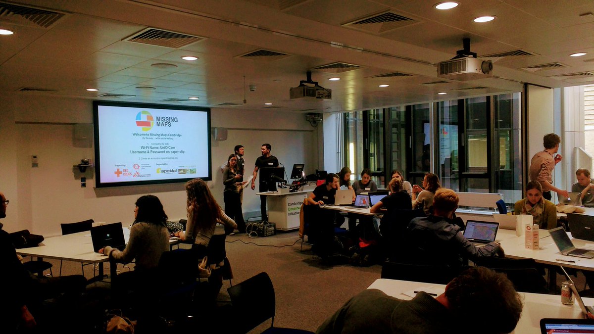
It was fantastic! We had a full house, with all 40 tickets sold out and really good attendance rate. We were mapping an area of Zimbabwe for the Clinton Health Access Initiative's malaria program. We were joined remotely by some collaborators at OpenStreetMap Bangladesh, and together we completed > 70% of the task. The next Cambridge Missing Maps is going to be at the British Antarctic Survey on Thursday 18th May and you can register here! We hope to include the David Attenborough Building on the Missing Maps Cambridge circuit for future events. The Cambridge Conservation Forum GIS Group are also planning to hold a MapforEnvironment event in the very near future, which will of course be advertised on WILDLABS.NET!
Thanks!
6 April 2017 2:11pm
Sounds awesome! Will you be working to finish the other 30% at the next meeting, or working on a new project?
Adding in a great photo you posted from the event on Twitter last night :)
11 April 2017 8:33am
Thanks for adding the photo from the event. Missing Maps is becoming really popular, so tasks get completed quite quickly. We shared the task numbers for people to finish off at home if they wanted to, but by the time of next month's mapping party, this task will long have been completed so we'll be working on another one! I hope you can make it on Thursday 18th May.
Lasers in the Jungle Somewhere: How Airborne LiDAR Reveals the Structure of Forests
 Phil Wilkes
4 April 2017 12:00am
lidar imagery
6 March 2017 11:53am
7 March 2017 11:11am
Hi Paul,
So you have had the good fortune to make this ask during our annual #Tech4Wildlife photo challenge, but unfortunately you've been foiled on this ask (unlike the acoustic and camera trapping photos) - we've yet to see any lidar images shared in the photo challenge. So I'll add a request on top of your request.. if you do have some lidar images that you are willing to share with Paul, please add them to the #tech4wildlife photo challenge mix over on Twitter as well!
To participate this year, all you need to do is:
- Take a photo of how you are using tech to save wildlife
- Share it on Twitter: tell us a bit about your work and the tech featured
- Remember to use the hashtag #Tech4Wildlife and tag us at @WILDLABSNET
Cheers,
Steph
31 March 2017 10:19am
Hi @P.Glover.Kapfer
Have you looked at the Environment Agency LiDAR data available under the Open Government Licence and available from http://environment.data.gov.uk/ds/survey/index.jsp#/survey?
It might also just be worth asking Amphibian and Reptile Conservation whether their LiDAR data are available. They have a 2 ppm coverage of the New Forest National Park from 2015 which is shared with Natural England (contact Arne Loth). The New Forest National Park Authority also have a 4 ppm dataset from a few years previous, though I'm not sure what the copyright status is with that one (contact Lawrence Shaw).
As a fairly frequent LiDAR user, I'd be interested to know more about your best practice guidelines and website.
Thom
Welcome to the GIS group!
16 March 2017 5:59pm

30 March 2017 4:25pm
Hello. I'm working at Korea National Park Service, GISP, and a charter member of OSGeo Foundation. I'm teaching various open source GIS applications such as QGIS, GRASS GIS, Orfeo ToolBox, OpenDroneMap. Nice to know this GIS group!

30 March 2017 5:47pm
Hello, I am currently using QGIS for assessing conservation planning effectiveness and identifying gaps in networks of protected areas in the Neotropics. It's really nice to be able to share and gather knowledge about GIS functionalities.
31 March 2017 12:52am
Hi, I'm a GIS consultant to conservation and research groups, mostly using ArcGIS and, increasingly, QGIS. Lately I've been doing a lot of work with satellite imagery. I've done quite bit of Python programming as well. I hope to meet like-minded folks for information-sharing and maybe even collaboration.
RGS Geo-technologies for field research workshops
21 March 2017 7:54pm

29 March 2017 4:42pm
Thanks for sharing. It looks as though they've recently been cancelled.
29 March 2017 4:59pm
Ah - a shame they've been cancelled, thanks for that update Joel. As an advanced GIS user yourself (you work in GIS with Vulcan, right?), would the higher-level course Thom's looking into organising be of interest?
29 March 2017 6:13pm
Thanks for the update, @joelm . I wonder why they were cancelled - lack of uptake or something else? I'll see what I can find out.
14 March 2018 11:28pm
So Collector is really for editing data, or adding GIS info in the field in a map interface. Works offline. It's ok for that purpose, you can take your entire map, basemap offline to the field, you can see what data has been collected in real-time, but can be buggy and if you accidentelly log out you're completely out of luck with no connection.
I use it to track drone flights - i.e. I flew here, with some notes.
Survey123 is ESRI's solution for ODK or form based surveys. I like it a lot, it's flexible, you don't need people to log in and it just looks better than ODK and works on iOS, and doesn't require the annoying server set-up of ODK and has great offline capability. But it's form-based, you don't really see the data you are editing in a map. But the best part are the analysis features where you can see stats on responses and such.
Let me know if you have more questions, we have used survey123 extensively, also in places where people have limited cell network, and limited knowledge of smartphones.