Group curators

Vance Russell

Ahmed Junaid
- @ahmedjunaid
- | He/His

Elsa Carla De Grandi
Fauna & Flora
Who We Are
Geospatial data and analysis is critical for conservation, from planning to implementation and measuring success. Every day, mapping and spatial analysis are aiding conservation decisions, protected areas designation, habitat management on reserves and monitoring of wildlife populations, to name but a few examples. The Geospatial group focuses on all aspects of this field, from field surveys to remote sensing and data development/analysis to GIS systems.
How to Get Started
Want to learn more about how remote sensing is used in conservation? Check out the first two episodes of this season of Tech Tutors, where our Tutors answer the questions How do I use open source remote sensing data to monitor fishing? and How do I access and visualise open source remote sensing data in Google Earth Engine? You can also check out our Virtual Meetup Archive for a range of panels that overlap with Geospatial topics, or take a look at our Earth Observation 101 lecture series from Dr. Cristian Rossi.
Our Purpose
The WILDLABS Geospatial Group is for conservation practitioners, geospatial analysts, and academics that want to:
- Share geospatial resources, best practices, data, and ideas;
- Network amongst geospatial and data practitioners;
- Create peer learning opportunities;
- Promote the use of free and open-source geospatial software; and
- Improve the use of GIS software and geospatial analyses in conservation management and research.
Group curators

Over 35 years of experience in biodiversity conservation worldwide, largely focused on forests, rewilding and conservation technology. I run my own business assisting nonprofits and agencies in the conservation community


- 5 Resources
- 62 Discussions
- 12 Groups
- @ahmedjunaid
- | He/His
Zoologist, Ecologist, Herpetologist, Conservation Biologist


- 63 Resources
- 7 Discussions
- 26 Groups

Fauna & Flora
Remote Sensing Scientist, Conservation Technology & Nature Markets @ Fauna & Flora - WILDLABS Geospatial Group Co-Lead

- 34 Resources
- 28 Discussions
- 8 Groups
University of Salford
- 0 Resources
- 2 Discussions
- 6 Groups

Neuroscientist & engineer looking for a data/R&D role in conservation.
- 0 Resources
- 0 Discussions
- 17 Groups

An Environmental sciences and Management graduate from SUA, passionate and eager to drive change to the Environment, making World a better place for present and future generations.


- 4 Resources
- 35 Discussions
- 14 Groups
- @hyodopenguin
- | she/her
I am currently a rising junior at UC Berkeley studying data science. I hope to apply data with biodiversity, especially by utilizing camera traps for species classification. People in conservation tech are truly living my dream careers, and I can't wait to get even more inspired!

- 0 Resources
- 5 Discussions
- 23 Groups
Mobile developer w/ a passion for nature and conservation

- 0 Resources
- 16 Discussions
- 6 Groups
- 0 Resources
- 0 Discussions
- 12 Groups

- @TMonteiro
- | she/her
- 0 Resources
- 0 Discussions
- 4 Groups
- 0 Resources
- 4 Discussions
- 7 Groups
- @Mishamo
- | Musa
Am Musa Mishamo the Founder of Rada 360 Ltd based in Dar es salaam Tanzani. Rada is providing satellite based applications in Precision Agriculture, Earth Observation,Navigation and Satellite based Education.
- 0 Resources
- 0 Discussions
- 1 Groups
- 0 Resources
- 0 Discussions
- 9 Groups
- @EvelyneNgugi
- | she/her
Environmentalist and AI Tutor
- 0 Resources
- 0 Discussions
- 12 Groups
- @tsmstrat
- | she/her
- 1 Resources
- 2 Discussions
- 4 Groups
Link
FLORITY

Elsa Carla De Grandi
A precise GPS Field App allowing capture of GPS-Photos and GPS-Polygons, powered by Wells for Zoë. The main goal of the App is to enable low-skilled users to capture highly accurate GPS-Data, via an easy sharing process.
21 February 2025
Link
Saving Peatlands, Securing Our Climate Future
Elsa Carla De Grandi
Excellent StoryMap by WCS illustrating results from a recent paper https://conbio.onlinelibrary.wiley.com/doi/10.1111/conl.13080. Main findings: analysis revealed that 17% of peatlands are protected globally—...
21 February 2025
Link

Interesting package?
18 February 2025
Link
An interesting review?
18 February 2025
Funding

Osa Conservation is launching our inaugural cohort of the ‘Susan Wojcicki Research Fellowship’ for 2025, worth up to $15,000 per awardee (award value dependent on project length and number of awards given each year)....
10 February 2025
Link

https://doi.org/10.3390/rs16030583
3 February 2025
Link
rmacrostrat (R Package).
3 February 2025
climetrics (R package).
3 February 2025
Link
https://www.nature.com/articles/s41559-023-02220-8
3 February 2025
Careers
Rewilding Affric Highlands – GIS and Data Officer

Theresa Stratmann
Seeking an experienced GIS and Data Officer to oversee geospatial data collection, analysis, and management
31 January 2025
Link
https://doi.org/10.1111/nph.20405
29 January 2025
June 2025

event

Joel Masselink
October 2025
event

Lacey Hughey and 3 more
November 2025

December 2023
event
Lucas Mwaura
November 2023
event

Stephanie O'Donnell
event

Cassie Anderson
126 Products
Recently updated products
| Description | Activity | Replies | Groups | Updated |
|---|---|---|---|---|
| The loss of the free NICFI tropics data has been a huge loss for us at CI. We have many teams that were using it for lots of different use cases. If anyone has alternatives, we... |
|
Geospatial | 4 days 13 hours ago | |
| Hi all! I recently did a little case study using RGB drone data and machine learning to quantify plant health in strawberries. I wanted to... |
|
Citizen Science, Conservation Tech Training and Education, Drones, Geospatial | 1 week 1 day ago | |
| I have posted about this in a different group, but I love boosting the impact of my communication through use of visuals. Free graphics relating to conservation technology... |
|
Geospatial, Climate Change, Community Base, Connectivity, Funding and Finance, Open Source Solutions | 3 weeks 3 days ago | |
| One of our goals with explorer.land is to bridge satellite data and on-the-ground perspectives — helping teams combine field updates,... |
|
AI for Conservation, Geospatial, Open Source Solutions, Sensors | 1 month ago | |
| 15 years ago I had to rebuild the dams on a game reserve I was managing due to flood damage and neglect. How I wished there was an easier,... |
|
Drones, Conservation Tech Training and Education, Data management and processing tools, Emerging Tech, Geospatial, Open Source Solutions | 1 month 1 week ago | |
| Hi @iainmcnicol , welcome to WILDLABS! Thanks for posting this on here. I have shared with my colleagues at Fauna & Flora who have some experience (especially with the... |
|
Community Base, Geospatial, Protected Area Management Tools, Wildlife Crime | 1 month 1 week ago | |
| A nice work from @dmorris! See his LK post. "Lots of information in the conservation literature is represented in maps (e.g., the... |
|
AI for Conservation, Geospatial | 1 month 2 weeks ago | |
| Yep see you on friday |
+3
|
Geospatial, Acoustics, AI for Conservation, Camera Traps, Citizen Science, Community Base, Data management and processing tools, Emerging Tech, Open Source Solutions, Protected Area Management Tools | 1 month 3 weeks ago | |
| Yep we are working on it 1/ segment 2/remote unwanted ecosytem3/get local potential habitat4/generate5/add to picture |
|
Geospatial, AI for Conservation, Data management and processing tools, Open Source Solutions, Software Development | 1 month 3 weeks ago | |
| All sound, would be nice if there were only 5, though! |
|
AI for Conservation, Citizen Science, Data management and processing tools, Emerging Tech, Ethics of Conservation Tech, Funding and Finance, Geospatial, Open Source Solutions, Software Development | 1 month 4 weeks ago | |
| Good morning JocelynThank you very much for your comment, this is proving to be very useful advice and thank you so much for setting me on the right path!! This is very exciting!!... |
|
Animal Movement, Citizen Science, Human-Wildlife Conflict, Marine Conservation, Drones, Community Base, Geospatial | 1 month 4 weeks ago | |
| Means so much. Thank you, @CathyNj. |
|
Geospatial | 1 month 4 weeks ago |


Funding Opportunity: Leverage space technology for wildlife protection

6 July 2017 12:55pm
Funding Opportunity: Leverage space technology for wildlife protection
6 July 2017 12:52pm
Learning and Training Resources for Remote Sensing - contributions welcome!

23 May 2017 11:55am

19 June 2017 2:50pm
We've had similar threads in other groups collating/crowd sourcing info - e.g. recommendations for gear like turtle satellite tags, GSM camera traps or tablets for field research, likewise for collecting a list of citizen science apps, and creating a respository of the different projects using deep learning. @jprobert works really hard to keep our formal resources area updated, but having a live thread as well draws one of the biggests benefits of having this community by enabling everyone to contribute.
Long story short, I think it's a good idea - if you get it started I'll share any resources I come across :)

6 July 2017 9:45am
Satellite Image Analysis and Terrain Modelling – A practical manual for natural resource management, disaster risk and development planning using free geospatial data and software.
This new manual is available to access as a PDF from https://sagatutorials.wordpress.com/training-manual/.
Leverage Space Technology for Wildlife Protection with the European Space Agency Kick-start Grant
5 July 2017 12:00am
International Society for Photogrammetry and Remote Sensing - Student Consortium Newsletter
24 June 2017 2:19am
Apply now for the 2017 Annual Geo for Good User Summit

15 June 2017 7:20pm
16 June 2017 10:14am
Fantastic opportunity - thanks for sharing, @dave !
The Google Earth Engine User Summit 2017 was convened this week also at Google in CA. I know that @andyarnell went and I'm hoping that he will feed back to the group.
CCF GIS Group Social
11 April 2017 9:02am
24 April 2017 10:35am
The next social is on Thursday 27th - same details as above. Hope to see you there!
CCF GIS Group Social
11 April 2017 8:50am
QGIS UK Midlands & East User Group meeting
20 March 2017 9:57am
11 April 2017 8:44am
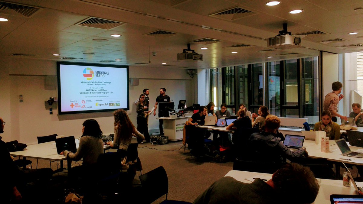
This meeting will now be followed by the Missing Maps May Mapathon - Cambridge from 18:00 - 20:30, which will also be hosted at the British Antarctic Survey. We also plan to squeeze in a post-mapping drink at The Punter just down the road. Open source GIS followed by humanitarian mapping, followed by free pizza and a pint - what more could you ask for!?
Missing Maps May Mapathon - Cambridge
11 April 2017 8:38am
Missing Maps April Mapathon - Cambridge
21 March 2017 7:30pm
6 April 2017 12:07pm
Hi Steph,
It was fantastic! We had a full house, with all 40 tickets sold out and really good attendance rate. We were mapping an area of Zimbabwe for the Clinton Health Access Initiative's malaria program. We were joined remotely by some collaborators at OpenStreetMap Bangladesh, and together we completed > 70% of the task. The next Cambridge Missing Maps is going to be at the British Antarctic Survey on Thursday 18th May and you can register here! We hope to include the David Attenborough Building on the Missing Maps Cambridge circuit for future events. The Cambridge Conservation Forum GIS Group are also planning to hold a MapforEnvironment event in the very near future, which will of course be advertised on WILDLABS.NET!
Thanks!
6 April 2017 2:11pm
Sounds awesome! Will you be working to finish the other 30% at the next meeting, or working on a new project?
Adding in a great photo you posted from the event on Twitter last night :)
11 April 2017 8:33am
Thanks for adding the photo from the event. Missing Maps is becoming really popular, so tasks get completed quite quickly. We shared the task numbers for people to finish off at home if they wanted to, but by the time of next month's mapping party, this task will long have been completed so we'll be working on another one! I hope you can make it on Thursday 18th May.
Lasers in the Jungle Somewhere: How Airborne LiDAR Reveals the Structure of Forests
 Phil Wilkes
4 April 2017 12:00am
lidar imagery
6 March 2017 11:53am
7 March 2017 11:11am
Hi Paul,
So you have had the good fortune to make this ask during our annual #Tech4Wildlife photo challenge, but unfortunately you've been foiled on this ask (unlike the acoustic and camera trapping photos) - we've yet to see any lidar images shared in the photo challenge. So I'll add a request on top of your request.. if you do have some lidar images that you are willing to share with Paul, please add them to the #tech4wildlife photo challenge mix over on Twitter as well!
To participate this year, all you need to do is:
- Take a photo of how you are using tech to save wildlife
- Share it on Twitter: tell us a bit about your work and the tech featured
- Remember to use the hashtag #Tech4Wildlife and tag us at @WILDLABSNET
Cheers,
Steph
31 March 2017 10:19am
Hi @P.Glover.Kapfer
Have you looked at the Environment Agency LiDAR data available under the Open Government Licence and available from http://environment.data.gov.uk/ds/survey/index.jsp#/survey?
It might also just be worth asking Amphibian and Reptile Conservation whether their LiDAR data are available. They have a 2 ppm coverage of the New Forest National Park from 2015 which is shared with Natural England (contact Arne Loth). The New Forest National Park Authority also have a 4 ppm dataset from a few years previous, though I'm not sure what the copyright status is with that one (contact Lawrence Shaw).
As a fairly frequent LiDAR user, I'd be interested to know more about your best practice guidelines and website.
Thom
Welcome to the GIS group!
16 March 2017 5:59pm
30 March 2017 4:25pm
Hello. I'm working at Korea National Park Service, GISP, and a charter member of OSGeo Foundation. I'm teaching various open source GIS applications such as QGIS, GRASS GIS, Orfeo ToolBox, OpenDroneMap. Nice to know this GIS group!

30 March 2017 5:47pm
Hello, I am currently using QGIS for assessing conservation planning effectiveness and identifying gaps in networks of protected areas in the Neotropics. It's really nice to be able to share and gather knowledge about GIS functionalities.

31 March 2017 12:52am
Hi, I'm a GIS consultant to conservation and research groups, mostly using ArcGIS and, increasingly, QGIS. Lately I've been doing a lot of work with satellite imagery. I've done quite bit of Python programming as well. I hope to meet like-minded folks for information-sharing and maybe even collaboration.
RGS Geo-technologies for field research workshops
21 March 2017 7:54pm

29 March 2017 4:42pm
Thanks for sharing. It looks as though they've recently been cancelled.
29 March 2017 4:59pm
Ah - a shame they've been cancelled, thanks for that update Joel. As an advanced GIS user yourself (you work in GIS with Vulcan, right?), would the higher-level course Thom's looking into organising be of interest?
29 March 2017 6:13pm
Thanks for the update, @joelm . I wonder why they were cancelled - lack of uptake or something else? I'll see what I can find out.
Conservation GIS Group Social
21 March 2017 7:25pm
27 March 2017 7:35am
Last week's GIS social topics included:
- IfSAR and InSAR Interferometric synthetic aperture radar, as used by the German Aerospace Center (DLR) in their new TanDEM-X high resolution global digital elevation model. The new GDEM has a vertical accuracy of < 1 metre and an xy resolution of 6 metres. You can read more on the project web page https://tandemx-science.dlr.de/.
- Using Maxim iButton termperature data logger arrays to monitor the diurnal temperature fluctuations of different habitats and microhabitats. We also touched on sampling design and interpolation methods.
- Towards the end of the evening we discussed the difference between geodesic and Euclidian distances, the planar nature of the solar system (see Laplace's invariable plane) and whether the galaxy has a ‘right way up’.
Beverages of choice were Greene King’s Abbot Ale and IPA Special Reserve. Put the next GIS social date in your calendar now and don’t miss out – it’s Thursday April 13th.
The Return of the CCF Conservation GIS Group!
17 March 2017 9:03am
Conservation GIS Group Social
6 March 2017 8:06am
CCI International GIS Day
8 November 2016 1:14pm
8 December 2016 5:58pm
CCI International GIS Day recap
GIS Day at CCI was a great success! We kept it short to try and maximise engagement and so that everyone could meet each other. Attendees have been sent a follow-up email, but if you've not received this or you want to know more then please message me for details.
It would be a great mini-legacy and a testament to the event if attendees could post a brief introduction / recap on this thread; just stating your occupation and interests, or anything that you took away from the event. Thanks to the organising committee @jonathanknox.ffi (FFI), @Tomswinfield (RSPB) and Andy Arnell (UNEP-WCMC). And thanks for the photos, @StephODonnell !
8 December 2016 6:08pm
I'm a GIS Analyst at the RSPB. I'm part of a great team providing GIS technical support within the society. I get to work on everything from producing detailed reserve maps to analysing the effectiveness of protected areas and mapping habitats using remote sensing data. I also get to empower my colleagues to create their own maps by supporting our ArcGIS users and working on our in-house broweser-based GIS Merlin. Right now I'm working on developing our use of Unmanned Aerial Vehicles to produce orthomosaic habitat maps and vegetation height models on our reserves. I'm always interested to hear about other people's projects!
5 January 2017 9:35am
I'm a software developer with the British Trust for Ornithology (BTO), working on online map-based applications for bird surveys (e.g. BirdTrack). My main focus is the databases (Oracle & Postgres, including spatial features) and preparing the GIS data using ArcGIS or QGIS. Our online applications are key to receiving survey data from a large number of volunteers and displaying the survey results back to the volunteers.
I also act as central contact point within the BTO for queries about GIS.
Measuring distances between GPS points from a satellite collar
12 July 2016 6:55pm
14 July 2016 11:53am
Figured it out.
Even though I was in the right projection (ie: UTM), I was not aware that I had to calculate the coordinates myself. All you need to do is create two new columns for X and Y coordinates, and right click in each column: choose calculate geometry, and then select X and Y according to the column you're at. It calculates the coordinates in your chosen unit (mine is meters). The "new" coordinates can be used then in adehabitatLT to obtain distance measurements in a trajectory.

4 December 2016 5:21am
Hey MGatta, I'm working with adehabitatLt as well, i have a good paper on spatial referencing your data and changing your coordinates to UTM, if you want it (by C.J.Brown).
I assume that the process you did to change to meters was in Excell, before using the coordinates in R?
Kind regards,
Sam
Conservation Leadership Programme 2017 Award
21 November 2016 12:00am
Neotropical Migratory Bird Conservation Act grants via USFWS
8 November 2016 12:00am
Basic GIS vector and raster datatsets

7 November 2016 1:47pm
How do Wildlife Crime Experts view Remote Sensing Technologies used to Combat Illegal Wildlife Crime?
7 November 2016 12:00am
Earth Observation from Space: the Optical View
22 September 2016 9:56am
22 September 2016 4:37pm
Really interesting project! When are you expecting to have some results? Do you think the use of drones was beneficial for the project? Will you be using them again?
19 October 2016 8:19am
We're expecting to have some results by the end of the year. We can already see that the use of a drone was beneficial for media and communication for the expedition, but I expect it to come into its own when we make full use of the orthomosaic aerial photography and digital surface model from photogrammetry which we are hoping to use in order to elucidate metrics of vegetation structure in relation to the forest edge. If we discover something really cool, I will post it here!
19 October 2016 8:23am
Now the course is officially over, I wonder how people found it? Too difficult, too easy or just right?
Request for Expression of Interest for Individual Consultants to Conduct Remote Sensing and Geospatial Analysis
4 August 2016 12:00am
Apply now for the 2016 Annual Geo for Good User Summit
16 June 2016 12:40am
Drone Training in the U.S.

5 May 2016 9:46am
Conservation apps with a GPS focus
5 April 2016 3:27pm

26 April 2016 2:34pm
My goto application is CyberTracker. It can be adapted on your desktop exactly to record the data that you want (including pictures and GPS reading, but not compass direction).

26 April 2016 4:53pm
Another option is OruxMaps, free for android, not very intuitive but very powerful. But it's important to bear in mind that phone GPS accuracy can be lower than "traditional" GPS, specially when part of the sky is blocked.
Here is a test https://blogs.esri.com/esri/arcgis/2013/07/15/smartphones-tablets-and-gps-accuracy/
ZSL Symposium: Space - the final frontier for biodiversity monitoring?
19 April 2016 2:29pm
19 June 2017 2:37pm
I was just thinking along those lines. Yes, whatever you think would be the best structure for collating learning resources.