With new technologies revolutionizing data collection, wildlife researchers are becoming increasingly able to collect data at much higher volumes than ever before. Now we are facing the challenges of putting this information to use, bringing the science of big data into the conservation arena. With the help of machine learning tools, this area holds immense potential for conservation practices. The applications range from online trafficking alerts to species-specific early warning systems to efficient movement and biodiversity monitoring and beyond.
However, the process of building effective machine learning tools depends upon large amounts of standardized training data, and conservationists currently lack an established system for standardization. How to best develop such a system and incentivize data sharing are questions at the forefront of this work. There are currently multiple AI-based conservation initiatives, including Wildlife Insights and WildBook, that are pioneering applications on this front.
This group is the perfect place to ask all your AI-related questions, no matter your skill level or previous familiarity! You'll find resources, meet other members with similar questions and experts who can answer them, and engage in exciting collaborative opportunities together.
Just getting started with AI in conservation? Check out our introduction tutorial, How Do I Train My First Machine Learning Model? with Daniel Situnayake, and our Virtual Meetup on Big Data. If you're coming from the more technical side of AI/ML, Sara Beery runs an AI for Conservation slack channel that might be of interest. Message her for an invite.
Header Image: Dr Claire Burke / @CBurkeSci

Explore the Basics: AI
Understanding the possibilities for incorporating new technology into your work can feel overwhelming. With so many tools available, so many resources to keep up with, and so many innovative projects happening around the world and in our community, it's easy to lose sight of how and why these new technologies matter, and how they can be practically applied to your projects.
Machine learning has huge potential in conservation tech, and its applications are growing every day! But the tradeoff of that potential is a big learning curve - or so it seems to those starting out with this powerful tool!
To help you explore the potential of AI (and prepare for some of our upcoming AI-themed events!), we've compiled simple, key resources, conversations, and videos to highlight the possibilities:
Three Resources for Beginners:
- Everything I know about Machine Learning and Camera Traps, Dan Morris | Resource library, camera traps, machine learning
- Using Computer Vision to Protect Endangered Species, Kasim Rafiq | Machine learning, data analysis, big cats
- Resource: WildID | WildID
Three Forum Threads for Beginners:
- I made an open-source tool to help you sort camera trap images | Petar Gyurov, Camera Traps
- Batch / Automated Cloud Processing | Chris Nicolas, Acoustic Monitoring
- Looking for help with camera trapping for Jaguars: Software for species ID and database building | Carmina Gutierrez, AI for Conservation
Three Tutorials for Beginners:
- How do I get started using machine learning for my camera traps? | Sara Beery, Tech Tutors
- How do I train my first machine learning model? | Daniel Situnayake, Tech Tutors
- Big Data in Conservation | Dave Thau, Dan Morris, Sarah Davidson, Virtual Meetups
Want to know more about AI, or have your specific machine learning questions answered by experts in the WILDLABS community? Make sure you join the conversation in our AI for Conservation group!
No showcases have been added to this group yet.
Zoological Society London (ZSL)
- 0 Resources
- 2 Discussions
- 9 Groups
Data scientist with expertise in Computer vision and remote sensing and a passion to work for the environment.
- 0 Resources
- 4 Discussions
- 5 Groups
Smithsonian Institution
- 0 Resources
- 0 Discussions
- 13 Groups
Ecosystem Intelligence Lead at Wedgetail, living in Lutruwita/Tasmania
- 0 Resources
- 1 Discussions
- 7 Groups
- @mwanikimm
- | Mr
Ol Pejeta Conservancy
Technology and Innovations Manager
- 0 Resources
- 0 Discussions
- 7 Groups
- 0 Resources
- 0 Discussions
- 1 Groups
- @och3k
- | she/her
- 0 Resources
- 0 Discussions
- 7 Groups
- @mariaptoro
- | she/her
Colombian biologist passionate about behavioral and evolutionary ecology, specializing in amphibians. My research explores animal communication and how environmental factors shape behavior and adaptation.
- 0 Resources
- 0 Discussions
- 9 Groups
- @Nate
- | He/Him
I support the technology for over 200 of the state's top scientists in the Office of Resource Conservation at IDNR and the Illinois Nature Preserves Commission.

- 0 Resources
- 2 Discussions
- 4 Groups
- @aranFish
- | He/Him
CatchCam Technologies
Former CTO at SafetyNet Technologies


- 1 Resources
- 1 Discussions
- 6 Groups
MSc student in wildlife management and conservation


- 0 Resources
- 2 Discussions
- 12 Groups
- @ahmedjunaid
- | He/His
Zoologist, Ecologist, Herpetologist, Conservation Biologist


- 74 Resources
- 7 Discussions
- 25 Groups
The AI for Climate Resilience Program is a new initiative by Klarna that aims to support pioneering projects that leverage artificial intelligence for climate adaptation in underserved, climate-vulnerable regions.
6 August 2025
Read about the advice provided by AI specialists in AI Conservation Office Hours 2025 earlier this year and reflect on how this helped projects so far.
6 August 2025
If you're a Post-Doctoral Fellow, a PhD student, or a member of the research staff interested in applying your computational skills to support active research publications, please read on to learn about the Cross-...
5 August 2025
If you're a PhD student, post-doc, advisor, or marine expert - Plan Vivo is looking for you!
5 August 2025
A free, self-paced course series for nonprofit professionals is available through August 31.
31 July 2025
Link
The GeoCroissant team is conducting a short survey (5–10 minutes) to better understand user needs and preferences around geospatial metadata in machine learning. Your input will support the development of an open...
28 July 2025
Careers
This role will investigate the potential of large-scale deep learning models, for constructing 3D models of coral reefs
28 July 2025
🔥 Excited to join the WILDLAB community! I’m Robert Chonge — a Full Stack Developer with a passion for AI and Big Data, now channeling that tech firepower toward environmental conservation.Let’s turn data into action...
26 July 2025
El Instituto Humboldt está buscando un(a) Desarrollador(a) de Inteligencia Artificial que quiera aplicar su experiencia en Python y procesamiento de lenguaje natural para proteger la biodiversidad.
25 July 2025
The Marine Innovation Lab for Leading-edge Oceanography develops hardware and software to expand the ocean observing network and for the sustainable management of natural resources. For Fall 2026, we are actively...
24 July 2025
Dear colleagues, I'd like to share with you the output of the project KIEBIDS, which focused on using AI to extract biodiversity-relevant information from museum labels. Perhaps it can be applied also to other written...
17 July 2025
The Department of AI and Society (AIS) at the University at Buffalo (UB) invites candidates to apply for multiple positions as Assistant Professor, Associate Professor, or Full Professor. The new AIS department was...
8 July 2025
August 2025
event
September 2025
event
event
event
event
October 2025
event
event
event
December 2025
event
March 2026
April 2025
event
event
March 2025
event
17 Products
Recently updated products
| Description | Activity | Replies | Groups | Updated |
|---|---|---|---|---|
| Environment conservation in Great Rift Valley. |
|
AI for Conservation | 8 minutes 42 seconds ago | |
| Hi Chris! Send me a direct message and we can have a chat! |
+5
|
AI for Conservation, Autonomous Camera Traps for Insects, Camera Traps | 11 hours 24 minutes ago | |
| Hey people of the world. 10 days ago I posted here about our new GUI tool where one could drag-n-drop an image and get animals detected on... |
|
AI for Conservation | 1 day 6 hours ago | |
| Hi @CourtneyShuert We support NOAA with AI for individual ID for belugas (but from aerial and from lateral surface too). If some of our techniques can be cross-applied... |
|
AI for Conservation, Data management and processing tools | 6 days 18 hours ago | |
| Hello Eugene, I just tried your service:Was wondering how possible will it be to have the option to upload a second image and have a comparison running to let the user know if... |
|
AI for Conservation, Camera Traps, Data management and processing tools, Software Development | 1 week ago | |
| Kudos for such an innovative approach—integrating additional sensors with acoustic recorders is a brilliant step forward! I'm especially interested in how you tackle energy... |
|
Acoustics, AI for Conservation, Latin America Community, Open Source Solutions | 1 week ago | |
| Thank you for your reply! It surely helps, we have use exif for a while to read metadata from images, when there is information available. Could be nice to maybe see if we... |
|
AI for Conservation, Camera Traps | 1 week 3 days ago | |
| You could just throw out that data, but I think you'd be doing yourself a disservice and missing out on some interesting insights. Are you training the AI with just pre-COVID... |
|
AI for Conservation, Animal Movement, Data management and processing tools, Human-Wildlife Coexistence | 1 week 6 days ago | |
| Would love to collaborate on this we are curently building agents for conservation Kind regardsOlivier |
|
AI for Conservation, Community Base | 2 weeks ago | |
| This is such a compelling direction, especially the idea of linking unsupervised vocalisation clustering to generative models for controlled playback. I haven’t seen much done... |
|
Acoustics, AI for Conservation, Emerging Tech | 2 weeks 2 days ago | |
| Hello.I am in need of assistance.I need a website for a project I am working on.Thanks 😊 |
|
Software Development, AI for Conservation | 2 weeks 4 days ago | |
| Wow this is amazing! This is how we integrate Biology and Information Technology. |
|
Camera Traps, AI for Conservation, Build Your Own Data Logger Community, Data management and processing tools, Marine Conservation, Protected Area Management Tools, Geospatial | 2 weeks 4 days ago |
What are open source solutions anyway?
1 November 2024 2:21pm
11 December 2024 9:04pm
Sorry to be a stickler on syntax when there is a richer discussion about community here - but I believe a true "open source" project is a functionally complete reference design that anyone can build upon with no strings attached. If the community isn’t provided with enough information to fully build and iterate on the design independently, then the project doesn’t truly meet the spirit of open source.
As a developer and engineer, I’ve observed that sometimes projects crowdsource free engineering work under the guise of being "open source." While this can have benefits, it can feel like asking for a free lunch from clients and customers.
Advanced features—like enterprise-level data management or tools for large-scale deployments—can reasonably remain proprietary to sustain the project financially. Transparency is critical here. If the foundational components aren’t fully open, it would be more accurate to describe the project as "community-driven" or "partially open." And as an engineer/developer I wouldn't be angry when I went to explore the project marked "open source" only to find that I have been lied to.
Just my two cents, and I really appreciate the thoughtful discussion here. The open source community has been a massive influence on me. Everything I do at work would not be possible without it. In many ways, "open source" or "public domain" projects represents the true know-how of our society.
4 March 2025 3:27pm
Thanks again for the interesting discussion everyone!
Just a note that while I touched on it in my opening post above, there were still questions in this thread about what open source tech means. I tried to address that in my new thread here:
Definitions for open source software & hardware and why they're important
27 February 2025 10:58am
28 February 2025 5:26pm
Thanks for this excellent and thought-provoking post, Pen. I agree this is a binary yes/no issue, but there is a spectrum. There could also be philosophical nuances. For example, does excluding honey from a vegan diet meet the ethical criteria of veganism? It's an animal product, so yes, but beekeeping generally doesn't have the same exploitative potential as cow, sheep, or pig husbandry, right? However, looking strictly at the definition, honey is out if you want to be vegan.
Back to software! Isn’t the main issue that companies falsely claim to offer open source hardware/software? To avoid this, do you then have to create an accreditation system? Who polices it? Is it fair? Would users care that their software has the accredited open source stamp of approval? Ultimately, we need definitions to define boundaries and speak a common language.
4 March 2025 3:21pm
Thanks @VAR1 great insights! Funny you mentioned the honey thing, @hikinghack said the same in response on the GOSH forum.
I think the point I'm trying to make with the vegan comparison is that while it might not be 100%, it is close enough for us to have productive conversations about it without running in circles because we can't even agree on what we are talking about.
As for open source tech, there actually is accreditation for open source hardware (at least of a sort). The Open Source Hardware Association has a fairly mature certificate program:
OSHWA Certification
Certification provides an easy and straightforward way for producers to indicate that their products meet a well-defined standard for open-source compliance.
I am genuinely undecided whether such a formal accreditation system is required for open source software. My undecided-ness comes back to the food/agriculture analogy, where a similar issue exists for organic certification. Being certified organic could possibly, in some cases, be beneficial. However, certification can also be very onerous for small organic farmers who can't afford to get it.
But before we even think about accreditation, I echo your last sentence that we need definitions to define boundaries. These definitions, as I argue in my original post above, is not only about principles and philosophy, they are also a practical necessity for enabling effective communication!
What is your favourite social media these days?
29 January 2025 7:27am
3 March 2025 9:22pm
Good news, we are BACK on Bluesky! Give us a follow if you're on it!
@wildlabs.bsky.social on Bluesky
The global, open online community dedicated to conservation technology. How are you using #Tech4Wildlife? http://linktr.ee/wildlabsnet
3 March 2025 9:23pm
We were recently dealing with some moderation issues with the Bluesky team but are happy to report we're back! Give us a follow :)
@wildlabs.bsky.social on Bluesky
The global, open online community dedicated to conservation technology. How are you using #Tech4Wildlife? http://linktr.ee/wildlabsnet
4 March 2025 8:36am
Linkedin mainly.
iNaturalist and eBird ofc but these are more communities than real social networks.
But, and this is a real advice, a good RSS feed reader with all your trusted sources and then you don't need any other social network.
:O)
Career Move: Defence AI to Conservation AI
19 February 2025 12:01pm
22 February 2025 2:21pm
Hey Margaux,
Thanks so much for such an informative response, really appreciate it. I’ll be look into every avenue you’ve suggested!
And congratulations on the job, your company honestly looks like the dream. Well done for sticking it out for the right opportunity.
Re. your point on software integration, I’m a Data Scientist primarily but much of my current work revolves around integrating off-the-shelf models (e.g. vision-language models) into existing systems/pipelines, and I think this aligns well with the state of the conservation tech field at the moment. With new state-of-the-art models emerging from the tech giants on an almost monthly basis I doubt small conservation NGO’s will be reinventing the wheel in-house…
I just want to collaborate with likeminded people and devote my knowledge/skills/creativity to a cause I really believe in, and am happy to wait as long as it takes to find the right opportunity :)
Just making notes on what you’ve said now. Will be reaching out to all these companies you’ve mentioned, probably including yours haha
Thanks again!
Luke
26 February 2025 3:41pm
Hi Luke, I saw this job posted on the AI for Conservation Slack community the other day, no idea if it's a fit (haven't checked your resume or read the full job description) but you might want to join that group as well as check out this post:
28 February 2025 1:05pm
Hi Maureen, thanks a lot for this. Seemed more or less perfect so I applied :)
Also didn't realise there was a slack community so I'll be scanning that too...
Animal Detect - 3 spots available to test phase
27 February 2025 8:34am
The 100KB Challenge!
7 February 2025 11:47am
20 February 2025 9:13am
Nice one - what kind of thing would you use this for?
~500mA peak current, it has a similar power profile as the current RockBLOCK product, in that it needs lots of juice for a for a small period of time (to undertake the transmission) we include onboard circuitry to help smooth this over. I'll be able to share more details on this once the product is officially launched!
20 February 2025 9:13am
~500mA peak current, it has a similar power profile as the current RockBLOCK product, in that it needs lots of juice for a for a small period of time (to undertake the transmission) we include onboard circuitry to help smooth this over. I'll be able to share more details on this once the product is officially launched!
20 February 2025 9:31am
Hi Dan,
Not right now but I can envision many uses. A key problem in RS is data streams for validation and training of ML models, its really not yet a solved problem. Any kind of system that is about deploying and "forgetting" as it collects data and streams it is a good opportunity.
If you want we can have a talk so you tell me about what you developed and I'll see if it fits future projects.
All the best
Switch to Conservation IT
10 June 2022 1:47am
25 February 2025 2:16am
Some of you may have seen this post of mine from back in 2022. With the hope that it will help me put my foot through the door, I have now completed my Masters in AI and ML. Purely to work in preferably research and dev oriented opportunities in conservation and wild life.
If anyone can advice/ assist/ wants to network, please drop a note.
25 February 2025 6:42am
Hey @soumyabhatta, welcome in! I had a similar career switch as you, but less experience, and coming from Robotics background. :)
What helped our startup to get a "tech introduction" in to the world of Wildlife & Conservation was going through Dan Morris' blog where he showcases all of the relevant tech he knows about.
I cannot recommend you enough to get a read on it:
25 February 2025 1:57pm
Thanks @eugenegalaxy . Much appreciated and I will go through this thoroughly!
INTERNSHIP FOR COMPUTER VISION BASED INSECT DETECTION AND CLASSIFICATION
25 February 2025 10:46am
AI/ML x Nature Job
Building the perfect camera trap (Guide)
17 February 2025 8:06am
18 February 2025 4:15pm
If you are the least interested in camera traps, you should definately go and check out Hugo's interesting article!
Cheers,
Lars
21 February 2025 4:22pm
Great Article! (and thanks for the ping re: "PIR Sensors" )
I like the idea of a simple magnetic trigger. As an alternative, I've often wondered about an ultra-low-power "wake on Radio" receiver that could be connected wirelessly to a range of different trigger devices.
Also, there is an interesting tradeoff between battery life and trigger speed you didn't cover. Namely, all the commercial trail cameras I know of turn themselves almost completely off between triggers to save power. An ultra low power "boot controller" monitors the PIR sensor, and when triggered, initiates the boot sequence for the main SoC. I've found that the boot process (rather than PIR bandwdith, configuring the image sensor, shutter speed, etc. ) dominates the "trigger time". It is remarkable that this all happens in less than 400 ms for the newer trail cameras. There are some hacks to help this along, for example, locating the time-critical code early in the EEPROM boot image so that the firmware can start executing before all the firmware is loaded (ask me how I discovered this).
For those interested in the inner workings of a typical commercial trail camera, check out my series of articles documenting reverse engineering (and hacking) a few Browning models.
Deep Tech: Hacking Trail Camera Firmware 1 - Overview - Winterberry Wildlife
Introductions to tools and flow I used to reverse engineer embedded firmware for Browning trail cameras, and to introduce new functions.
23 February 2025 8:11am
Hey Bob, thanks for the kind words! Your articles on Winterberry Wildlife have really been a big inspiration for me! There are extremely limited numbers of articles on trial cameras, and you have some nice in-depth hardware level which I have been reading 😊
You are completely right about the battery life and trigger speed tradeoff. If I remember right, there are a few cameras which offered “real time” images but in return the battery was drained in a few days and people started to complain on forums. In early stages of development there is also much about limiting the services at boot, as you mention putting the camera function as early in the boot sequence as possible, creating your own camera configs and so on.
Free tool to generate your spirit animal
19 February 2025 7:58am
19 February 2025 2:10pm
Just tried it again :D 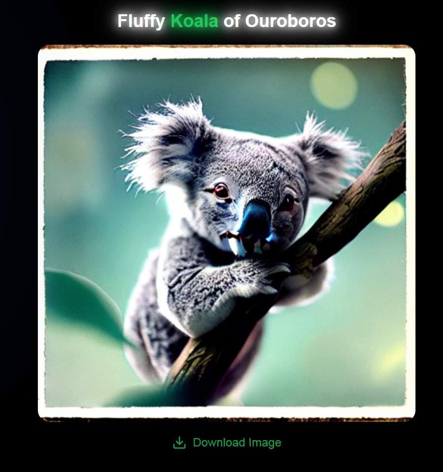
19 February 2025 2:18pm
Not bad, sir, not bad!
19 February 2025 2:19pm
This is probably the most realistic one I've seen made by this tool (stable-difussion v1.5)
Explore the PANGEA Project with Elsa Ordway
17 February 2025 11:45pm
GhostNetZero.ai
13 February 2025 5:40pm
Applications are open for the Sustainability Leadership Recognition in Robotics!
12 February 2025 4:50pm
AddaxAI - Free AI models for camera traps photos identification
3 April 2024 7:16am
12 February 2025 2:44pm
Yes! The plan is definitely there :) But also there are some other models I want to add. It's just a matter of finding enough time to do the work ;)
12 February 2025 2:47pm
Hi Caroline @Karuu ,
The model is still in development. Unfortunately, I'm not sure how long it will take as it is not my top priority at the moment. However, you can still use EcoAssist to filter out the empty images, which is generally already a huge help.
Would that work for the time being?
12 February 2025 2:55pm
Hi Lucie @luciegallegos ,
Great to see ecoSecrets and happy to collaborate in any way I can! All EcoAssist's models are open-source, and the inference code too. With regards to planning a meeting, would you mind reaching out to me on email? Then we can plan a video call to discuss this further :)
Camera Trap Data Visualization Open Question
4 February 2025 3:00pm
12 February 2025 12:31pm
Hey Ed!
Great to see you here and thanks a lot for your thorough answer.
We will be checking out Trapper for sure - cc @Jeremy_ ! A standardized data exchange format like Camtrap DP makes a lot of sense and we have it in mind to build the first prototypes.
Our main requirements are the following:
- Integrate with the camtrap ecosystem (via standardized data formats)
- Make it easy to run for non technical users (most likely an Electron application that can work cross OSes).
- Make it useful to explore camtrap data and generate reports
In the first prototyping stage, it is useful for us to keep it lean while keeping in mind the interface (data exchange format) so that we can move fast.
Regards,
Arthur
12 February 2025 1:36pm
Quick question on this topic to take advantage of those that know a lot about it already. So once you have extracted all your camera data and are going through the AI object detection phase which identifies the animal types. What file formation that contains all of the time + location + labels in the photos data do the most people consider the most useful ? I'm imagining that it's some format that is used by the most expressive visualization software around I suppose. Is this correct ?
A quick look at the trapper format suggested to me that it's meta data from the camera traps and thus perform the AI matching phase. But it was a quick look, maybe it's something else ? Is the trapper format also for holding the labelled results ? (I might actually the asking the same question as the person that started this thread but in different words).
12 February 2025 2:04pm
Another question. Right now pretty much all camera traps trigger on either PIR sensors or small AI models. Small AI models would tend to have a limitation that they would only accurately detect animal types and recognise them at close distances where the animal is very large and I have question marks as to whether small models even in these circumstances are not going to make a lot of classification errors (I expect that they do and they are simply sorted out back at the office so to speak). PIR sensors would typically only see animals within say 6m - 10m distance. Maybe an elephant could be detected a bit further. Small animals only even closer.
But what about when camera traps can reliably see and recognise objects across a whole field, perhaps hundreds of meters?
Then in principle you don't have to deploy as many traps for a start. But I would expect you would need a different approach to how you want to report this and then visualize it as the co-ordinates of the trap itself is not going to give you much information. We would be in a situation to potentially have much more accurate and rich biodiversity information.
Maybe it's even possible to determine to a greater degree of accuracy where several different animals from the same camera trap image are spatially located, by knowing the 3D layout of what the camera can see and the location and size of the animal.
I expect that current camera trap data formats may fall short of being able to express that information in a sufficiently useful way, considering the in principle more information available and it could be multiple co-ordinates per species for each image that needs to be registered.
I'm likely going to be confronted with this soon as the systems I build use state of the art large number of parameter models that can see species types over much greater distances. I showed in a recent discussion here, detection of a polar bear at a distance between 130-150m.
Right now I would say it's an unknown as to how much more information about species we will be able to gather with this approach as the images were not being triggered in this manner till now. Maybe it's far greater than we would expect ? We have no idea right now.
Applying Open-source Computer Vision Models to Camera Trap Images
22 February 2025 6:19am
24 February 2025 4:28pm
1 July 2025 10:36pm
The power of bioinformatics and next-generation sequencing (NGS) in conservation biology.
10 February 2025 1:40pm
Low-power acoustics systems
27 January 2025 1:44pm
10 February 2025 10:42am
10 February 2025 10:49am
Hi Julia,
Thank you for your reply. Your work on connected acoustic recorders sounds very interesting, and we’d love to learn more about your application and the enhancements to Bugg. We’ll contact you soon to arrange a discussion.
Looking forward to it!
Thank you,
Best regards,
Sebastian
10 February 2025 10:52am
Hi Lucille,
Thank you for your reply! We’d be really interested in learning more about your developments. We’ll contact you soon to arrange a discussion.
Thank you.
Best regards,
Sebastian
Training Educators in Nigeria how to save the Earth with Empathy & Computational thinking; use AI robotics #hummingbirdbit to make a bee waggle! 🐝
10 February 2025 1:48am
Light in the dark: How AI and FLIR cameras are saving black rhinos in Kenya
8 February 2025 12:49pm
AI for Bird and Bat Recognition
7 February 2025 11:57am
7 February 2025 5:06pm
Hi Lorenzo,
I highly recommend the OpenSoundscapes package (developed by the Kitzes Lab at U Pittsburgh) - there are workflows to build your own CNNs there, the documentation is really thorough, and the team are very responsive to inquiries. They also have a bioacoustics 'model zoo' that lists relevant models. The Perch model from Google would be good to look into as well.
Some recent papers I've seen that might also be worth checking out -
- Advanced montane bird monitoring using self-supervised learning and transformer on passive acoustic data
- A good horizon scan paper - The potential for AI to revolutionize conservation: a horizon scan
- Challenges and solutions for ecologists adopting AI
- And perhaps not directly related, but a new framework for deploying edge models onto recorders was just released - acoupi: An Open-Source Python Framework for Deploying Bioacoustic AI Models on Edge Devices
Hope that helps a bit!
Writing about conservation technologies on LinkedIn
7 February 2025 2:55pm
acoupi: An Open-Source Python Framework for Deploying Bioacoustic AI Models on Edge Devices
7 February 2025 1:39am
SPOTS Internship Programme
6 February 2025 3:38pm
Machine learning for bird pollination syndromes
25 November 2024 7:30am
3 January 2025 3:55am
Hi @craigg, my background is machine learning and deep neural networks, and I'm also actively involved with developing global geospatial ecological models, which I believe could be very useful for your PhD studies.
First of all to your direct challenges, I think there will be many different approaches, which could serve more or less of your interests.
As one idea that came up, I think it will be possible in the coming months, through a collaboration, to "fine-tune" a general purpose "foundation model" for ecology that I'm developing with University of Florida and Stanford University researchers. More here.
You may also find the 1+ million plant trait inferences searchable by native plant habitats at Ecodash.ai to be useful. A collaborator at Stanford actually is from South Africa, and I was just about to send him this e.g. https://ecodash.ai/geo/za/06/johannesburg
I'm happy to chat about this, just reach out! I think there could also be a big publication in Nature (or something nice) by mid-2025, with dozens of researchers demonstrating a large number of applications of the general AI techniques I linked to above.
6 February 2025 9:57am
We are putting together a special issue in the journal Ostrich: Journal of African Ornithology and are welcoming (review) papers on the use of AI in bird research. https://www.nisc.co.za/news/202/journals/call-for-papers-special-issue-on-ai-and-ornithology
AI in Ornithology
1 November 2024 1:10pm
4 November 2024 6:00am
Thanks for flagging! We might be interested to submit our work on acoustic monitoring system.
6 February 2025 9:50am
Hi Adrien,
Submissions are open for the special addition. Please email David Ehlers Smith - david.ehlers.smith@birdlife.org.za for more details. We are also soliciting reviewers.
Best,
Yvette
Summer Internships at SDZWA (Conservation Technology Lab)
6 February 2025 3:49am
SDZWA Conservation Tech Summer Fellowship
5 February 2025 9:09pm



















11 December 2024 12:34pm
Open source technologies are a game-changer for biodiversity conservation. They give us the freedom to use, study, modify, and share vital tools and knowledge that help advance research in meaningful ways. For conservationists, this means we can adapt technologies to meet local needs, improve existing tools, and make new innovations available to everyone—creating a more collaborative and sustainable future for our planet.
It’s exciting to see the impact of open source in conservation already, with tools like Mothbox, Fieldkit, and OpenCTD helping to drive progress. I'm curious—how do the formal definitions of open source resonate with you? How do they shape the way we approach conservation?
Also, if you're interested in how open source AI can support conservation efforts, check out this article: Open Source AI Agents: How to Use Them and Best Examples.
Can’t wait to hear your thoughts! Let's keep the conversation going.