Group curators

Vance Russell

Ahmed Junaid
- @ahmedjunaid
- | He/His

Elsa Carla De Grandi
Fauna & Flora
Who We Are
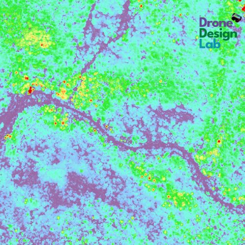
Geospatial data and analysis is critical for conservation, from planning to implementation and measuring success. Every day, mapping and spatial analysis are aiding conservation decisions, protected areas designation, habitat management on reserves and monitoring of wildlife populations, to name but a few examples. The Geospatial group focuses on all aspects of this field, from field surveys to remote sensing and data development/analysis to GIS systems.
How to Get Started
Want to learn more about how remote sensing is used in conservation? Check out the first two episodes of this season of Tech Tutors, where our Tutors answer the questions How do I use open source remote sensing data to monitor fishing? and How do I access and visualise open source remote sensing data in Google Earth Engine? You can also check out our Virtual Meetup Archive for a range of panels that overlap with Geospatial topics, or take a look at our Earth Observation 101 lecture series from Dr. Cristian Rossi.
Our Purpose
The WILDLABS Geospatial Group is for conservation practitioners, geospatial analysts, and academics that want to:
- Share geospatial resources, best practices, data, and ideas;
- Network amongst geospatial and data practitioners;
- Create peer learning opportunities;
- Promote the use of free and open-source geospatial software; and
- Improve the use of GIS software and geospatial analyses in conservation management and research.
Group curators

Over 35 years of experience in biodiversity conservation worldwide, largely focused on forests, rewilding and conservation technology. I run my own business assisting nonprofits and agencies in the conservation community


- 5 Resources
- 62 Discussions
- 12 Groups
- @ahmedjunaid
- | He/His
Zoologist, Ecologist, Herpetologist, Conservation Biologist


- 63 Resources
- 7 Discussions
- 26 Groups

Fauna & Flora
Remote Sensing Scientist, Conservation Technology & Nature Markets @ Fauna & Flora - WILDLABS Geospatial Group Co-Lead

- 34 Resources
- 28 Discussions
- 8 Groups

Technologist and Visual storyteller focusing on social, conservations issues.


- 1 Resources
- 42 Discussions
- 17 Groups

- @KateNewtonCorrell
- | she/her
Hello! I'm the product marketer for Lens by Upstream Tech. Lens is a remote land monitoring platform that helps conservation organizations harness the power of public and commercial geospatial data, regardless of technical experience.
- 0 Resources
- 0 Discussions
- 3 Groups
- @Valentin_Stefan
- | He/Him
Interested in emerging technologies related to camera traps for pollinators
- 0 Resources
- 4 Discussions
- 18 Groups

Fauna & Flora
GIS & Remote sensing technical specialist at Fauna & Flora

- 0 Resources
- 12 Discussions
- 6 Groups

Interested in bioacoustics
- 0 Resources
- 0 Discussions
- 14 Groups

- @MandyEyrich
- | She/Her
University of Florida (UF)
Bridging industries with 15+ years of cross-sector expertise specializing in user-centric technology and product strategy, UX research, UX/UI design, process optimization, and end-to-end agile product development moving from ideation to iteration.
- 0 Resources
- 0 Discussions
- 27 Groups

- @Christina
- | she
Honeyguide Foundation
GIS AND RS GRADUATE,PASSIONATE ABOUT WILDLIFE MANAGEMENT AND GIS.
- 0 Resources
- 0 Discussions
- 1 Groups
A Wildlife Biologist interested in Environment Assessment and Restoration, In-situ and Ex-situ strategies, Technologies used in Conservation and Illegal Wildlife Trade.

- 0 Resources
- 16 Discussions
- 15 Groups
Clemson University
- 0 Resources
- 0 Discussions
- 7 Groups
- @WyattB
- | He / him / his
Data science and ML specialist
- 0 Resources
- 2 Discussions
- 7 Groups
Data Scientist
- 0 Resources
- 7 Discussions
- 13 Groups

- @Moureen.Ndungo
- | Miss
Field Assistant Ecologist at Zambia Carnivore Program (ZCP). Passionate about conservation biology and dedicated to protecting Zambia's incredible wildlife.
- 0 Resources
- 0 Discussions
- 1 Groups
Link
Survey on Earth Observation in Wildlife Ecology
Helena Wehner
Hi together, I am working on detecting causalities between land surface dynamics and animal movement by using satellite-based earth observation data. As this is might be your expertise I kindly ask for your support...
8 May 2025

Article

Fires in Serengeti and Masai Mara National Parks have burned massive areas this year. With Google Earth Engine, it's possible to quantify burn severity using the normalized burn ratio function, then calculate the total...
29 April 2025
Article
A fascinating journey of unleashing my potentials in spatial analysis using ArcGIS Pro and R programming.
20 April 2025
Careers
Enterprise Geospatial Undergraduate Intern
World Wildlife Fund
WWF’s Compass community provides network-coordinated, cutting-edge data and analytics that enable effective conservation decision making, policy, advocacy and monitoring for WWF. The intern will collaborate with members...
18 April 2025
Careers

White-tailed eagle recovery across multi-use landscapes in England
8 April 2025
Article
Driving off-highway vehicles (OHVs), which contributes to habitat degradation and fragmentation, is a common recreational activity in the United States and other parts of the world, particularly in desert environments...
8 April 2025
Funding

The Airbus Foundation, in partnership with the Solar Impulse Foundation and Space4Good, has launched a Call for Projects to support initiatives using aerospace technology to enhance nature-based climate resilience. This...
4 April 2025
Funding
Multiple grants

Frank van der Most
I have been a bit distracted the past months by my move from Costa Rica to Spain ( all went well, thank you, I just miss the rain forest and the Ticos ) and have to catch up on funding calls. Because I still have little...
28 March 2025

AMMonitor 2
16 March 2025
AMMonitor
16 March 2025
Link
mapmixture (R package).
16 March 2025
June 2025

event

Joel Masselink
October 2025
event

Lacey Hughey and 3 more
November 2025
November 2024
event

Cassie Anderson
event

Indepth Research Institute
event

Elsa Carla De Grandi
September 2024
126 Products
Recently updated products
| Description | Activity | Replies | Groups | Updated |
|---|---|---|---|---|
| Hi Matthew Wow, what an amazing project! It is incredible how you have managed to figure out some of the complexities of combining underwater imagery with UAV imagery. I am... |
|
Drones, Geospatial, Marine Conservation, Protected Area Management Tools | 5 months ago | |
| Thankyou so much. I'll definitely apply these solutions |
|
Geospatial | 5 months 1 week ago | |
| Very helpful. |
|
Geospatial | 5 months 2 weeks ago | |
| This is a thread for anyone who has questions about AI for Conservation Office Hours 2025.We're once again teaming up with Dan Morris from... |
|
Acoustics, AI for Conservation, Camera Traps, Community Base, Geospatial | 6 months 1 week ago | |
| I actually made some models with some learners and it is helpful with lower primary. Great idea. Hadn't thought of mentioning that. |
|
East Africa Community, Climate Change, Geospatial | 6 months 4 weeks ago | |
| Hi Heinrich,The chapter is here. Feedback welcome! |
|
Geospatial | 7 months 1 week ago | |
| You're welcome, Liz! |
|
Geospatial | 7 months 2 weeks ago | |
| Hello Sir, Thank yo so much for sharing such an insightful message, as you said I have got some wonderful resources from other community members, so yes, just want to get... |
+17
|
Geospatial | 7 months 2 weeks ago | |
| That is great |
|
Geospatial | 7 months 2 weeks ago | |
| This is great, thanks for sharing Vance. It looks very comprehensive and includes geemap. Amazing! This will save a lot of time and headaches. Would be great to have some reviews... |
|
Geospatial | 7 months 3 weeks ago | |
| Hi Phil, Thanks for sharing - this is really interesting work! Seems like a cool integration of ground-based (or ocean-based) data and satellite data, with a community... |
|
Geospatial, Acoustics, Camera Traps, eDNA & Genomics | 7 months 4 weeks ago | |
| Monitoring may be the most written about but least implemented (properly) topic in conservation. It primarily comes down to three reasons:... |
|
Geospatial | 8 months ago |


Q&A - AI for Conservation Office Hours 2025
 Jake Burton
and 1 more
Jake Burton
and 1 more
15 November 2024 11:20am
Apply Now: AI for Conservation Office Hours 2025
Jake Burton
and 1 more
13 November 2024 11:31am

In what ways can drones contribute to linking individuals, communities, and small-scale producers in rural areas, facilitating the support of local food value chains
15 December 2023 3:44pm
PostGIS and PostgreSQL Training course
5 November 2024 12:45pm
GIS and Remote Sensing in Land Cover, Land Change Analysis Training Course
5 November 2024 12:12pm
How the EU Space Programme supports conservation efforts
3 November 2024 5:01pm

Assessing the multidimensional complexity of biodiversity using a globally standardized approach
2 November 2024 11:53am

deadtrees.earth - An Open-Access and Interactive Database for Centimeter-Scale Aerial Imagery to Uncover Global Tree Mortality Dynamics
2 November 2024 9:00am
deadtrees.earth - An Open-Access and Interactive Database for Centimeter-Scale Aerial Imagery to Uncover Global Tree Mortality Dynamics | bioRxiv
bioRxiv - the preprint server for biology, operated by Cold Spring Harbor Laboratory, a research and educational institution

Coupling remote sensing and eDNA to monitor environmental impact: A pilot to quantify the environmental benefits of sustainable agriculture in the Brazilian Amazon
2 November 2024 8:52am
Coupling remote sensing and eDNA to monitor environmental impact: A pilot to quantify the environmental benefits of sustainable agriculture in the Brazilian Amazon | PLOS One
Monitoring is essential to ensure that environmental goals are being achieved, including those of sustainable agriculture. Growing interest in environmental monitoring provides an opportunity to improve monitoring practices. Approaches that directly monitor land cover change and biodiversity annually by coupling the wall-to-wall coverage from remote sensing and the site-specific community composition from environmental DNA (eDNA) can provide timely, relevant results for parties interested in the success of sustainable agricultural practices. To ensure that the measured impacts are due to the environmental projects and not exogenous factors, sites where projects have been implemented should be benchmarked against counterfactuals (no project) and control (natural habitat) sites. Results can then be used to calculate diverse sets of indicators customized to monitor different projects. Here, we report on our experience developing and applying one such approach to assess the impact of shaded cocoa projects implemented by the Instituto de Manejo e Certificação Florestal e Agrícola (IMAFLORA) near São Félix do Xingu, in Pará, Brazil. We used the Continuous Degradation Detection (CODED) and LandTrendr algorithms to create a remote sensing-based assessment of forest disturbance and regeneration, estimate carbon sequestration, and changes in essential habitats. We coupled these remote sensing methods with eDNA analyses using arthropod-targeted primers by collecting soil samples from intervention and counterfactual pasture field sites and a control secondary forest. We used a custom set of indicators from the pilot application of a coupled monitoring framework called TerraBio. Our results suggest that, due to IMAFLORA’s shaded cocoa projects, over 400 acres were restored in the intervention area and the community composition of arthropods in shaded cocoa is closer to second-growth forests than that of pastures. In reviewing the coupled approach, we found multiple aspects worked well, and we conclude by presenting multiple lessons learned.

SEED Index
1 November 2024 9:05pm
SEED Index
The SEED Index can be used by any organisation to measure and report on biodiversity impacts.


Google Earth Engine with Amirhossein Ahrari
29 October 2024 5:20am
Google Earth Engine with Amirhossein Ahrari - YouTube
Welcome to Amirhossein Ahrari's Earth Engine Hub! I'm Amirhossein, a Google Developer expert with a specialization in Google Earth Engine. On this channel, m...

Introducing the Earth Engine Dataset Explorer Empowered by Google Gemini
29 October 2024 4:18am
Geospatial Analyst
28 October 2024 6:25pm
John Nelson Maps
27 October 2024 9:54am
John Nelson Maps - YouTube
Hi I'm John Nelson! I make maps at Esri, a software company for map nerds. I work in a small woodshed in my back yard, in Michigan. I like to make videos sho...
GIS Education for Sustainable Development
17 October 2024 5:01pm

ArcGIS
23 October 2024 7:34am
ArcGIS - YouTube
Our ArcGIS videos provide insight into Esri GIS software, with demos, technical sessions, case studies & more. Find out how you can use ArcGIS at work to mak...
Klas Karlsson
23 October 2024 5:49am
Klas Karlsson - YouTube
My channel is about a lot of things that interest me.A dominant subject is GIS and Open Source. Some of it is in English, some in Swedish...I have activated ...
pyeogpr - Python based library that uses Earth Observation data to retrieve biophysical maps using Gaussian Process Regression

20 October 2024 6:13pm

Spatial Statistics for Data Science: Theory and Practice with R
20 October 2024 6:24am
Welcome | Spatial Statistics for Data Science: Theory and Practice with R
A book for Spatial Statistics for Data Science with R.

GEO COP16 Pavillion
Mapping Minds, Shaping the World25 Years of GIS Excellence.
17 October 2024 1:24pm
LEAPs and bounds
FOS Data Collection Tools
9 October 2024 4:29pm
11 October 2024 5:43pm
Hi Vance - where can we see the actual review of the tools - the attached "Field.pdf" only show very brief descriptions, and the link to the full chapter doesn't seem to point to a review, but rather a specific chapter on fieldwork in your book, without any reviews?
Thanks!
12 October 2024 2:05pm

MAAP #217: Carbon across the Amazon (part 2): Peak Carbon Areas
11 October 2024 9:27pm

23 October 2024 9:06am
Thank you. A workshop. Target is teachers for primary school learners. Thanks for the link!