Group curators

Pen-Yuan Hsing
- @Nycticebus_scientia
- | he/they
MammalWeb.org
Amanda Matthes

Brianna Johns
- @briannajohns
- | she/they
Gathering for Open Science Hardware (GOSH)
Despite critical advancements in the tech solutions available to conservationists worldwide, many existing tools are cost-prohibitive in the landscapes that need them most. Additionally, those who create low-cost and open-source alternatives to pricey market tech often operate on tight budgets themselves, meaning they need more resources to promote their solutions to a broader market. We need increased communication around these solutions to highlight their availability, share lessons learned in their creation, and avoid duplication of efforts.
This group is a place to share low-cost, open-source devices for conservation; describe how they are used, including what needs they are addressing and how they fit into the wider conservation tech market; identify the obstacles in advancing the capacity of these technologies; and to discuss the future of these solutions, particularly their sustainability and how best to collaborate moving forward. We welcome contributions from both makers and users, whether active or prospective.
Here is how we see the current OSS space and how this group plans to change it by supporting both makers and users:
Many users do not appreciate the significant benefits of open-source tech. This group will educate users about the advantages and the need for open-source tech, specifically in the context of ecology work. We achieve this by stimulating regular discussions on the forum and by encouraging and supporting users to use open-source tools wherever possible.
Building OSS can be difficult. We want to support both established and potential makers who wish to develop OSS. The OSS group is a place where makers can find funding opportunities, ask current and potential users questions, and share their technologies.
Using OSS can be difficult. We also want to support adopters of OSS tech. We do this by offering a place for users to share challenges they face and crowdsource advice on things like technology choice or technical support.
Makers do not know what users want or need. The OSS group is a place that facilitates conversations between makers and users. This will give users a voice and ensure that makers are aware of the needs of users, enabling them to build better solutions.
The community is small and scattered. We want to grow an inclusive community of OSS practitioners. Our goal is to become the go-to place for discussions on the topic where people feel a sense of belonging.
Resources for getting started
- How do I use open source remote sensing data in Google Earth Engine? | Tech Tutors
- How do I use open source remote sensing data to monitor fishing? | Tech Tutors
- Low Cost, Open Source Solutions | Virtual Meetup
- What would an open source conservation technology toolkit look like? | Discussion
- December 2024 Open Source Solutions Community Call
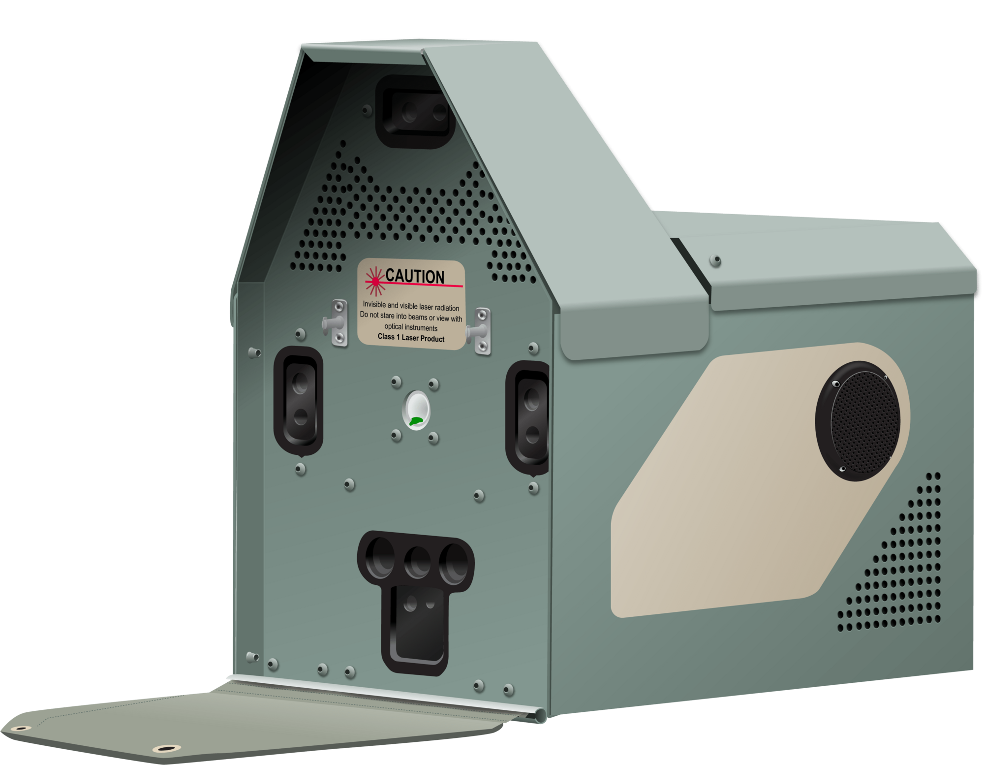
Header image: Shawn F. McCracken
Group curators

- @Nycticebus_scientia
- | he/they
MammalWeb.org
Co-founded citizen science camera-trapping project with interest in developing 100% open source wildlife tech. Advocate for open science/open research. Community member of the Gathering for Open Science Hardware.


- 3 Resources
- 24 Discussions
- 3 Groups
trying to understand and improve the welfare of all animals that can suffer

- 4 Resources
- 6 Discussions
- 7 Groups

- @briannajohns
- | she/they
Gathering for Open Science Hardware (GOSH)
Interested in the application of open source technologies for conservation research.


- 9 Resources
- 4 Discussions
- 4 Groups

- @georg_strunck
- | he/him
Delft University of Technology & SPOTS | Strategic Protection Of Threatened Species
MSc Student in Aerospace/Robotics @TU_Delft | Engineer & Project Manager @StrategicProtectionOfThreatenedSpecies (SPOTS) | Robotics Engineer @BiodivX with @ETH Zürich for the xPrize rainforest competition

- 1 Resources
- 9 Discussions
- 10 Groups
- @KB
- | she/her
Wildlife ecologist specializing in animal movement modeling and habitat selection with a strong interest in conservation policy and management decisions.
- 0 Resources
- 0 Discussions
- 17 Groups

- @TaliaSpeaker
- | She/her
WILDLABS & World Wide Fund for Nature/ World Wildlife Fund (WWF)
I'm the WILDLABS Research Specialist at WWF-US


- 23 Resources
- 62 Discussions
- 25 Groups

WILDLABS & Wildlife Conservation Society (WCS)
I'm the Bioacoustics Research Analyst at WILDLABS. I'm a marine biologist with particular interest in the acoustics behavior of cetaceans. I'm also a backend web developer, hoping to use technology to improve wildlife conservation efforts.


- 27 Resources
- 34 Discussions
- 34 Groups

- @carlybatist
- | she/her
ecoacoustics, biodiversity monitoring, nature tech


- 111 Resources
- 356 Discussions
- 19 Groups
- @himalyanibex
- | He/him
Tech Entrepreneur, ex-Microsoft, ex-Google, believe in technology for greater good, insatiable curiosity towards seeking knowledge & understanding covering disciplines like game theory, mechanism design, economics, ecology, agent-based modeling etc. Hands on with IoT, AI/ML etc.
- 0 Resources
- 2 Discussions
- 5 Groups
Movement ecologist using conservation technology to study the behaviors of animals in the wild and understand how they cope with change to most effectively address conservation- and conflict-related issues.

- 0 Resources
- 9 Discussions
- 11 Groups

Cardiff University
- 0 Resources
- 0 Discussions
- 3 Groups

- @ahmedjunaid
- | He/His
Zoologist, Ecologist, Herpetologist, Conservation Biologist


- 63 Resources
- 7 Discussions
- 26 Groups
Max Planck Institute of Animal Behavior
Project leader of MoveApps | Movement ecology

- 1 Resources
- 5 Discussions
- 5 Groups

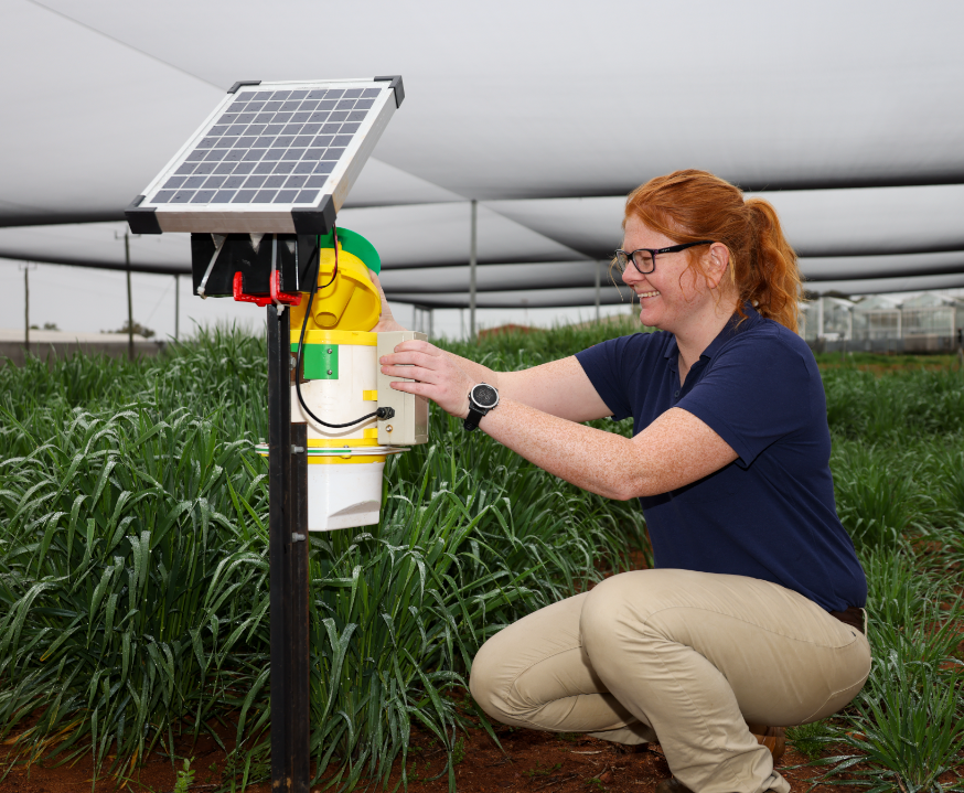
- @amberbc
- | She/Her
The University of Western Australia & WA Department of Primary Industries and Regional Development (DPIRD)
WA Entomology PhD researching better ways to monitor for beneficials. GRDC Research Scholarship. DPIRD Study Leave.
- 6 Resources
- 14 Discussions
- 5 Groups

Cellular Tracking Technologies
Biz Dev at Cellular Tracking Technologies


- 5 Resources
- 73 Discussions
- 4 Groups
Link
Weed-AI: Supporting the AI revolution in weed control

Amber Balfour-Cunningham
Weeds, by definition, are plants in the wrong place but Weed-AI is helping put weed image data in the right place. Weed-AI is an open source, searchable, weeds image data platform designed to facilitate the research and...
7 May 2025
Link
OpenAgTech newsletter: Bringing you the latest in open-source tech for agriculture.
Amber Balfour-Cunningham
Bringing you the latest in open-source technology for agriculture. This accompanies the Open Source Agriculture respository: Collating all open-source datasets, software tools and deployment platforms related to open-...
1 May 2025
Link
Open Source Agriculture Repository
Amber Balfour-Cunningham
Repository for all things open-source in agricultural technology (agritech) development by Guy Coleman. This accompanies the OpenSourceAg newsletter. Aiming to collate all open-source datasets and projects in agtech...
1 May 2025
Article

Fires in Serengeti and Masai Mara National Parks have burned massive areas this year. With Google Earth Engine, it's possible to quantify burn severity using the normalized burn ratio function, then calculate the total...
29 April 2025
Article
Nature Tech for Biodiversity Sector Map launched!

Carly Batist and 1 more
Conservation International is proud to announce the launch of the Nature Tech for Biodiversity Sector Map, developed in partnership with the Nature Tech Collective!
1 April 2025
Article
Modern GIS: Moving from Desktop to Cloud

Vance Russell
Modern GIS is open technology, scalable, and interoperable. How do you implement it? [Header image: kepler.gl]
12 March 2025
Article
Advancing Hierarchical Classification of Ocean Life

Lilli Wakinekona Carlsen
Join the FathomNet Kaggle Competition to show us how you would develop a model that can accurately classify varying taxonomic ranks!
4 March 2025
Article
Last month, we spent four days trekking through Cerro Hoya National Park in Panama, where we hiked from near sea level up to the cloud forest to deploy Mothboxes.
14 February 2025
Link
New paper - "acoupi integrates audio recording, AI-based data processing, data management, and real-time wireless messaging into a unified and configurable framework. We demonstrate the flexibility of acoupi by...
7 February 2025
Article

Over the years, a large number of developments have gone up in the area that I live in and the municipality is not doing what they should when it comes to upholding the laws that have been put in place to protect the...
20 January 2025
Article
Throughout November and December, the Mothbox team has been running field tests in Panama, cleaning up their data for post-processing, and starting an online shop with moth-themed merch!
19 December 2024
Article
Announcement of Project SPARROW

Zhongqi Miao
SPARROW: Solar-Powered Acoustics and Remote Recording Observation Watch
18 December 2024
May 2025

June 2025
event
Nalini
October 2025
event

Lacey Hughey and 3 more
May 2025
event

Pen-Yuan Hsing and 5 more
December 2024
event

Pen-Yuan Hsing and 2 more

September 2024
event

Vanesa Reyes
| Description | Activity | Replies | Groups | Updated |
|---|---|---|---|---|
| The Mothbox team (@briannajohns, @hikinghack, @Hubertszcz, @wellreadpanda, @alex_rogers, @mothyash) is excited to announce that we’ve won a... |
|
Open Source Solutions | 2 hours 37 minutes ago | |
| Hi everyone,What should we share or demo about Software Quality Assurance? Alex Saunders and I, the two Software QA people at Wildlife Protection Solutions (WPS) are going to... |
|
Software Development, AI for Conservation, Open Source Solutions | 3 days 16 hours ago | |
| Interesting. Thanks for the explanation. Nice to hear your passion showing through. |
|
AI for Conservation, Camera Traps, Data management and processing tools, Open Source Solutions, Software Development | 3 weeks 3 days ago | |
| I have posted about this in a different group, but I love boosting the impact of my communication through use of visuals. Free graphics relating to conservation technology... |
|
Geospatial, Climate Change, Community Base, Connectivity, Funding and Finance, Open Source Solutions | 3 weeks 3 days ago | |
| 📸 Do you use camera traps in your work? Take part in our survey!Hi everyone! I’m currently a final-year engineering... |
|
Camera Traps, AI for Conservation, Data management and processing tools, Open Source Solutions, Software Development | 3 weeks 3 days ago | |
| One of our goals with explorer.land is to bridge satellite data and on-the-ground perspectives — helping teams combine field updates,... |
|
AI for Conservation, Geospatial, Open Source Solutions, Sensors | 1 month ago | |
| 15 years ago I had to rebuild the dams on a game reserve I was managing due to flood damage and neglect. How I wished there was an easier,... |
|
Drones, Conservation Tech Training and Education, Data management and processing tools, Emerging Tech, Geospatial, Open Source Solutions | 1 month 1 week ago | |
| Hi, just wanted to let whoever is interested that v.1.3 of DeepFaune is out! Deepfaune is a software that runs on any standard... |
|
Camera Traps, AI for Conservation, Open Source Solutions | 1 month 1 week ago | |
| New stable release : v1.5.1We are pleased to announce the latest release with several important enhancement, fixes and documentation improvements to ensure compatibility with the... |
+15
|
Acoustics, AI for Conservation, Open Source Solutions, Software Development | 1 month 1 week ago | |
| Hello everyone,Thank you all for your contribution!You can read some updates about this project in this post.Julia |
|
Acoustics, Community Base, Data management and processing tools, Open Source Solutions | 1 month 2 weeks ago | |
| Reposting the original post from the GOSH Community:Cool news from the mothbox team! We still don’t have any funding, but our next big goal... |
|
Open Source Solutions, Emerging Tech, Funding and Finance | 1 month 2 weeks ago | |
| Yep see you on friday |
+3
|
Geospatial, Acoustics, AI for Conservation, Camera Traps, Citizen Science, Community Base, Data management and processing tools, Emerging Tech, Open Source Solutions, Protected Area Management Tools | 1 month 3 weeks ago |


Mothbox wins 2025 WILDLABS Award!
22 May 2025 7:55pm
Software QA Topics
9 January 2025 12:00pm
Weed-AI: Supporting the AI revolution in weed control
7 May 2025 10:58pm

Sustainable financing for open source conservation tech - Open Source Solutions + Funding and Finance Community Meeting
Pen-Yuan Hsing
and 5 more
1 May 2025 11:52am
OpenAgTech newsletter: Bringing you the latest in open-source tech for agriculture.
1 May 2025 9:24am

Open Source Agriculture Repository
1 May 2025 9:18am
GitHub - geezacoleman/OpenSourceAgriculture: Collating all open-source datasets, software tools and deployment platforms related to open-source agriculture.
Collating all open-source datasets, software tools and deployment platforms related to open-source agriculture. - geezacoleman/OpenSourceAgriculture

Connecting the Dots: Integrating Animal Movement Data into Global Conservation Frameworks
Lacey Hughey
and 3 more
30 April 2025 1:38am
Fires in the Serengeti: Burn Severity & Remote Sensing with Earth Engine
29 April 2025 6:16pm

1 May 2025 11:44am
No-code custom AI for camera trap images!
25 April 2025 8:33pm

28 April 2025 7:03am
When you process videos, do you not first break them down into a sequence of images and then process the images ? I'm confused as to the distinction between the processing videos versus images here.
28 April 2025 3:57pm
We do, but the way the models handle the images differs depending on whether they're coming from videos or static images. A quick example: videos provide movement information, which can a way of distinguishing between species. We use an implementation of SlowFast for one of our video models that attempts to extract temporal information at different frequencies. If the model has some concept of "these images are time sequenced" it can extract that movement information, whereas if it's a straight image model, that concept doesn't have a place to live. But a straight image model can use more of its capacity for learning e.g. fur patterns, so it can perform better on single images. We did some experimentation along these lines and did find that models trained specifically for images outperformed video models run on single images.
Hope that helps clear up the confusion. Happy to go on and on (and on)...
28 April 2025 5:58pm
Interesting. Thanks for the explanation. Nice to hear your passion showing through.
From Field to Funder: How to communicate impact?
16 April 2025 3:51pm

17 April 2025 5:04pm
Great questions @LeaOpenForests !
I don't have concrete answers since I am not a stakeholder in any project in particular. Based on experience with research on the potential for a similar one-stop-shop for science metrics, I would suggest that there is no simple solution: different actors do need and have different views on presenting and viewing impact. This means possible gaps between what one group of actors need and what the other is willing or able to produce. One can hope, search and aim for sufficient overlap, but I don't see how they would necessarily or naturally overlap.
Still, I would guess that if there are dimensions of overlap, they are time, space and actor-networks
28 April 2025 3:18pm
I have posted about this in a different group, but I love boosting the impact of my communication through use of visuals.
Free graphics relating to conservation technology and the environment are available at:
National Environmental Science Program Graphics Library
Graphics below of a feral cat with a tracking collar and a cat grooming trap are examples of symbols available courtesy of the NESP Resilient Landscapes Hub, nesplandscapes.edu.au.
UMCES Integration and Application Network Media Library
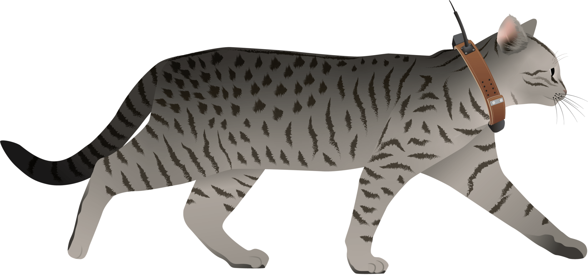
Overview of Image Analysis and Visualization from Camera traps
28 April 2025 8:09am
Ground Truth: How Are You Verifying What Maps Show?
 Léa Smadja
and 1 more
Léa Smadja
and 1 more
16 April 2025 3:35pm
Off-The-Shelf Drones & Open Source GIS Software for Dam Site Surveying?
15 April 2025 3:57pm
DeepFaune v.1.3 is out!

14 April 2025 3:50pm
scikit-maad community

8 August 2024 10:16am

19 February 2025 10:26am
Hello!
I could be wrong, but from looking at the source code of the ACI calculation on the scikit-maad it appears that it autosets j = length of signal. If you want to break it down to e.g. 5 windows you can break the spectrogram into 5 chunks along time and then sum the ACI in each window. This gives a more similar result to the results you got using the other methods. What did you set as nbwindows for seewave?
s, fs = maad.sound.load('test_data_ACI/LINE_2003-10-30_20_00_34.wav')
Sxx, tn, fn, ext = maad.sound.spectrogram (s, fs, mode='amplitude')
full_time = Sxx.shape[1] # number of time samples in spectrogram
j_count = 5 # number of chunks we want to break it into
window_size = np.floor(full_time/j_count) # total time divided by number of chunks = number of time samples per chunk
ACI_tot = 0
for i in range(j_count):
_, _ , ACI = maad.features.acoustic_complexity_index(Sxx[:,int(i*window_size):int(i*window_size+window_size)])
ACI_tot = ACI_tot + int(ACI)
This gives ACI_tot = 1516

6 March 2025 11:07am
Hi all,
I have recently been utilising the ROI module of scikit-maad to locate non-biophonic sounds across low-sample rate Arctic hydrophone datasets and have a query about how ROI centroids are calculated...
Looking at the source code for the function "centroid_features" in .\maad\features\shape.py, I can see that the function calls "center_of_mass" from .\scipy\ndimage\_measurements.py. This to me suggests that the centroid should be placed where energy is focussed, i.e. the middle of the acoustic signature captured by the masking stage of ROI computations.
I'm a bit confused as to why the centroids I have appear to be more or less placed in the centre of the computed ROIs, regardless of the energy distribution within the ROI. The sounds I'm capturing have energy focussed towards lower frequencies of the ROI bands, so I would have expected the centroid to shift downwards as well.
Has anyone modified how ROI centroids are defined in their work? I'd be quite interested to set up centroids to signify where the peak energy level lies in the ROI, but I'm not quite sure how to do this cleanly.
Any advice would be greatly appreciated, thanks!
Kind regards,
Jonathan

11 April 2025 10:08pm
We are pleased to announce the latest release with several important enhancement, fixes and documentation improvements to ensure compatibility with the latest versions of SciPy and scikit-image as well as with Xeno-Canto.
In this new version, 2 new alpha indices are implemented, aROI and nROI, the latter being a good proxy of the average species richness per 1 min soundscape.
Releases · scikit-maad/scikit-maad · GitHub
Open-source and modular toolbox for quantitative soundscape analysis in Python - Releases · scikit-maad/scikit-maad
The boring fund: Standardizing Passive Acoustic Monitoring (PAM) data - Safe & sound
27 January 2025 3:47pm

8 February 2025 11:00pm
This is such an important project! I can't wait to hear about the results.
12 February 2025 4:15pm
Hey Sanne, awesome - we definitely need a consistent metadata standard for PAM.
If you haven't already, I would suggest sharing this on the Conservation Bioacoustics Slack channel and the AI for Conservation Slack channel. You would reach a lot of active users of PAM, including some folks who have worked on similar metadata efforts.
If you're not a member of either one of those, DM me your preferred email address and I'll send you an invite!

7 April 2025 11:07pm
Hello everyone,
Thank you all for your contribution!
You can read some updates about this project in this post.
Julia
Mothbox going to Shenzhen with Seeedstudio
6 April 2025 4:27pm
Nature Tech for Biodiversity Sector Map launched!
Carly Batist
and 1 more
1 April 2025 1:41pm
4 April 2025 1:57pm
Nature Tech Unconference - Anyone attending?
8 March 2025 12:11pm

15 March 2025 8:28am
Definitely!

21 March 2025 12:07pm
The Futures Wild team will be there :)

26 March 2025 7:54pm
Yep see you on friday
Generative AI for simulating landscapes before and after restoration activities

26 March 2025 1:59pm
26 March 2025 7:50pm
Yep we are working on it
#berlin #ia #paysage #naturetech #solutionsfondéessurlanature #greentech… | Olivier Rovellotti 🌍 | 11 comments
🌿 Quand la Technologie Devient L'alliée du Paysagiste 🌍 🎨 Imaginer & Générer Grâce à l’IA générative (Stable Diffusion, Segment Anything), on peut imaginer #Berlin plus verte et tester différents scénarios d’aménagement. Une nouvelle manière d'explorer les possibles, en s’inspirant des principes des plus grands (McHarg, Clément, Burle Marx). 🌳💡 https://lnkd.in/g-uM7d-k 📚 Apprendre Les plateformes comme NBS EduWORLD rendent les solutions fondées sur la nature plus accessibles à tous. https://lnkd.in/gnBTkyN5 🔎 Cartographier & Anticiper Des outils comme ecoTeka permettent d’identifier les espaces à renaturer en croisant données SIG et IA. Cartographie, suivi des arbres, calcul des services écosystémiques… https://lnkd.in/daTBxbwn 🔗 Réfléchir: Dans "Harnessing generative AI to support nature-based solutions", Sandra Lavorel et Al nous donne des pistes d'explorations pour aller plus loin https://lnkd.in/gSH6Au9s 💬 Et vous ? 🌱🤖 #IA #Paysage #NatureTech #SolutionsFondéesSurLaNature #GreenTech #Biodiversité #NBSEduWorld #FosterTheFuture #TeachFromNature #NatureBasedSolutions #ClimateChange #STEM | 11 comments on LinkedIn

1/ segment
2/remote unwanted ecosytem
3/get local potential habitat
4/generate
5/add to picture
United Nations Open Source Principles
13 March 2025 4:13pm
25 March 2025 11:54am
All sound, would be nice if there were only 5, though!
Drone Photogrammetry & GIS Introduction (Foundation) Course
 Sean Hill
and 1 more
Sean Hill
and 1 more
18 March 2025 12:47pm
Modern GIS: Moving from Desktop to Cloud
12 March 2025 7:10pm
Nature FIRST Conference: Innovation and Collaboration in Conservation
11 March 2025 9:39am
Presenters wanted: showcase your open source income streams
 Frank van der Most
and 5 more
Frank van der Most
and 5 more
17 February 2025 2:08pm
7 March 2025 12:06am
Thanks for your interest and sharing potential candidates, Vance!
7 March 2025 12:14am
Thank you for your interest @Alasdair !
7 March 2025 12:21am
It's great to see so much interest in presenting at this webinar. We have also received interest through direct messages and meetings that we've happened to have had. Thank you all for volunteering!
We will get back to you after wext week Wednesday ( 12th ) when there will be the next coordination meeting.
This date will also be the deadline for those still considering to volunteer.
Advancing Hierarchical Classification of Ocean Life
4 March 2025 10:09pm

4 March 2025 10:13pm
What are open source solutions anyway?
1 November 2024 2:21pm
11 December 2024 12:34pm
Open source technologies are a game-changer for biodiversity conservation. They give us the freedom to use, study, modify, and share vital tools and knowledge that help advance research in meaningful ways. For conservationists, this means we can adapt technologies to meet local needs, improve existing tools, and make new innovations available to everyone—creating a more collaborative and sustainable future for our planet.
It’s exciting to see the impact of open source in conservation already, with tools like Mothbox, Fieldkit, and OpenCTD helping to drive progress. I'm curious—how do the formal definitions of open source resonate with you? How do they shape the way we approach conservation?
Also, if you're interested in how open source AI can support conservation efforts, check out this article: Open Source AI Agents: How to Use Them and Best Examples.
Can’t wait to hear your thoughts! Let's keep the conversation going.
11 December 2024 9:04pm
Sorry to be a stickler on syntax when there is a richer discussion about community here - but I believe a true "open source" project is a functionally complete reference design that anyone can build upon with no strings attached. If the community isn’t provided with enough information to fully build and iterate on the design independently, then the project doesn’t truly meet the spirit of open source.
As a developer and engineer, I’ve observed that sometimes projects crowdsource free engineering work under the guise of being "open source." While this can have benefits, it can feel like asking for a free lunch from clients and customers.
Advanced features—like enterprise-level data management or tools for large-scale deployments—can reasonably remain proprietary to sustain the project financially. Transparency is critical here. If the foundational components aren’t fully open, it would be more accurate to describe the project as "community-driven" or "partially open." And as an engineer/developer I wouldn't be angry when I went to explore the project marked "open source" only to find that I have been lied to.
Just my two cents, and I really appreciate the thoughtful discussion here. The open source community has been a massive influence on me. Everything I do at work would not be possible without it. In many ways, "open source" or "public domain" projects represents the true know-how of our society.
4 March 2025 3:27pm
Thanks again for the interesting discussion everyone!
Just a note that while I touched on it in my opening post above, there were still questions in this thread about what open source tech means. I tried to address that in my new thread here:
Definitions for open source software & hardware and why they're important
27 February 2025 10:58am
28 February 2025 5:26pm
Thanks for this excellent and thought-provoking post, Pen. I agree this is a binary yes/no issue, but there is a spectrum. There could also be philosophical nuances. For example, does excluding honey from a vegan diet meet the ethical criteria of veganism? It's an animal product, so yes, but beekeeping generally doesn't have the same exploitative potential as cow, sheep, or pig husbandry, right? However, looking strictly at the definition, honey is out if you want to be vegan.
Back to software! Isn’t the main issue that companies falsely claim to offer open source hardware/software? To avoid this, do you then have to create an accreditation system? Who polices it? Is it fair? Would users care that their software has the accredited open source stamp of approval? Ultimately, we need definitions to define boundaries and speak a common language.
4 March 2025 3:21pm
Thanks @VAR1 great insights! Funny you mentioned the honey thing, @hikinghack said the same in response on the GOSH forum.
I think the point I'm trying to make with the vegan comparison is that while it might not be 100%, it is close enough for us to have productive conversations about it without running in circles because we can't even agree on what we are talking about.
As for open source tech, there actually is accreditation for open source hardware (at least of a sort). The Open Source Hardware Association has a fairly mature certificate program:
OSHWA Certification
Certification provides an easy and straightforward way for producers to indicate that their products meet a well-defined standard for open-source compliance.
I am genuinely undecided whether such a formal accreditation system is required for open source software. My undecided-ness comes back to the food/agriculture analogy, where a similar issue exists for organic certification. Being certified organic could possibly, in some cases, be beneficial. However, certification can also be very onerous for small organic farmers who can't afford to get it.
But before we even think about accreditation, I echo your last sentence that we need definitions to define boundaries. These definitions, as I argue in my original post above, is not only about principles and philosophy, they are also a practical necessity for enabling effective communication!
GPS Tracker For Wildlife
27 February 2025 12:13pm

2 March 2025 11:34am
Thank you for this valuable information!
Some of the features you mentioned can be quickly added to Loko, while others require more consideration. Loko’s communication is one-way—meaning the transmitter doesn’t know whether the receiver has received the data. This design choice is made to conserve battery life. However, all data is logged internally and can be accessed via USB.
I will add GeoTIFF loading to the Loko App. Currently, Loko is not suitable for wildlife tracking because it is not waterproof, but I am working on improving its mechanical design.
Loko already supports multiple connections, allowing many transmitters to connect to a single receiver or/and multiple receivers.
Regarding encryption: What do you mean by "Encryption should not be optional"?
Are you suggesting that communication should always be encrypted by default? on loko I made it user-configurable because encrypted data packets are 32 bytes, whereas unencrypted ones are 18 bytes. A smaller data packet improves reception sensitivity and extends the transmission range.
In your opinion, what would be a reasonable price for such a device? This is very important when adding new hardware features.
Cheers,
Akio)
2 March 2025 11:42am
Hi Herhanu , appreciate for your valuable feedbacks.
- can you explain what type of release mechanisim do you mean , picture will be much helpfull . do you mean with a remote release mechanisim activates and release the tracker from crocodile collar?
- how far data need to be sent ? with a mesh network of Loko receivers wide range of area can be covered i guess.
- long distance transmission is very challanging when transmitter is very close the ground , on crocodiles especially.
for what purpose do would you use accelerometer data? is there any specific use case?
Cheers, )

2 March 2025 11:55pm
Sure, Akio! Happy to answer!
1. Yes, something like that. The few existing i guess applied already for GPS collar (literally collar) that usually for big cats and some other big mammals. There is also GPS tag for Cetaceans that can pop up, but its only remained with the animals several days CMIIW (eg see links below)
link 1
2. I guess it depends on your research questions or project objectives. But for crocodile they can have vast home range from 100 ha to 10,000 ha (depends on species). For my species, it at least uses 500 ha of area, and the farthest between points can be 15km apart.
3. accelerometer, especially in crocodile can give insight about their movement ability. As they can random as they can be - or being a statue for hours (like when you look at crocs in the zoo). Of course this would depends on your objectives.
Hope this helps!
Cheers~
How much does it cost to incorporate Machine Learning into your drone GIS analysis process?
28 February 2025 8:44am
19 May 2025 5:30am
Sounds like a great initiative—looking forward to it! I’d love to hear more about your real-world test automation setup, especially any tools or frameworks you’ve found effective at WPS. It’d also be helpful to see how QA fits into your dev workflow and any challenges you’ve faced specific to conservation tech. I just filled out the poll and can’t wait to see what topics get chosen. Thanks, Alex and team, for organizing this!