This group is home to the protected area management tools that bring data collection, analysis, and reporting together to enable frontline conservation work in real-time. These integrated systems include many tools and topics related to other community groups, so if you're interested in this space make sure to check out our Sensors and Connectivity groups as well.
Resources for Getting Started:
- Watch the recording of our virtual meetup on Networked Sensors for Security and Human-Wildlife Conflict Prevention, including talks from WWF, SmartParks, and Sensing Clues.
- Check out this Introduction to SMART on our YouTube channel.
- Hear about the work Wildlife Protection Solutions is doing in this space.
- Watch Ted Schmidt's lunchtime lecture on Tech Readiness and Protected Area Management Tools.
- For a marine perspective, watch Max Schofield's Tech Tutors episode: How do I use open access remote sensing data to monitor fishing?
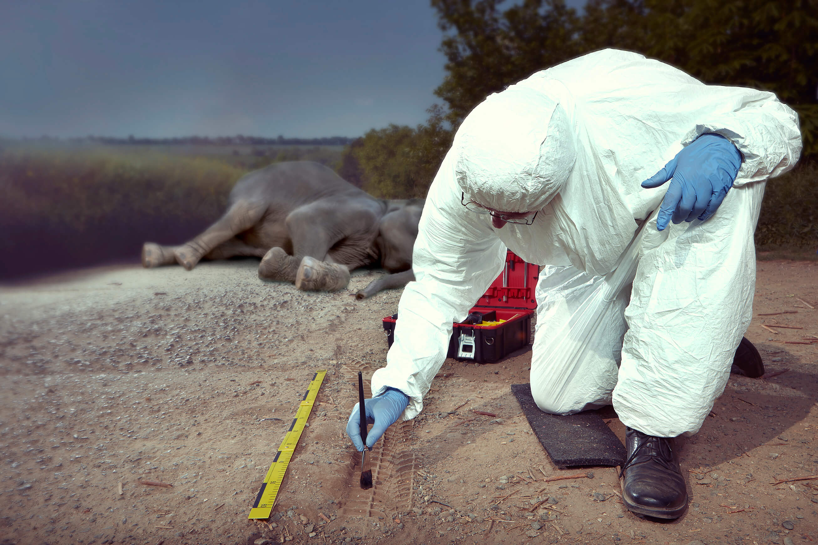
Header image: Save the Elephants
- @KB
- | she/her
Wildlife ecologist specializing in animal movement modeling and habitat selection with a strong interest in conservation policy and management decisions.
- 0 Resources
- 0 Discussions
- 17 Groups

WILDLABS & Wildlife Conservation Society (WCS)
I'm the Bioacoustics Research Analyst at WILDLABS. I'm a marine biologist with particular interest in the acoustics behavior of cetaceans. I'm also a backend web developer, hoping to use technology to improve wildlife conservation efforts.


- 27 Resources
- 34 Discussions
- 34 Groups

Sustainability Manager for CERES Tag LTD. An animal health company; animal monitoring, conservation, & anti-poaching/ rural crime. Wildlife, livestock, equine & companion. #CeresTrace #CeresWild #CeresRanch


- 2 Resources
- 20 Discussions
- 24 Groups

- @ahmedjunaid
- | He/His
Zoologist, Ecologist, Herpetologist, Conservation Biologist


- 63 Resources
- 7 Discussions
- 26 Groups

- @Robincrocs
- | He/Him//El//Ele
Wildlife biologist, works with Caimans and Crocodiles
- 0 Resources
- 0 Discussions
- 15 Groups
Instituto Humboldt
Ingeniera Ambiental apasionada por el mapeo. Aprendiz de uso y pilotaje de drones . Investigadora de Biodiversidad, desde el énfasis de ecología e paisaje y monitoreo.
- 0 Resources
- 0 Discussions
- 2 Groups
- @HeinrichS
- | he/him
Conservation tech geek, custodian (some say owner) and passionate protector of African wildlife, business systems analyst.

- 0 Resources
- 29 Discussions
- 6 Groups

- @StephODonnell
- | She / Her


- 193 Resources
- 676 Discussions
- 32 Groups

2023 Bachelor Degree Graduate from the College of African Wildlife Management, Mweka.

- 0 Resources
- 3 Discussions
- 14 Groups

- @georg_strunck
- | he/him
Delft University of Technology & SPOTS | Strategic Protection Of Threatened Species
MSc Student in Aerospace/Robotics @TU_Delft | Engineer & Project Manager @StrategicProtectionOfThreatenedSpecies (SPOTS) | Robotics Engineer @BiodivX with @ETH Zürich for the xPrize rainforest competition
- 1 Resources
- 9 Discussions
- 10 Groups

- @roxirisa
- | roxi
Biologist I consider myself a data scientist with a passion for nature and with an extensive experience in species distribution modeling, handling large data sets from different sources such as gbif, eBird, xeno-canto, Worldclim, Terraclimate, ocean color e NASA among others. But
- 0 Resources
- 0 Discussions
- 9 Groups
- @a.zubiria
- | she/her
- 0 Resources
- 2 Discussions
- 11 Groups
Careers
SMART Partnership Director

Richard Bergl
The SMART Partnership is hiring a Program Director to oversee all aspects of the partnership's operations
21 February 2024
Article

Here are a few key insights from this year's event that we're carrying into 2024.
2 January 2024
Article
Paving the Way for Women: LoRaWAN Technology in Akagera National Park with Clementine Uwamahoro

Esther Githinji and 1 more
Read our interview with Clementine Uwamahoro, African Parks’ Country Manager in Conservation Technology overlooking technology operations for both Akagera National Park and Nyungwe National Park.
29 November 2023
Article
ICOTEQ launch TAGRANGER® system of products
Craig Rackstraw
TagRanger® is a state-of-the-art wildlife finding, monitoring and tracking solution for research, conservation and environmental professionals. With superior configurability for logging data, reporting location and...
23 November 2023
Link
Defenders unveiled WALT: Wildlife & Land Trusts, an interactive tool empowering land trusts to conserve more land by making accessible the necessary information for funding & technical assistance.
20 November 2023
Link
A secure platform designed for those working to monitor & protect natural resources. Insight facilitates sharing experience, knowledge & tools to increase efficiency & effectiveness in conservation. By...
7 November 2023
Article
The illegal wildlife trade varies widely regarding species and geographical variance, necessitating niche and tailored research. Against this background, this study on elephant poaching in Tanzania was conducted at the...
30 October 2023
Article
With the rising threats to biodiversity such as wildlife crime, climate change and human-wildlife conflict today, wildlife monitoring technologies have become vital to study movement ecology, behaviour patterns, changes...
25 October 2023
Article
We're delighted to announce that Connected Conservation Foundation and Airbus Foundation have today launched round 2 of the ‘Satellites for Biodiversity Award’.
2 October 2023
Careers
GIS & Data Science Specialist
Emma Oldham
Could you be our next team member to help empower conservation through data and technology?
28 September 2023
Article

The partnership will support the Global South with the development, planning and management of marine protected areas (MPAs) in the high seas.
22 September 2023
Careers
Conservation Technology Specialist

Wildlife Conservation Society (WCS)
WCS is seeking a Conservation Technology Specialist to join their work in the Okapi Wildlife Reserve.
11 August 2023
October 2024

9 Products
Recently updated products
| Description | Activity | Replies | Groups | Updated |
|---|---|---|---|---|
| The European project Nature FIRST is hosting its final conference at Ouwehands Dierenpark in the Netherlands on 25–26 June 2025,... |
|
Community Base, Conservation Tech Training and Education, Data management and processing tools, Earth Observation 101 Community, Emerging Tech, Human-Wildlife Conflict, Protected Area Management Tools, Wildlife Crime | 5 hours 18 minutes ago | |
| My name is Frank Short and I am a PhD Candidate at Boston University in Biological Anthropology. I am currently doing fieldwork in Indonesia using machine-learning powered passive... |
|
Acoustics, AI for Conservation, Animal Movement, Data management and processing tools, Early Career, Emerging Tech, Ethics of Conservation Tech, Protected Area Management Tools, Software Development | 2 weeks ago | |
| Hi @iainmcnicol , welcome to WILDLABS! Thanks for posting this on here. I have shared with my colleagues at Fauna & Flora who have some experience (especially with the... |
|
Community Base, Geospatial, Protected Area Management Tools, Wildlife Crime | 1 month 1 week ago | |
| Hi Ryan, hmm, I had no idea there was a microphone named that. I thought about how it’s used to lure birds for netting, and I like Greek Mythology. I thought it was a perfect fit... |
|
Acoustics, Emerging Tech, Funding and Finance, Protected Area Management Tools, Software Development | 1 month 2 weeks ago | |
| Yep see you on friday |
+3
|
Geospatial, Acoustics, AI for Conservation, Camera Traps, Citizen Science, Community Base, Data management and processing tools, Emerging Tech, Open Source Solutions, Protected Area Management Tools | 1 month 3 weeks ago | |
| Hi Simon,We (Reneco International Wildlife Consultants) have an ongoing collaboration with a local University (Abu Dhabi, UAE) for developing AI tools (cameratrap/drone... |
|
Acoustics, AI for Conservation, Animal Movement, Camera Traps, Citizen Science, Connectivity, Drones, Early Career, eDNA & Genomics, Marine Conservation, Protected Area Management Tools, Sensors | 4 months 1 week ago | |
| Thank you David, a phenomenal source! |
+10
|
Drones, Geospatial, Protected Area Management Tools | 4 months 2 weeks ago | |
| Hi Matthew Wow, what an amazing project! It is incredible how you have managed to figure out some of the complexities of combining underwater imagery with UAV imagery. I am... |
|
Drones, Geospatial, Marine Conservation, Protected Area Management Tools | 5 months ago | |
| About the Centre for Sustainable Forests and Landscapes (CSFL)Galvanising research and teaching to deliver... |
|
Community Base, Climate Change, Conservation Tech Training and Education, Funding and Finance, Protected Area Management Tools | 6 months ago | |
| Hi Brett, I am interested in developing really low cost multi channel underwater acoustic recorders. Can you tell me a bit more about the board and stuff you were using... |
|
Build Your Own Data Logger Community, Acoustics, Camera Traps, Climate Change, East Africa Community, Marine Conservation, Open Source Solutions, Protected Area Management Tools | 7 months ago | |
| Thanks, we know they are breeding these animals here, I asked, since it's seems to be an expensive hobby, we need to allocate more funding for rural women in entrepreneurship and... |
|
Acoustics, Animal Movement, Citizen Science, Human-Wildlife Conflict, Protected Area Management Tools, Wildlife Crime | 7 months 1 week ago | |
| Who should evaluate (criteria/ questions assessment and scoring) ? - the Park Staff or the NGOs working in the Park or the Independent... |
|
Protected Area Management Tools | 8 months ago |


Apply for Free Access to Nature FIRST Conference (innovative solutions for biodiversity monitoring and human-wildlife coexistence)
22 May 2025 2:37pm
Prospective NSF INTERN
11 February 2025 10:00am
Evaluation of Global Forest Watch
17 March 2025 4:51pm

9 April 2025 8:05pm
Hi @iainmcnicol , welcome to WILDLABS! Thanks for posting this on here. I have shared with my colleagues at Fauna & Flora who have some experience (especially with the deforestation alerts) and could maybe provide feedback as well. We also have a page on 'The Inventory' where we're asking people to review various data products, tools, platforms etc including one for Global Forest Watch. As you can see not many reviews currently so it would be great (if possible by anonymising responses etc.) to get the information from your survey and translate this into something we could add to 'The Inventory' for the wider community. Let me know your thoughts on this!
Also is there a closing date for the survey?
Field-Ready Bioacoustics System in Field Testing
2 April 2025 10:38am

3 April 2025 3:38pm
Hi Carly,
Thanks so much for your thoughtful message—and for introducing me to Freaklabs! BoomBox looks awesome, and it’s exciting to see how closely our goals align. There’s definitely potential for collaboration, and I’d be happy to chat more. Their system is super efficient and I think both of our systems have a place in this space.
Affordability and reliability were key considerations when I started building Orpheus. I wanted to create something rugged enough to survive in the field year-round while still being accessible for conservationists with limited budgets. The full-featured unit is €1500, and the basic model is €800. That pricing reflects both the hardware and the considerable time I’ve spent writing and refining the system—it’s all about balancing performance, durability, and keeping it sustainable for the long term.
Even the base unit is more than just a playback device. It logs every playback event, duration, and species, with enough onboard storage for two years of data, and it automatically converts the logs to line protocol for easy integration into platforms like InfluxDB.
On top of that, Orpheus actively logs and graphs temperature, humidity, atmospheric pressure, and battery voltage. During deep sleep, it interpolates the environmental data to preserve meaningful trends without wasting energy. You can view any of these on it's 5" touch screen or view it in the cross-platform app that will support both Android and IOS once I'm done programming it.
As for audio specs:
- Recording is supported up to 96kHz,
- Playback is full 24-bit, both MP3 and WAV formats
- The system currently supports recording audio clips, reviewing them, and even adding those clips directly to playlists on the device.
That said, for bat research, I know ultrasonic capability is essential. While the current hardware doesn’t capture over 100kHz, I’ve already done the research and identified alternative audio interfaces that would support that range. If that’s a need researchers are interested in, I’d be open to building out a dedicated version to meet those requirements.
Power-wise, it runs indefinitely on solar, even under partly cloudy conditions. It uses a LiFePO₄ battery, and depending on usage, it can operate for up to two weeks on battery alone. It also supports external power from 12V or 24V systems, and solar input from 12V to 70V, so it’s pretty adaptable to various field setups. it also can operate from -5 to 70C (still testing that), but the hardware should be capable according to specs. Your correct though in places like the rain forest that could be challenging and an alternative would need to be considered.
The software is written modularly to allow for expansion based on user needs. For instance, I’ve already integrated support for a rain sensor that can pause playback if the user chooses that, and could easily include PIR, microwave, or other sensors for more specialized triggers.
Regarding durability, I’m currently testing mesh cable sheathing to deter rodents and other wildlife from chewing the wires—this was a concern raised by one of the teams using Orpheus, and I’m designing around it.
Also, Orpheus includes a seasonal scheduling engine—you can define your own seasons (like Migration, Breeding, etc.) and assign unique playback playlists to each. The device uses astronomical data (sunrise/sunset) based on your provided lat/lon and time zone, and automatically adjusts timing offsets like “1 hour before sunrise.” The goal is truly fire-and-forget deployment.
I'm open to adding any features or sensors that might be useful within reason.
I’m curious though, what specs would make a recording device for bats an indispensable tool? What features don’t already exist on the market that should?
Warm regards,
Travis

5 April 2025 4:03pm
I love the look of the system! We almost called our new sensor Orpheus, but decided against it as there is already a microphone named that! I'd love to see a bit more about the technical implementation! Is this running off of a CM5 or something different?
6 April 2025 1:45pm
Hi Ryan, hmm, I had no idea there was a microphone named that. I thought about how it’s used to lure birds for netting, and I like Greek Mythology. I thought it was a perfect fit, but hmm, May have to change the name. I considered using a CM, but i wanted the system to be as efficient as possible. I am using a RPI Zero 2 W with emmc. To ensure the UI stays responsive I used some backend tricks like thread pooling. It works well and resources stay in check. The challenging part is ensuring thread handling is done gracefully and carefully to prevent race conditions. What sort of sensor have you been developing?
Nature Tech for Biodiversity Sector Map launched!
 Carly Batist
and 1 more
Carly Batist
and 1 more
1 April 2025 1:41pm

4 April 2025 1:57pm
Nature Tech Unconference - Anyone attending?
8 March 2025 12:11pm
15 March 2025 8:28am
Definitely!

21 March 2025 12:07pm
The Futures Wild team will be there :)

26 March 2025 7:54pm
Yep see you on friday
Tropical fieldwork funding! Up to $15,000 -Susan Wojcicki Fellowship
10 February 2025 7:01pm
Collaring Elephants and Post Release Monitoring
28 January 2025 3:16pm
collaring elephants and post-release monitoring
In Post Release Monitoring (the monitoring of animals after release back into the wild), the invaluable insights that we gain from GPS-enabled collars help us to:

Can/Should UAVs Be The Answer To Urbanisation & Wildlife Conflicts
20 January 2025 11:00am
Thesis Collaboration
4 January 2025 5:15pm

7 January 2025 12:32pm
Hi Simon,
Did you already contact INBO? Both biologging and citizen science are big themes at INBO. Last year we had a master thesis on camera trapping invasive muntjac. You can send me a private message for more info!

14 January 2025 3:30pm
Hi Simon,
We're a biologging start-up based in Antwerp and are definitely open to collaborate if you're interested. We've got some programs going on with local zoo's. Feel free to send me a DM if you'd like to know more.
15 January 2025 8:30am
Hi Simon,
We (Reneco International Wildlife Consultants) have an ongoing collaboration with a local University (Abu Dhabi, UAE) for developing AI tools (cameratrap/drone images and video analyses) and biomimetic robots applied to conservation (e.g https://www.sciencedirect.com/science/article/pii/S1574954124004813 ). We also have a genetic team working on eDNA. Field experience could be possible, in UAE or Morocco.
Feel free to write me back if you may be interested and would like to know more
Recommended Hardware to stitch together Drone Imagery into Orthomosaics
25 November 2024 6:25am
21 December 2024 5:21am
This site may be of use for WebODM and photogrammetry using UAVs, as it focuses purely on processing that type of data and the hardware required. It also covers Conservation and Agriculture analysis and training using open source GIS and 3D point cloud software. Follow the links below:
https://www.geowingacademy.com
Hope this helps.

3 January 2025 3:41am
Hi @willrippon, I've worked with 3D reconstruction systems (software and hardware) for over 10 years now, and lately I've been really pleasantly surprised by Pix4D.
Here is a demo for a landscape survey my company just did.
Here is a 300 MB orthomosaic we just got as well.
Here is the hardware workflow described in detail.
On top of the drone imagery, we did "post-processing kinematics" (PPK) of the drone images (a very important thing to do, otherwise photogrammetry quality really suffers). I'm happy to discuss workflow further, and plan to release open source code and services.
If nothing else, go with Pix4D.

6 January 2025 7:40am
Thank you David, a phenomenal source!
Photogrammetry of Coral Reef Breakwaters
20 December 2024 1:11am

22 December 2024 8:35am
Hi Matthew
Wow, what an amazing project! It is incredible how you have managed to figure out some of the complexities of combining underwater imagery with UAV imagery. I am sure that was a fascinating learning experience.
I cannot help you with Points 1 and 3 but can suggest using Orfeo Toolbox for your segmentation process in Point 2. It integrates with QGIS and is open source. It will work with your UAV ortho maps if there is enough visible detail of the corals. You will be able to build and train your own model in order to accurately segment you reef. It takes a bit of know how to us the Machine Learning algorithms but once you get the hang of it it becomes immensely powerful. I will be building an online course on how to build your own machine learning processing algorithms in 2025 using this brilliant package. Once segmented you can save out the shapefiles and use them to segment and define your 3D point clouds in Agisoft.
Alternatively, look into using Picterra Geospatial AI. It is cloud based and much simpler to use but you may need to compress your imagery or point clouds in order to upload them given the file size you mentioned above. (Although they probable do allow for large uploads these days, I used Picterra in the past and it was brilliant!). Also i am not sure if it works with point clouds directly but have a look
I hope this helps. Great project!
Discover the Centre for Sustainable Forests and Landscapes (CSFL) in Edinburgh
18 November 2024 9:37am
Recycled & DIY Remote Monitoring Buoy
15 January 2024 1:14am
3 October 2024 9:16am
Hi Brett,this ocean lab sychelles is great to hear from you! I love your remote monitoring buoy project, especially the recycling of DFAD buoys and the design of custom-built ones that are full of interesting features. The expandability of the navigation buoys enabling it to be configured as hydrophones, cameras, or water quality monitors is a great feature. The technical marvels, such as recycling DFADs' circuits, making your own hydrophone, and designing a super-efficient system, are terrific. Moreover, it is encouraging to witness the deployment of your early system, particularly the live video and water quality data you have collected. You will definitely make a positive impact on the Wildlabs community with your knowledge of electrical engineering and software development. I care to hear more of your discoveries and any news that you will be sharing. Keep doing what you excel at!

8 October 2024 8:46am
Thank you for sharing!
21 October 2024 12:45am
Hi Brett,
I am interested in developing really low cost multi channel underwater acoustic recorders. Can you tell me a bit more about the board and stuff you were using for yours? You can get me at chris@wilcoanalytics.org.
Thanks,
Chris
Roe deer protection needed in Hungary, national government should stop funding hunting organizations - call for international support
7 October 2024 11:58am

14 October 2024 12:41pm
Really? Can you share where its written.
Annex III: protected fauna species, do you need a glass?

14 October 2024 1:33pm
A quick search comes up with the following answer. Let us know if that helps.
Annex III of the European Environmental Agency (EEA) does not directly regulate the protection or hunting of specific species. Instead, it's important to look at Annexes II and IVof the EU Habitats Directive (Directive 92/43/EEC) for species protection and hunting regulations in the European Union.
Roe deer (Capreolus capreolus) is not listed in Annex IV (which covers strictly protected species), meaning it is not afforded the strictest protection that prevents all forms of exploitation. However, Annex III of the Bern Convention, which relates to species that may be exploited but require careful regulation, includes species like roe deer.
In many European countries, roe deer hunting is permitted under specific regulated conditions. These regulations aim to ensure sustainable hunting practices and maintain healthy population levels, with hunting seasons and quotas determined based on local wildlife management policies.
In summary, roe deer are generally not strictly protected across the EU, and hunting is allowed under regulation, though specific conditions depend on national and regional legislation.
Disclaimer: I can't guarantee that the above is not a hallucination :-)
15 October 2024 11:24am
Thanks, we know they are breeding these animals here, I asked, since it's seems to be an expensive hobby, we need to allocate more funding for rural women in entrepreneurship and access to technologies, reduce poverty in Hungary No1 priority.
That's the problem local peoples can not afford buying wild meat from the "local shop"
Fully uncontrolled activites in Hungary
MS and PhD Opportunities in Ocean Engineering and Oceanography

6 October 2024 9:44am
Calling for applications for Round 3 of our Satellites for Biodiversity Award Grant
30 September 2024 5:22pm
Design-led innovation for nature
20 September 2024 2:24pm
METT4 Evaluation
16 September 2024 5:28am
Global model for Livestock detection in airborne imagery - Data, Applications, and Needs
12 August 2024 8:19pm
4 September 2024 6:15pm
It looks like the website has not been updated since 2022 and indeed you need to register. If you go under 'Manage Account' you may be able to register. I tried to register but I got an error saying 'Login failed! Account is not active'. I got an email saying "Your account must be approved before being activated. Once your account has been approved, you will be notified." So I am waiting for the account to be approved...
I'll keep you posted

6 September 2024 12:46pm
Hi Ben!
Great initiative!
A review of deep learning techniques for detecting animals in aerial and satellite images
https://www.sciencedirect.com/science/article/pii/S1569843224000864#b0475
lists a number of data sets (incl. one published by you it seems...)
Also, @dmorris keeps a list of Terrestrial wild animal images (aerial/drone):
https://lila.science/otherdatasets#images-terrestrial-animals-drone
List of other conservation data sets - LILA BC
LILA BC - List of other conservation-related data sets

which seem like it might be useful for you.

9 September 2024 8:10pm
Hi @benweinstein !
- Surely a general detector might be very useful for detecting objects in aerial imagery! Maybe something similar to what MegaDetector does in camera trap images, generally detecting person, animal, and vehicle (and thus also empty photos). This could greatly improve semi-automated procedures. It could also serve as a first step for context-specific detectors or classifiers to be developed on top of this general one.
- There is also the WAID dataset that is readily available. Our research group could also provide images containing cows, sheep, and deer from South America.
Best
WILDLABS AWARDS 2024 - FinDrop: Accessible Acoustic Monitoring for Mesophotic Marine Environments
5 April 2024 10:22pm

10 August 2024 6:47am
This opportunity is what got me started in deep reef fishes! The grant is for predoctoral students and is due September 30, 2024!! Happy to help or collaborate with anyone interested :)
Eligibility: STRI seeks a diversity of applicants and encourages students from institutions throughout the neotropics to apply. Awards are based upon merit, without regard to race, color, religion, sex, national origin, citizenship, age or condition of handicap of the applicant.

23 August 2024 1:58pm
Really great project @MattyD797 and team. Looking forward to seeing your progress. What is the target price of the FinDrop?
27 August 2024 5:40am
Hey Xavier!
Thank you for your interest and question!!
The overarching goal of the FinDrop v1 for the WildLabs award is to characterize an instrument and make it as, if not more, sensitive than a ST600 Ocean acoustic instrument at a fraction of the price. While I can’t at this stage provide an accurate estimate of final price, it will be a substantial price decrease over an ST600 while providing the same duration and depth expectations. That decrease in price does exponentially decrease with the number we can expect to sell/interest and may increase with additional features the beta testers suggest.
This award only gets us to the actual building of the prototype v1 by December, but we are already scheduled to have a completed product v2 built by March/April through additional collaborations that will be manufactured and sold through Sexton Underwater Housing Co.
Please let me know if you have any other questions!
WCS Conservation Technology Webinar Series
23 August 2024 3:20pm

23 August 2024 7:04pm
23 August 2024 8:30pm
The need for specialized technology tools to enhance plant conservation
3 August 2024 8:31pm
11 August 2024 1:21am
That's a great question! I don't have any answers but my first thought was that the detection part of the problem looks very different when you're looking for plants vs animals (no camera traps, audio recorders, etc.) and often quite hard, as you're having to discriminate species that may be difficult to identify even in hand.
I'd love to hear more from people who are working on this!

11 August 2024 7:07am
Thank you for your valuable insights. I, too, am eager to hear more from those actively working on this issue.
Exploring the Potential of Synthetic Aperture Radar for Plant Conservation
3 August 2024 9:14pm
Understanding the Application of SMART in Measuring Law Enforcement Performance in Protected Areas.
22 July 2024 2:25pm
24 July 2024 6:30pm
Thank you very much Carly Batist for the suggestion! I haven't reached out to the SMART folks yet, but I will. Getting contacts and case studies from them sounds very helpful to me.
24 July 2024 6:40pm
Also thanks for letting me know about Lilyxu and others you mentioned, i will reach out to them.

31 July 2024 6:33pm
Keep digging Sarah!!
Move BON Development: Follow up discussion

19 June 2024 12:02pm

11 July 2024 10:14pm
You can catch up on the recording at that same link to the June Variety Hour! Lacey's fabulous talk starts around the 9:40 mark :)

12 July 2024 5:38am
Hi Talia!
I feel like the topic is so broad that it might help to put some constraints around things, see what works, and then broaden those out. I have a lot of ideas regarding the data monitoring and collection side based on the other sensor and observation networks we've set up in the past.
There may also be some potential scope to incorporate things like data collection and integrated monitoring to the Build Your Own Datalogger series where the system is updated to feed data into the observation network.
It'd probably take a bit of discussion and coordination. Let me know if interested. I'm fine to jump on a call or discuss via email too.
22 July 2024 9:24pm
@cmwainaina please take a look
Enter to win a free thermal camera!

26 June 2024 5:38pm
NEW PUBLICATION ALERT!

17 June 2024 11:33am

17 June 2024 12:57pm
17 June 2024 7:40pm
Fauna & Flora: Bridging geospatial data and people together for enhanced conservation management

17 April 2024 11:31am
13 June 2024 8:51pm
This is amazing! Thank you for sharing. I'm speaking on this topic at the National Center for Ecological Analysis and Synthesis in October. If you have any other resources on this topic, let me know! Closing the loop for "Science to Action" is a huge part of the work we do so I'm always looking to learn.
16 June 2024 3:32pm
Tagging @Chelsea_Smith so she sees this :)
Conservation Technology for Human-Wildlife Conflict in Non-Protected Areas: Advice on Generating Evidence
22 January 2024 11:36pm

4 February 2024 8:16am
Hi Amit,
The most important thing is that the livestock owners contact you as soon as possible after finding the carcass. We commonly do two things if they contact us on the same day or just after the livestock was killed:
- Use CyberTracker (or similar software) on an Android smart phone to record all tracks, bite marks, feeding pattern and any other relevant signs of the reason for the loss with pictures and GPS coordinates. [BTW, Compensation is a big issue -- What do you do if the livestock was stolen? What do you do if a domestic animal killed the livestock? What if it died from disease or natural causes and was scavenged upon by carnivores afterwards?]
- In the case of most cats, they would hide the prey (or just mark it by covering it with grass or branches and urinating in the area). In this case you can put up a camera trap on the carcass to capture the animal when it returns to its kill (Reconyx is good if you can afford it - we use mostly Cuddeback with white flash). This will normally only work if the carcass is fresh (so other predators would not be able to smell it and not know where it is yet), so the camera only has to be up for 3-5 days max.
This is not really high-tech, but can be very useful to not only establish which predator was responsible (or if a predator was responsible), but also to record all the evidence for that.
13 June 2024 8:58pm
Hey Amit,
This is a great question; from our work, we've seen people do a couple of things. We've even seen people using Ring doorbell footage in urban areas as evidence.
The best thing we've seen is matching the community needs with existing infrastructure:
- Are there existing cameras you can leverage, like the doorbell cameras?
- Can public participation monitoring service this, i.e. public submitted photos and videos?
It also totally depends on the wildlife species you're working with, the interaction, damages, etc. If you've found any good solutions, let me know. I'd love to share that information with our clients here who have constant bear problems.
14 June 2024 9:09am
In that case, you might want to keep an eye on the project from @Lars_Holst_Hansen
I have been working hard on this camera based polar bear alarm with Kim… | Lars Holst Hansen | 17 comments
I have been working hard on this camera based polar bear alarm with Kim Hendrikse and other collaborators including Zoologisk Have in Copenhagen - where the system is now beeing tested. I hope to field test it at Zackenberg Research Station next year. | 17 comments on LinkedIn

8 May 2025 8:51am
Hi Frank, your work sounds incredibly valuable and well-aligned with current needs in conservation tech. With your strong background in machine learning, acoustics, GIS, and outreach, you’d be an asset to many organizations. I’d recommend looking into groups like Rainforest Connection, Wildlife Acoustics, or the Conservation Tech Directory (by WILDLABS)—they often work on acoustic monitoring and might be open to in-person internships, especially with funding already in place. Best of luck finding the right match—your initiative is impressive!