Group curators

Pen-Yuan Hsing
- @Nycticebus_scientia
- | he/they
MammalWeb.org
Amanda Matthes

Brianna Johns
- @briannajohns
- | she/they
Gathering for Open Science Hardware (GOSH)
Despite critical advancements in the tech solutions available to conservationists worldwide, many existing tools are cost-prohibitive in the landscapes that need them most. Additionally, those who create low-cost and open-source alternatives to pricey market tech often operate on tight budgets themselves, meaning they need more resources to promote their solutions to a broader market. We need increased communication around these solutions to highlight their availability, share lessons learned in their creation, and avoid duplication of efforts.
This group is a place to share low-cost, open-source devices for conservation; describe how they are used, including what needs they are addressing and how they fit into the wider conservation tech market; identify the obstacles in advancing the capacity of these technologies; and to discuss the future of these solutions, particularly their sustainability and how best to collaborate moving forward. We welcome contributions from both makers and users, whether active or prospective.
Here is how we see the current OSS space and how this group plans to change it by supporting both makers and users:
Many users do not appreciate the significant benefits of open-source tech. This group will educate users about the advantages and the need for open-source tech, specifically in the context of ecology work. We achieve this by stimulating regular discussions on the forum and by encouraging and supporting users to use open-source tools wherever possible.
Building OSS can be difficult. We want to support both established and potential makers who wish to develop OSS. The OSS group is a place where makers can find funding opportunities, ask current and potential users questions, and share their technologies.
Using OSS can be difficult. We also want to support adopters of OSS tech. We do this by offering a place for users to share challenges they face and crowdsource advice on things like technology choice or technical support.
Makers do not know what users want or need. The OSS group is a place that facilitates conversations between makers and users. This will give users a voice and ensure that makers are aware of the needs of users, enabling them to build better solutions.
The community is small and scattered. We want to grow an inclusive community of OSS practitioners. Our goal is to become the go-to place for discussions on the topic where people feel a sense of belonging.
Resources for getting started
- How do I use open source remote sensing data in Google Earth Engine? | Tech Tutors
- How do I use open source remote sensing data to monitor fishing? | Tech Tutors
- Low Cost, Open Source Solutions | Virtual Meetup
- What would an open source conservation technology toolkit look like? | Discussion
- December 2024 Open Source Solutions Community Call
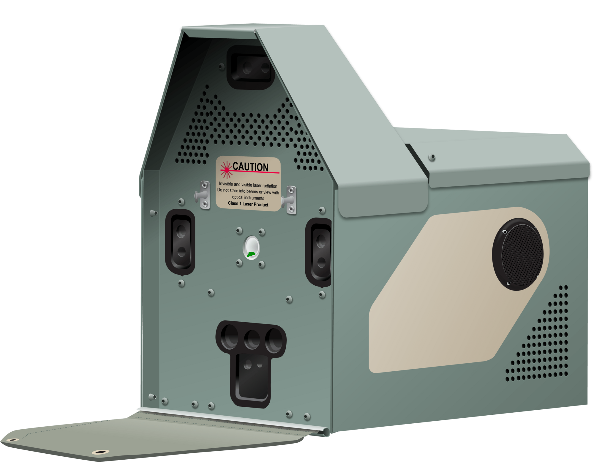
Header image: Shawn F. McCracken
Group curators
- @Nycticebus_scientia
- | he/they
MammalWeb.org
Co-founded citizen science camera-trapping project with interest in developing 100% open source wildlife tech. Advocate for open science/open research. Former Community Councilor of the Gathering for Open Science Hardware.


- 4 Resources
- 25 Discussions
- 3 Groups
trying to understand and improve the welfare of all animals that can suffer

- 4 Resources
- 6 Discussions
- 7 Groups
- @briannajohns
- | she/they
Gathering for Open Science Hardware (GOSH)
Interested in the application of open source technologies for conservation research.


- 9 Resources
- 5 Discussions
- 4 Groups
No showcases have been added to this group yet.

Aeracoop & Dronecoria
Computer engineer, Drone Pilot, Seed researcher, Wild Tech Maker


- 3 Resources
- 37 Discussions
- 11 Groups

- 0 Resources
- 0 Discussions
- 10 Groups
My name is Sean Hill and I have been using off the shelf consumer drones and open source photogrammetry and Geographic Information Systems Software (GIS) since 2019 for conservation purposes. As of 2024 I have started an online training platform called GeoWing Academy
- 1 Resources
- 23 Discussions
- 6 Groups

- @Jeorgiopierre
- | Him he his
Field researcher and systems designer operating a mobile apicultural laboratory focused on the study of terroir-specific variation in bee-derived products. Through Apis Nomadica Labs, I deliver pollination services to regional farms while simultaneously collecting ecological data
- 0 Resources
- 1 Discussions
- 10 Groups
I'm a PhD in Ecology and Evolution and co-founder of Hacking Ecology, where I coordinate projects at the intersection of open technologies and environmental data. My academic background includes investigating climate-driven shifts in microbial diversity within aquatic ecosystems.
- 0 Resources
- 0 Discussions
- 7 Groups

- @tomipiriyev
- | mr
I am maker , passionate in electronics, developer of Loko offline GPS tracker
- 0 Resources
- 6 Discussions
- 6 Groups

- @tcsmith
- | he/him
I am a conservation biologist interested in modeling social-ecological systems.
- 0 Resources
- 0 Discussions
- 11 Groups

- @LucyD
- | She/Her
Software developer and wildlife ecologist

- 0 Resources
- 2 Discussions
- 5 Groups


- 0 Resources
- 3 Discussions
- 8 Groups
- @mwanikimm
- | Mr
Ol Pejeta Conservancy
Technology and Innovations Manager
- 0 Resources
- 0 Discussions
- 7 Groups

Cellular Tracking Technologies
Biz Dev at Cellular Tracking Technologies

- 5 Resources
- 76 Discussions
- 4 Groups

- @mariaptoro
- | she/her
Colombian biologist passionate about behavioral and evolutionary ecology, specializing in amphibians. My research explores animal communication and how environmental factors shape behavior and adaptation.
- 0 Resources
- 0 Discussions
- 9 Groups
Article
September 2024 OSS paper round-up
Amanda Matthes
In this instalment: BioSense for environmental sensing, a UV data logger, KRILLSCAN for estimating krill biomass and more!
3 October 2024
Article
Project Spotlight: SnapperGPS
Brianna Johns
SnapperGPS is an open source GNSS receiver for non-real-time wildlife tracking. Learn more about the project below!
1 October 2024
Article
August 2024 OSS paper round-up
Amanda Matthes
In this instalment: HyperCoast for hyperspectral data, Fluxbot 2.0 for soil CO2 flux sensing, BirdVoxDetect for identifying bird calls, snipit for single nucleotide polymorphism visualisation and more!
15 September 2024
Article
Project Spotlight: OpenFlexure Microscope
Brianna Johns
The OpenFlexure Microscope is a low-cost, open source, and customizable microscope used worldwide. Find out more about the project and its benefits to conservation and ecology research in this post!
22 August 2024
Article

Join us in celebrating this year’s Judging Panele Award winners!
19 August 2024
Article

Join us in celebrating this year’s Community Choice Award winners!
15 August 2024
Article
Vote for your favorite submissions that best demonstrate conservation impact, novel innovation/discovery, and strong storytelling of the work and the sector.
12 August 2024
Article
July 2024 OSS paper round-up
Amanda Matthes
In this instalment: ExMove for handling animal tracking data, HawkEar for spying on animals using cameras on birds, Pytorch-wildlife for species recognition and more!
11 August 2024
Article
Open Source Solutions Announcement: Introducing New OSS Group Leaders
Brianna Johns and 2 more
We are thrilled to welcome our 3 new Group Leaders for the 2024-2025 term, Bri Johns, Amanda Matthes, and Pen-Yuan Hsing!
8 August 2024
Careers
We are recruiting an (extendable) 2-year postdoc in my group to develop new technologies (cameras, microphones, deep learning, etc) to track earthworm activity in the field.
16 July 2024
Link
Keele University - KTP position
Claire Painton
Hi everyone - I wanted to share a fantastic opportunity at Keele University for a Knowledge Transfer Partnership (KTP) position with Arribada Initiative: to be responsible for developing and writing embedded software to...
8 July 2024

August 2025

event

Louisa Richmond-Coggan
September 2025
event
Louisa Richmond-Coggan
event
Louisa Richmond-Coggan
October 2025
event

Lacey Hughey and 3 more
May 2025

event

Pen-Yuan Hsing and 5 more
December 2024
event
Pen-Yuan Hsing and 2 more

| Description | Activity | Replies | Groups | Updated |
|---|---|---|---|---|
| want to join 2025 contest for humpback whale photos in Juneo Alaska of Kelp |
|
Citizen Science, Conservation Tech Training and Education, Drones, Emerging Tech, Geospatial, Human-Wildlife Coexistence, Marine Conservation, Open Source Solutions | 2 days 9 hours ago | |
| This is awesome!! |
|
Conservation Tech Training and Education, Drones, Emerging Tech, Geospatial, Open Source Solutions | 3 days 1 hour ago | |
| Hi Elsa, We have used InVEST for a pollinator project we supported (the crop pollination model - details here), and looking to using it more for marine and coastal... |
|
Geospatial, Software Development, Climate Change, Funding and Finance, Marine Conservation, Open Source Solutions | 1 week ago | |
| Kudos for such an innovative approach—integrating additional sensors with acoustic recorders is a brilliant step forward! I'm especially interested in how you tackle energy... |
|
Acoustics, AI for Conservation, Latin America Community, Open Source Solutions | 1 week 1 day ago | |
| Hi Chris Great to meet you — and I love that you called it convergent evolution! That’s exactly how it feels when two people independently reach a similar idea because the need... |
|
Open Source Solutions | 1 week 5 days ago | |
| Amazing. Thanks for pointing them out. Didn't see it. |
|
Open Source Solutions | 1 month ago | |
| Do you know a nonprofit or organization that is looking to work with students passionate about the environment? Code the Change... |
|
AI for Conservation, Citizen Science, Conservation Tech Training and Education, Open Source Solutions, Software Development | 1 month 2 weeks ago | |
| 15 years ago I had to rebuild the dams on a game reserve I was managing due to flood damage and neglect. How I wished there was an easier,... |
|
Drones, Conservation Tech Training and Education, Data management and processing tools, Emerging Tech, Geospatial, Open Source Solutions | 4 months ago | |
| Thank you for your comment Chris! Using these tools has made a huge difference in the way we can monitor and manage Invasive Alien Vegetation. I hope you are able to integrate... |
|
AI for Conservation, Citizen Science, Conservation Tech Training and Education, Drones, Geospatial, Human-Wildlife Coexistence, Open Source Solutions | 1 month 4 weeks ago | |
| I would love to hear updates on this if you have a mailing list or list of intersted parties! |
|
AI for Conservation, Community Base, Drones, Latin America Community, Marine Conservation, Open Source Solutions, Software Development | 2 months ago | |
| Passing along a question from the Gathering for Open Science Hardware, asking about sources of funding to support in-person events... |
|
Open Source Solutions, Funding and Finance, Community Base | 2 months 1 week ago | |
| I'm excited to see this project begin; I think its focus on versatility and functionality for users in diverse environments will allow Trapper Keeper to have a broad impact,... |
|
Camera Traps, Data management and processing tools, Emerging Tech, Open Source Solutions, Software Development | 2 months 1 week ago |


Connecting the Dots: Integrating Animal Movement Data into Global Conservation Frameworks
Lacey Hughey
and 3 more
30 April 2025 1:38am
Fires in the Serengeti: Burn Severity & Remote Sensing with Earth Engine
29 April 2025 6:16pm
10 June 2025 5:39pm
No-code custom AI for camera trap images!
25 April 2025 8:33pm

28 April 2025 7:03am
When you process videos, do you not first break them down into a sequence of images and then process the images ? I'm confused as to the distinction between the processing videos versus images here.
28 April 2025 3:57pm
We do, but the way the models handle the images differs depending on whether they're coming from videos or static images. A quick example: videos provide movement information, which can a way of distinguishing between species. We use an implementation of SlowFast for one of our video models that attempts to extract temporal information at different frequencies. If the model has some concept of "these images are time sequenced" it can extract that movement information, whereas if it's a straight image model, that concept doesn't have a place to live. But a straight image model can use more of its capacity for learning e.g. fur patterns, so it can perform better on single images. We did some experimentation along these lines and did find that models trained specifically for images outperformed video models run on single images.
Hope that helps clear up the confusion. Happy to go on and on (and on)...
28 April 2025 5:58pm
Interesting. Thanks for the explanation. Nice to hear your passion showing through.
From Field to Funder: How to communicate impact?
16 April 2025 3:51pm
17 April 2025 5:04pm
Great questions @LeaOpenForests !
I don't have concrete answers since I am not a stakeholder in any project in particular. Based on experience with research on the potential for a similar one-stop-shop for science metrics, I would suggest that there is no simple solution: different actors do need and have different views on presenting and viewing impact. This means possible gaps between what one group of actors need and what the other is willing or able to produce. One can hope, search and aim for sufficient overlap, but I don't see how they would necessarily or naturally overlap.
Still, I would guess that if there are dimensions of overlap, they are time, space and actor-networks

28 April 2025 3:18pm
I have posted about this in a different group, but I love boosting the impact of my communication through use of visuals.
Free graphics relating to conservation technology and the environment are available at:
National Environmental Science Program Graphics Library
Graphics below of a feral cat with a tracking collar and a cat grooming trap are examples of symbols available courtesy of the NESP Resilient Landscapes Hub, nesplandscapes.edu.au.
UMCES Integration and Application Network Media Library
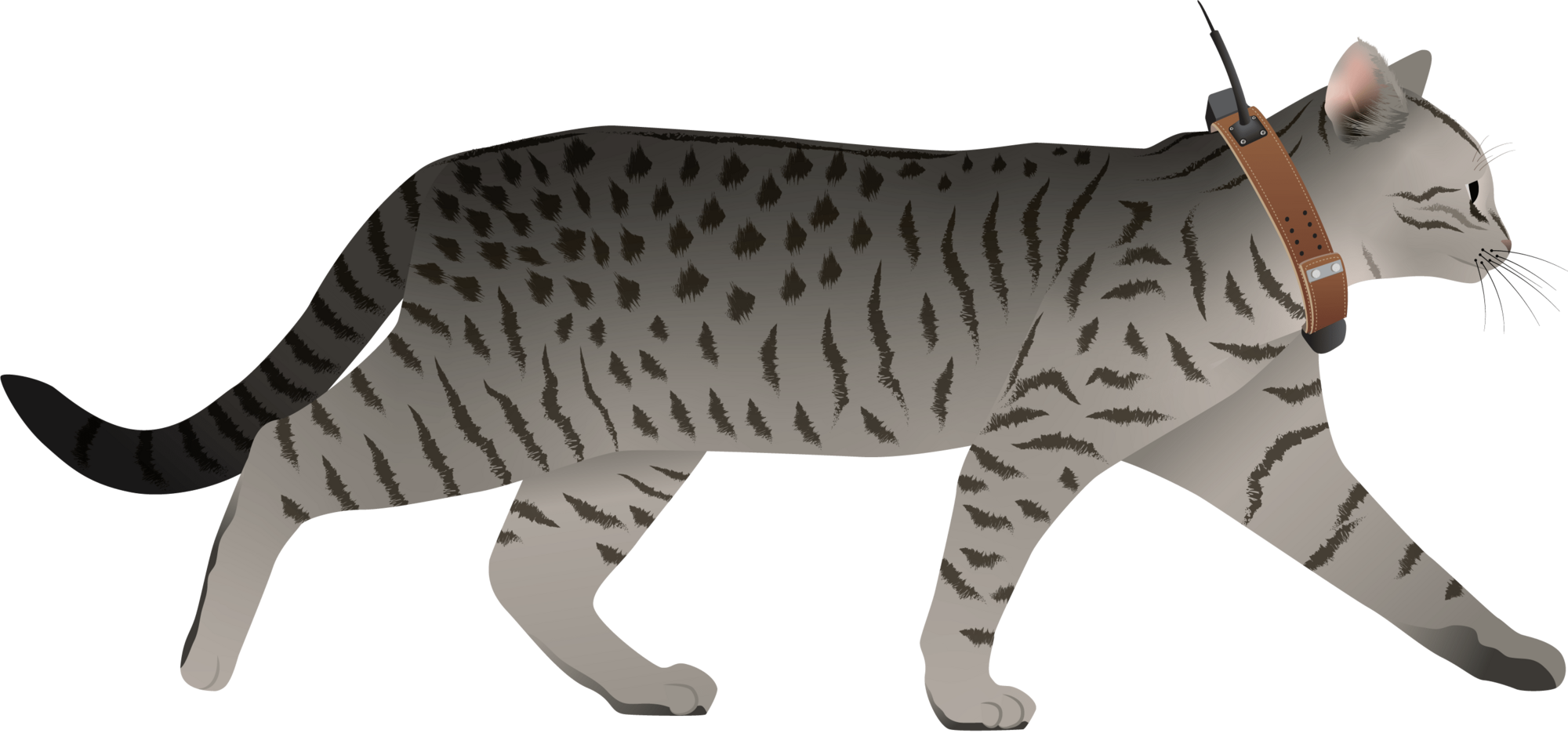
Overview of Image Analysis and Visualization from Camera traps
28 April 2025 8:09am
Ground Truth: How Are You Verifying What Maps Show?
 Léa Smadja
and 1 more
Léa Smadja
and 1 more
16 April 2025 3:35pm
DeepFaune v.1.3 is out!
14 April 2025 3:50pm
scikit-maad community

8 August 2024 10:16am

19 February 2025 10:26am
Hello!
I could be wrong, but from looking at the source code of the ACI calculation on the scikit-maad it appears that it autosets j = length of signal. If you want to break it down to e.g. 5 windows you can break the spectrogram into 5 chunks along time and then sum the ACI in each window. This gives a more similar result to the results you got using the other methods. What did you set as nbwindows for seewave?
s, fs = maad.sound.load('test_data_ACI/LINE_2003-10-30_20_00_34.wav')
Sxx, tn, fn, ext = maad.sound.spectrogram (s, fs, mode='amplitude')
full_time = Sxx.shape[1] # number of time samples in spectrogram
j_count = 5 # number of chunks we want to break it into
window_size = np.floor(full_time/j_count) # total time divided by number of chunks = number of time samples per chunk
ACI_tot = 0
for i in range(j_count):
_, _ , ACI = maad.features.acoustic_complexity_index(Sxx[:,int(i*window_size):int(i*window_size+window_size)])
ACI_tot = ACI_tot + int(ACI)
This gives ACI_tot = 1516

6 March 2025 11:07am
Hi all,
I have recently been utilising the ROI module of scikit-maad to locate non-biophonic sounds across low-sample rate Arctic hydrophone datasets and have a query about how ROI centroids are calculated...
Looking at the source code for the function "centroid_features" in .\maad\features\shape.py, I can see that the function calls "center_of_mass" from .\scipy\ndimage\_measurements.py. This to me suggests that the centroid should be placed where energy is focussed, i.e. the middle of the acoustic signature captured by the masking stage of ROI computations.
I'm a bit confused as to why the centroids I have appear to be more or less placed in the centre of the computed ROIs, regardless of the energy distribution within the ROI. The sounds I'm capturing have energy focussed towards lower frequencies of the ROI bands, so I would have expected the centroid to shift downwards as well.
Has anyone modified how ROI centroids are defined in their work? I'd be quite interested to set up centroids to signify where the peak energy level lies in the ROI, but I'm not quite sure how to do this cleanly.
Any advice would be greatly appreciated, thanks!
Kind regards,
Jonathan

11 April 2025 10:08pm
We are pleased to announce the latest release with several important enhancement, fixes and documentation improvements to ensure compatibility with the latest versions of SciPy and scikit-image as well as with Xeno-Canto.
In this new version, 2 new alpha indices are implemented, aROI and nROI, the latter being a good proxy of the average species richness per 1 min soundscape.
Releases · scikit-maad/scikit-maad · GitHub
Open-source and modular toolbox for quantitative soundscape analysis in Python - Releases · scikit-maad/scikit-maad

The boring fund: Standardizing Passive Acoustic Monitoring (PAM) data - Safe & sound

27 January 2025 3:47pm

8 February 2025 11:00pm
This is such an important project! I can't wait to hear about the results.
12 February 2025 4:15pm
Hey Sanne, awesome - we definitely need a consistent metadata standard for PAM.
If you haven't already, I would suggest sharing this on the Conservation Bioacoustics Slack channel and the AI for Conservation Slack channel. You would reach a lot of active users of PAM, including some folks who have worked on similar metadata efforts.
If you're not a member of either one of those, DM me your preferred email address and I'll send you an invite!
7 April 2025 11:07pm
Hello everyone,
Thank you all for your contribution!
You can read some updates about this project in this post.
Julia
Mothbox going to Shenzhen with Seeedstudio
6 April 2025 4:27pm
Nature Tech for Biodiversity Sector Map launched!
 Carly Batist
and 1 more
Carly Batist
and 1 more
1 April 2025 1:41pm
4 April 2025 1:57pm
Nature Tech Unconference - Anyone attending?
8 March 2025 12:11pm
15 March 2025 8:28am
Definitely!
21 March 2025 12:07pm
The Futures Wild team will be there :)

26 March 2025 7:54pm
Yep see you on friday
Generative AI for simulating landscapes before and after restoration activities

26 March 2025 1:59pm
26 March 2025 7:50pm
Yep we are working on it
🌿 Quand la Technologie Devient L'alliée du Paysagiste 🌍 | Olivier Rovellotti 🌍 | 11 comments
🌿 Quand la Technologie Devient L

1/ segment
2/remote unwanted ecosytem
3/get local potential habitat
4/generate
5/add to picture
United Nations Open Source Principles
13 March 2025 4:13pm
25 March 2025 11:54am
All sound, would be nice if there were only 5, though!
Drone Photogrammetry & GIS Introduction (Foundation) Course
 Sean Hill
and 1 more
Sean Hill
and 1 more
18 March 2025 12:47pm
Modern GIS: Moving from Desktop to Cloud
12 March 2025 7:10pm
Nature FIRST Conference: Innovation and Collaboration in Conservation
11 March 2025 9:39am
Presenters wanted: showcase your open source income streams
 Frank van der Most
and 5 more
Frank van der Most
and 5 more
17 February 2025 2:08pm
7 March 2025 12:06am
Thanks for your interest and sharing potential candidates, Vance!
7 March 2025 12:14am
Thank you for your interest @Alasdair !
7 March 2025 12:21am
It's great to see so much interest in presenting at this webinar. We have also received interest through direct messages and meetings that we've happened to have had. Thank you all for volunteering!
We will get back to you after wext week Wednesday ( 12th ) when there will be the next coordination meeting.
This date will also be the deadline for those still considering to volunteer.
Advancing Hierarchical Classification of Ocean Life

4 March 2025 10:09pm
4 March 2025 10:13pm
What are open source solutions anyway?
1 November 2024 2:21pm
11 December 2024 12:34pm
Open source technologies are a game-changer for biodiversity conservation. They give us the freedom to use, study, modify, and share vital tools and knowledge that help advance research in meaningful ways. For conservationists, this means we can adapt technologies to meet local needs, improve existing tools, and make new innovations available to everyone—creating a more collaborative and sustainable future for our planet.
It’s exciting to see the impact of open source in conservation already, with tools like Mothbox, Fieldkit, and OpenCTD helping to drive progress. I'm curious—how do the formal definitions of open source resonate with you? How do they shape the way we approach conservation?
Also, if you're interested in how open source AI can support conservation efforts, check out this article: Open Source AI Agents: How to Use Them and Best Examples.
Can’t wait to hear your thoughts! Let's keep the conversation going.

11 December 2024 9:04pm
Sorry to be a stickler on syntax when there is a richer discussion about community here - but I believe a true "open source" project is a functionally complete reference design that anyone can build upon with no strings attached. If the community isn’t provided with enough information to fully build and iterate on the design independently, then the project doesn’t truly meet the spirit of open source.
As a developer and engineer, I’ve observed that sometimes projects crowdsource free engineering work under the guise of being "open source." While this can have benefits, it can feel like asking for a free lunch from clients and customers.
Advanced features—like enterprise-level data management or tools for large-scale deployments—can reasonably remain proprietary to sustain the project financially. Transparency is critical here. If the foundational components aren’t fully open, it would be more accurate to describe the project as "community-driven" or "partially open." And as an engineer/developer I wouldn't be angry when I went to explore the project marked "open source" only to find that I have been lied to.
Just my two cents, and I really appreciate the thoughtful discussion here. The open source community has been a massive influence on me. Everything I do at work would not be possible without it. In many ways, "open source" or "public domain" projects represents the true know-how of our society.
4 March 2025 3:27pm
Thanks again for the interesting discussion everyone!
Just a note that while I touched on it in my opening post above, there were still questions in this thread about what open source tech means. I tried to address that in my new thread here:
Definitions for open source software & hardware and why they're important
27 February 2025 10:58am
28 February 2025 5:26pm
Thanks for this excellent and thought-provoking post, Pen. I agree this is a binary yes/no issue, but there is a spectrum. There could also be philosophical nuances. For example, does excluding honey from a vegan diet meet the ethical criteria of veganism? It's an animal product, so yes, but beekeeping generally doesn't have the same exploitative potential as cow, sheep, or pig husbandry, right? However, looking strictly at the definition, honey is out if you want to be vegan.
Back to software! Isn’t the main issue that companies falsely claim to offer open source hardware/software? To avoid this, do you then have to create an accreditation system? Who polices it? Is it fair? Would users care that their software has the accredited open source stamp of approval? Ultimately, we need definitions to define boundaries and speak a common language.
4 March 2025 3:21pm
Thanks @VAR1 great insights! Funny you mentioned the honey thing, @hikinghack said the same in response on the GOSH forum.
I think the point I'm trying to make with the vegan comparison is that while it might not be 100%, it is close enough for us to have productive conversations about it without running in circles because we can't even agree on what we are talking about.
As for open source tech, there actually is accreditation for open source hardware (at least of a sort). The Open Source Hardware Association has a fairly mature certificate program:
OSHWA Certification
Certification provides an easy and straightforward way for producers to indicate that their products meet a well-defined standard for open-source compliance.
I am genuinely undecided whether such a formal accreditation system is required for open source software. My undecided-ness comes back to the food/agriculture analogy, where a similar issue exists for organic certification. Being certified organic could possibly, in some cases, be beneficial. However, certification can also be very onerous for small organic farmers who can't afford to get it.
But before we even think about accreditation, I echo your last sentence that we need definitions to define boundaries. These definitions, as I argue in my original post above, is not only about principles and philosophy, they are also a practical necessity for enabling effective communication!
GPS Tracker For Wildlife
27 February 2025 12:13pm
2 March 2025 11:34am
Thank you for this valuable information!
Some of the features you mentioned can be quickly added to Loko, while others require more consideration. Loko’s communication is one-way—meaning the transmitter doesn’t know whether the receiver has received the data. This design choice is made to conserve battery life. However, all data is logged internally and can be accessed via USB.
I will add GeoTIFF loading to the Loko App. Currently, Loko is not suitable for wildlife tracking because it is not waterproof, but I am working on improving its mechanical design.
Loko already supports multiple connections, allowing many transmitters to connect to a single receiver or/and multiple receivers.
Regarding encryption: What do you mean by "Encryption should not be optional"?
Are you suggesting that communication should always be encrypted by default? on loko I made it user-configurable because encrypted data packets are 32 bytes, whereas unencrypted ones are 18 bytes. A smaller data packet improves reception sensitivity and extends the transmission range.
In your opinion, what would be a reasonable price for such a device? This is very important when adding new hardware features.
Cheers,
Akio)
2 March 2025 11:42am
Hi Herhanu , appreciate for your valuable feedbacks.
- can you explain what type of release mechanisim do you mean , picture will be much helpfull . do you mean with a remote release mechanisim activates and release the tracker from crocodile collar?
- how far data need to be sent ? with a mesh network of Loko receivers wide range of area can be covered i guess.
- long distance transmission is very challanging when transmitter is very close the ground , on crocodiles especially.
for what purpose do would you use accelerometer data? is there any specific use case?
Cheers, )

2 March 2025 11:55pm
Sure, Akio! Happy to answer!
1. Yes, something like that. The few existing i guess applied already for GPS collar (literally collar) that usually for big cats and some other big mammals. There is also GPS tag for Cetaceans that can pop up, but its only remained with the animals several days CMIIW (eg see links below)
link 1
2. I guess it depends on your research questions or project objectives. But for crocodile they can have vast home range from 100 ha to 10,000 ha (depends on species). For my species, it at least uses 500 ha of area, and the farthest between points can be 15km apart.
3. accelerometer, especially in crocodile can give insight about their movement ability. As they can random as they can be - or being a statue for hours (like when you look at crocs in the zoo). Of course this would depends on your objectives.
Hope this helps!
Cheers~
How much does it cost to incorporate Machine Learning into your drone GIS analysis process?
28 February 2025 8:44am
Mothbox Updates: Field expedition highlights - we deployed 19 Mothboxes in one go!
14 February 2025 7:48pm
Camera Trap Data Visualization Open Question

4 February 2025 3:00pm
12 February 2025 12:31pm
Hey Ed!
Great to see you here and thanks a lot for your thorough answer.
We will be checking out Trapper for sure - cc @Jeremy_ ! A standardized data exchange format like Camtrap DP makes a lot of sense and we have it in mind to build the first prototypes.
Our main requirements are the following:
- Integrate with the camtrap ecosystem (via standardized data formats)
- Make it easy to run for non technical users (most likely an Electron application that can work cross OSes).
- Make it useful to explore camtrap data and generate reports
In the first prototyping stage, it is useful for us to keep it lean while keeping in mind the interface (data exchange format) so that we can move fast.
Regards,
Arthur
12 February 2025 1:36pm
Quick question on this topic to take advantage of those that know a lot about it already. So once you have extracted all your camera data and are going through the AI object detection phase which identifies the animal types. What file formation that contains all of the time + location + labels in the photos data do the most people consider the most useful ? I'm imagining that it's some format that is used by the most expressive visualization software around I suppose. Is this correct ?
A quick look at the trapper format suggested to me that it's meta data from the camera traps and thus perform the AI matching phase. But it was a quick look, maybe it's something else ? Is the trapper format also for holding the labelled results ? (I might actually the asking the same question as the person that started this thread but in different words).
12 February 2025 2:04pm
Another question. Right now pretty much all camera traps trigger on either PIR sensors or small AI models. Small AI models would tend to have a limitation that they would only accurately detect animal types and recognise them at close distances where the animal is very large and I have question marks as to whether small models even in these circumstances are not going to make a lot of classification errors (I expect that they do and they are simply sorted out back at the office so to speak). PIR sensors would typically only see animals within say 6m - 10m distance. Maybe an elephant could be detected a bit further. Small animals only even closer.
But what about when camera traps can reliably see and recognise objects across a whole field, perhaps hundreds of meters?
Then in principle you don't have to deploy as many traps for a start. But I would expect you would need a different approach to how you want to report this and then visualize it as the co-ordinates of the trap itself is not going to give you much information. We would be in a situation to potentially have much more accurate and rich biodiversity information.
Maybe it's even possible to determine to a greater degree of accuracy where several different animals from the same camera trap image are spatially located, by knowing the 3D layout of what the camera can see and the location and size of the animal.
I expect that current camera trap data formats may fall short of being able to express that information in a sufficiently useful way, considering the in principle more information available and it could be multiple co-ordinates per species for each image that needs to be registered.
I'm likely going to be confronted with this soon as the systems I build use state of the art large number of parameter models that can see species types over much greater distances. I showed in a recent discussion here, detection of a polar bear at a distance between 130-150m.
Right now I would say it's an unknown as to how much more information about species we will be able to gather with this approach as the images were not being triggered in this manner till now. Maybe it's far greater than we would expect ? We have no idea right now.
AI for Bird and Bat Recognition
7 February 2025 11:57am
7 February 2025 5:06pm
Hi Lorenzo,
I highly recommend the OpenSoundscapes package (developed by the Kitzes Lab at U Pittsburgh) - there are workflows to build your own CNNs there, the documentation is really thorough, and the team are very responsive to inquiries. They also have a bioacoustics 'model zoo' that lists relevant models. The Perch model from Google would be good to look into as well.
Some recent papers I've seen that might also be worth checking out -
- Advanced montane bird monitoring using self-supervised learning and transformer on passive acoustic data
- A good horizon scan paper - The potential for AI to revolutionize conservation: a horizon scan
- Challenges and solutions for ecologists adopting AI
- And perhaps not directly related, but a new framework for deploying edge models onto recorders was just released - acoupi: An Open-Source Python Framework for Deploying Bioacoustic AI Models on Edge Devices
Hope that helps a bit!
acoupi: An Open-Source Python Framework for Deploying Bioacoustic AI Models on Edge Devices
7 February 2025 1:39am
[2501.17841] acoupi: An Open-Source Python Framework for Deploying Bioacoustic AI Models on Edge Devices
Abstract page for arXiv paper 2501.17841: acoupi: An Open-Source Python Framework for Deploying Bioacoustic AI Models on Edge Devices

Free/open-source app for field data collection
6 December 2024 2:04pm
4 February 2025 3:52pm
Awesome, thank you!
4 February 2025 3:57pm
Thanks! Essentially field technicians, students, researchers etc. go out into the field and find one of our study groups and from early in the morning until evening the researchers record the behaviour of individual animals at short intervals (e.g., their individual traits like age-sex class, ID, what the animal is doing, how many conspecifics it has within a certain radius, what kind of food the animal is eating if it happens to be foraging). Right now in our system things work well but we are using an app that is somewhat expensive so we want to move towards open-source
4 February 2025 4:26pm
Thanks! I am familiar with EarthRanger but wasn't aware it could be used for behavioural data collection
Can/Should UAVs Be The Answer To Urbanisation & Wildlife Conflicts
20 January 2025 11:00am
Open Hardware Summit 2025
14 January 2025 4:05pm
1 May 2025 11:44am